
5 truetrue You may select the license of your choice. English Map of Jutland Peninsula author name string: LibIchtnatz Wikimedia username: LibIchtnatz...
(5,833 × 10,536 (2.95 MB)) - 10:19, 4 June 2023

(del) (cur) 07:46, 4 May 2006 . . Astrokey44 (Talk | contribs) . .Jutland Peninsula map.PNG English...
(964 × 1,741 (118 KB)) - 04:34, 14 September 2020

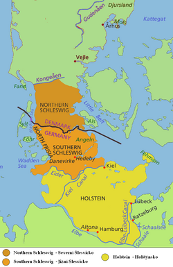
{{Information |Beschreibung = Holstein und Umgebung |Quelle = [[Datei:Jutland Peninsula map.PNG]] |Urheber = ~~~ |Datum = 13.12.2010 |Genehmigung = siehe Quelldatei...
(861 × 693 (98 KB)) - 04:27, 10 April 2023
This image is a derivative work of the following images: File:Jutland_Peninsula_map.PNG licensed with Cc-by-sa-2.5,2.0,1.0, Cc-by-sa-3.0-migrated, GFDL...
(763 × 1,176 (131 KB)) - 12:39, 8 February 2025

This image is a derivative work of the following images: File:Jutland_Peninsula_map.PNG licensed with Cc-by-sa-2.5,2.0,1.0, Cc-by-sa-3.0-migrated, GFDL...
(872 × 661 (92 KB)) - 11:14, 24 October 2020

(27485 bytes) מפה של מחוז שלזוויג ומחוז הולשטיין מפה מקורית נלקחה מ:[http://en.wikipedia.org/wiki/Image:Jutland_peninsula_2.pr], שונתה על ידי English...
(398 × 599 (175 KB)) - 02:57, 26 April 2022

This image was created using this online map creation tool archive copy at the Wayback Machine. I used 7E 69N and 13E 53.3N as the boundaries. It is a...
(514 × 774 (13 KB)) - 13:09, 12 January 2025

DescriptionJylland.PNG Map of Jutland (Danish edition of [[Image:Jutland Peninsula map.PNG]]) Date 8 June 2007 (upload date) Source Commons Author Sten...
(964 × 1,741 (178 KB)) - 09:55, 13 October 2020

jutes before their migrations to Britain Date 28 December 2007 Source Own work Author TharkunColl Other versions Based on Image:Jutland Peninsula map.PNG...
(964 × 1,741 (111 KB)) - 11:12, 24 August 2023

DescriptionPeninsulaJutlandia.PNG Español: Principales detalles de la costa de la península de Jutlandia. English: main features of Jutland peninsula. Date...
(2,359 × 3,498 (156 KB)) - 13:38, 16 October 2020

DescriptionJylland overview map.PNG Jutland and the Jutland Peninsula Red: Commonly defined as Jutland today, including the area north of the Limfjord...
(964 × 1,741 (170 KB)) - 13:08, 10 September 2020

DescriptionJylland overview map2.PNG Jutland and the Jutland Peninsula Red: Commonly defined as Jutland today, including the area north of the Limfjord...
(964 × 1,741 (171 KB)) - 05:57, 8 September 2020

DescriptionDenmark islands.PNG English: A Denmark map showing the Jutland (or Jylland) peninsula and naming notable islands. Date 25 January 2015 Source...
(804 × 625 (172 KB)) - 02:22, 25 January 2025

municipality, a municipality (Danish, kommune) in North Jutland County on the Jutland peninsula in northern Denmark until January 1, 2007. Date 28 March...
(448 × 551 (317 KB)) - 16:02, 1 December 2024