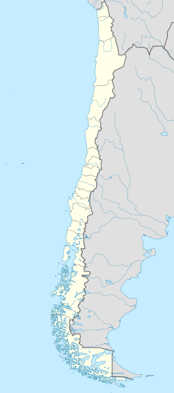
Alike 3.0 truetrue You may select the license of your choice. English Map of Chile URL: https://commons.wikimedia.org/wiki/user:NordNordWest Wikimedia username:...
(1,183 × 2,658 (925 KB)) - 07:33, 27 February 2024

4.0 Creative Commons Attribution-Share Alike 4.0 truetrue English Map of the Chilean Province of Tacna (1884-1929). Spanish Mapa de la provincia chilena...
(2,419 × 2,948 (222 KB)) - 05:12, 29 May 2025

Attribution-Share Alike 4.0 truetrue English Location map of the Captaincy General of Chile or Kingdom of Chile with the borders of 1775. Spanish Mapa de...
(1,710 × 2,679 (2.2 MB)) - 07:33, 27 February 2024

This image is a derivative work of the following images: File:Chile_location_map.svg licensed with Cc-by-sa-3.0, GFDL 2010-11-19T10:03:21Z NordNordWest...
(668 × 1,500 (496 KB)) - 00:31, 23 June 2024
|description={{en|1=Locator map of [[w:en:Chile|Chile]].}} |date=2013 |source={{en|1=[http://reliefweb.int/map/chile/chile-location-map-2013 Chile Locator Map (ReliefWeb)]}}...
(250 × 250 (101 KB)) - 15:20, 11 September 2020

This image is a derivative work of the following images: File:Chile_location_map.svg licensed with Cc-by-sa-3.0, GFDL 2009-05-20T20:05:21Z NordNordWest...
(1,262 × 2,835 (916 KB)) - 03:31, 24 November 2020

This image is a derivative work of the following images: File:Chile_location_map.svg licensed with Cc-by-sa-3.0, GFDL 2009-05-20T20:05:21Z NordNordWest...
(1,262 × 2,835 (916 KB)) - 03:31, 24 November 2020

This image is a derivative work of the following images: File:Chile_location_map.svg licensed with Cc-by-sa-3.0, GFDL 2009-05-20T20:05:21Z NordNordWest...
(1,262 × 2,835 (924 KB)) - 14:51, 7 July 2024

This image is a derivative work of the following images: File:Chile_location_map.svg licensed with Cc-by-sa-3.0, GFDL 2009-05-20T20:05:21Z NordNordWest...
(1,262 × 2,835 (915 KB)) - 21:48, 6 January 2025

Attribution-Share Alike 4.0 truetrue English Map of Continental Chile in 1899, including all disputed territories. Spanish Mapa de Chile Continental en el año 1899, incluyendo...
(1,183 × 2,679 (1.19 MB)) - 01:49, 26 June 2025

Attribution-Share Alike 4.0 truetrue English Map of Continental Chile in 1900, including all disputed territories. Spanish Mapa de Chile Continental en el año 1900, incluyendo...
(1,183 × 2,679 (1.04 MB)) - 01:49, 26 June 2025

Location map for the Chile. Originally created for English Wikipedia by Vardion. English determination method or standard: SHA-1...
(250 × 115 (9 KB)) - 09:08, 1 June 2025

der Karte:}} {{en|Location map [[w:en:Hesse|Hesse]], Germany. Geographic limits of the map:}} * N: 51 Lower Saxony location map.svg licensed with Cc-by-sa-3...
(928 × 1,116 (1.22 MB)) - 11:03, 7 March 2025

|Description=Chile location map |Source=Opera creata e caricata dall'autore (own work by uploader) based on File:Mapa de Chile.svg and File:Chile-CIA WFB Map.png...
(962 × 2,092 (820 KB)) - 08:20, 31 July 2024

file is licensed under the Creative Commons Attribution-ShareAlike 3.0 Chile license. You are free: to share – to copy, distribute and transmit the work...
(575 × 450 (974 KB)) - 22:00, 22 August 2023

This SVG map is part of a locator map series applying the widespread location map scheme. Please see root category to browse for more. FDFBEA → Marked...
(512 × 386 (1.4 MB)) - 18:30, 29 May 2025
This SVG map is part of a locator map series applying the widespread location map scheme. Please see root category to browse for more. FDFBEA → Marked...
(512 × 448 (1.8 MB)) - 18:30, 29 May 2025

This SVG map is part of a locator map series applying the widespread location map scheme. Please see root category to browse for more. FDFBEA → Marked...
(512 × 386 (556 KB)) - 18:30, 29 May 2025

file is licensed under the Creative Commons Attribution-ShareAlike 3.0 Chile license. You are free: to share – to copy, distribute and transmit the work...
(1,183 × 2,658 (919 KB)) - 07:33, 27 February 2024

under the following license: English This is a world map showing the location and shape of Chile. author name string: Sanjay Rao Wikimedia username: Onemilenorth...
(1,000 × 1,000 (182 KB)) - 07:40, 27 February 2024
This SVG map is part of a locator map series applying the widespread location map scheme. Please see root category to browse for more. FDFBEA → Marked...
(512 × 684 (2.88 MB)) - 18:30, 29 May 2025

This SVG map is part of a locator map series applying the widespread location map scheme. Please see root category to browse for more. FDFBEA → Marked...
(512 × 209 (1.77 MB)) - 18:30, 29 May 2025
This SVG map is part of a locator map series applying the widespread location map scheme. Please see root category to browse for more. FDFBEA → Marked...
(512 × 448 (1.8 MB)) - 18:30, 29 May 2025

This SVG map is part of a locator map series applying the widespread location map scheme. Please see root category to browse for more. FDFBEA → Marked...
(512 × 386 (1.4 MB)) - 18:30, 29 May 2025

File:Tacna province (1884-1929) Chile location map.svg...
(2,419 × 2,948 (134 KB)) - 19:35, 2 August 2025

truetrue English Spanish La gobernación de Chile en 1605 con "el morro Moreno, en 23°31', como lindero entre Chile y el Perú" y los efectos de la cédula de...
(1,710 × 2,679 (4.33 MB)) - 11:56, 25 February 2025
This SVG map is part of a locator map series applying the widespread location map scheme. Please see root category to browse for more. FDFBEA → Marked...
(512 × 386 (556 KB)) - 18:30, 29 May 2025

This SVG map is part of a locator map series applying the widespread location map scheme. Please see root category to browse for more. FDFBEA → Marked...
(512 × 209 (1.77 MB)) - 18:30, 29 May 2025

|Description=Chile location map |Source=Opera creata e caricata dall'autore (own work by uploader) based on File:Mapa de Chile.svg and File:Chile-CIA WFB Map.png...
(962 × 2,092 (1.05 MB)) - 13:42, 14 October 2020

under the following license: English This is a world map showing the location and shape of Chile. URL: https://commons.wikimedia.org/wiki/User:Onemilenorth...
(1,000 × 1,000 (76 KB)) - 07:40, 27 February 2024