
The A26 is a 357.6 km (222.2 mi) long French motorway connecting Calais and Troyes. It is also known as the Autoroute des Anglais (Motorway of the English)...
15 KB (1,355 words) - 14:05, 8 April 2024

Nord-Pas de Calais Mining Basin, the largest mining stub in France. A26 is named the autoroute des Anglais (motorway of the English) as it connects Calais...
49 KB (2,632 words) - 22:37, 15 April 2024

The A1 Autoroute, also known as l'autoroute du Nord (the Northern Motorway), is the busiest of France's autoroutes. With a length of 211 km (131 mi),...
9 KB (255 words) - 13:19, 31 December 2023

northern France. The road is also part of European route E44. From its western interchange with the A28 autoroute until its junction with the A26 autoroute, part...
5 KB (92 words) - 19:34, 11 January 2024
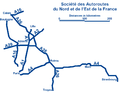
Société des Autoroutes du Nord et de l'Est de la France (Northern and Eastern French Highways Corporation) is a motorway operator company in France. It operates...
2 KB (158 words) - 08:03, 4 June 2024

The A16 autoroute – also known as L'Européenne and forming between Abbeville and Dunkirk a part of the larger Autoroute des estuaires – is a motorway...
12 KB (400 words) - 14:05, 5 May 2024
road connecting Capel and Bognor Regis A29 autoroute, a road in France connecting Le Havre with the A26 autoroute at Saint-Quentin A 29 motorway (Germany)...
957 bytes (176 words) - 12:44, 5 September 2021

List of motorways in Belgium (redirect from Autoroute (Belgium))
In Belgium, the motorways (Dutch: autosnelwegen; French: autoroutes; German: Autobahnen) are indicated by an A and an E (for European) number. The E numbers...
9 KB (770 words) - 20:02, 21 January 2024

Grand contournement de Paris (category Autoroutes in France)
A26 autoroute between Reims and Troyes. A section of A26 between Troyes and Auxerre which would partially complete the Second Solution to Autoroute standard...
4 KB (419 words) - 22:25, 15 April 2024

Troyes with Langres was known as the A26. This route crosses the departments of Seine-et-Marne (in the Ile-de-France region), Yonne (in the Burgundy region)...
9 KB (323 words) - 00:23, 13 February 2023
Route nationale 3 (redirect from Route nationale 3 (France))
(nationale) in France connecting Paris to the frontier of Germany. For the majority of its route, the RN 3 runs parallel to the A4 autoroute. As a result...
3 KB (422 words) - 21:09, 5 February 2024
Route nationale 29 (redirect from N29 road (France))
more war cemeteries before entering the town of Saint-Quentin over the A26 autoroute. Between Amiens and Longueau, it was the former N 35 and between Longueau...
3 KB (452 words) - 22:36, 13 August 2023

Angres (category CS1 French-language sources (fr))
southwest of Lens centre, at the junction of the D51 and D58e roads. The A26 autoroute passes by, just within the borders of the commune. The church of St...
3 KB (160 words) - 13:09, 30 October 2023

Biache-Saint-Vaast (category CS1 French-language sources (fr))
the Scarpe river, at the junction of the D42, D43 and D46 roads. The A26 autoroute passes by just yards from the commune. Biache-Saint-Vaast station has...
3 KB (198 words) - 07:53, 3 May 2024
Route nationale 1 (redirect from Route nationale 1 (France))
France between Paris and Calais. It is approximately 339 km (211 mi) long. The majority of the original road has been superseded by the A16 autoroute...
5 KB (675 words) - 20:20, 13 August 2023

Graincourt-lès-Havrincourt (category CS1 French-language sources (fr))
Hauts-de-France region of France. A farming village situated 22 miles (35 km) southeast of Arras, at the junction of the D15 and C5 roads. The A26 autoroute junction...
3 KB (148 words) - 06:38, 4 August 2023

Lillers (redirect from Lillers, France)
the D69 roads. The town is bypassed by the N43 to the north and the A26 autoroute to the south. The river Clarence flows through the town. After being...
5 KB (480 words) - 06:43, 4 August 2023
Inghem (category Articles with French-language sources (fr))
of Saint-Omer, at the D198 and D201 crossroads. A junction with the A26 autoroute is less than a mile away. The church of Notre-Dame, dating from the...
2 KB (136 words) - 13:05, 25 August 2023

Arras (redirect from Arras, France)
parts of France. Autoroute A26 (A26 highway) connects Arras with Calais and Reims. Autoroute A1 connecting Arras with Paris and Lille Autoroute A26 connecting...
46 KB (5,192 words) - 12:53, 25 May 2024

Gavrelle (category CS1 French-language sources (fr))
of the N50 and the D33 roads. The motorway junction of the A26 autoroute and the A1 autoroute is less than a mile away. The church of St. Vaast, dating...
3 KB (151 words) - 06:38, 4 August 2023

Marquion (category CS1 French-language sources (fr))
Arras, at the junction of the D939 and the D15 roads. Junction 8 of the A26 autoroute is just a mile away. The church of St. Aignan dating from the sixteenth...
3 KB (145 words) - 06:45, 4 August 2023

Les Attaques (category CS1 French-language sources (fr))
southeast of Calais, at the junction of the N43 and D248 roads. Both the A26 "autoroute des Anglais" and the Calais-St. Omer canal pass through the commune...
3 KB (154 words) - 06:26, 4 August 2023

Quartier Mangin (category World War II airfields in France)
of the Autoroute des Anglais (A26 autoroute) 1 Mile (1.6 km) east of the village of Couvron-et-Aumencourt. After 1967, the facility was a French Army Armée...
23 KB (3,109 words) - 16:59, 29 October 2023
Linghem (category CS1 French-language sources (fr))
Hauts-de-France region of France. Linghem is situated about 12 miles (19 km) northwest of Béthune and 34 miles (55 km) west of Lille, on the D90 road. The A26...
2 KB (124 words) - 06:43, 4 August 2023

Allouagne (category CS1 French-language sources (fr))
junction of the D188 and the D183 roads. The town is bypassed by the A26 autoroute to the north. Two manorhouses, dating from the 16th and 17th century...
3 KB (153 words) - 06:26, 4 August 2023

Labeuvrière (category CS1 French-language sources (fr))
20 miles (32 km) southwest of Lille on the D181e5, traversed by the A26 autoroute. The church of St. Christine, rebuilt, along with the rest of the village...
3 KB (150 words) - 06:42, 4 August 2023

Leulinghem (category CS1 French-language sources (fr))
(8 km) southwest of Saint-Omer, on the D212 road, half a mile from the A26 autoroute. The church of St. Maurice, dating from the twelfth century. Communes...
2 KB (131 words) - 06:43, 4 August 2023
Route nationale 16 (redirect from N16 road (France))
road continues north to the town of Lillers and a junction with the A26 autoroute (Junction 5). The town had a junction with the N43 (now RD 943) from...
3 KB (447 words) - 21:35, 13 August 2023

countryside and forest. The Baraque de Fraiture may be reached via the autoroute du Soleil (A26 / E25), exiting at junction 50 and turning onto the N30 (Liège–Bastogne)...
3 KB (293 words) - 21:07, 1 June 2024

Verquin (category CS1 French-language sources (fr))
southwest of Lille, at the junction of the D941, D937 and D72 roads. The A26 autoroute passes through the middle of the commune. The church of St. Amé, dating...
3 KB (159 words) - 06:56, 4 August 2023