
Corozal (Spanish pronunciation: [koɾoˈsal] ) is a town and municipality of Puerto Rico located in the central-eastern region, north of Orocovis and Barranquitas;...
38 KB (2,766 words) - 10:08, 30 May 2024

mountains at Adjuntas, Aibonito, and Corozal. The average yearly precipitation is 66 in (1,676 mm). Puerto Rico experiences the Atlantic hurricane season...
321 KB (32,691 words) - 11:56, 14 June 2024
in the municipality of Corozal, Puerto Rico. Its population in 2010 was 2,093. Maná was in Spain's gazetteers until Puerto Rico was ceded by Spain in the...
10 KB (749 words) - 19:45, 31 December 2023

in the municipality of Corozal, Puerto Rico. Its population in 2010 was 1,398. Negros was in Spain's gazetteers until Puerto Rico was ceded by Spain in...
10 KB (747 words) - 05:28, 1 January 2024

in the municipality of Corozal, Puerto Rico. Its population in 2010 was 363. Magueyes was in Spain's gazetteers until Puerto Rico was ceded by Spain in...
10 KB (702 words) - 19:40, 31 December 2023

the municipality of Corozal, Puerto Rico. Its population in 2010 was 1,551. Cuchillas was in Spain's gazetteers until Puerto Rico was ceded by Spain in...
11 KB (839 words) - 01:38, 6 February 2024

the municipality of Corozal, Puerto Rico. Its population in 2010 was 3,060. Dos Bocas was in Spain's gazetteers until Puerto Rico was ceded by Spain in...
10 KB (804 words) - 20:25, 10 February 2024

in the municipality of Corozal, Puerto Rico. Its population in 2010 was 2,262. Abras was in Spain's gazetteers until Puerto Rico was ceded by Spain in...
12 KB (924 words) - 18:59, 18 January 2024

the municipality of Corozal, Puerto Rico. Its population in 2010 was 3,653. Padilla was in Spain's gazetteers until Puerto Rico was ceded by Spain in...
9 KB (729 words) - 05:31, 1 January 2024

the municipality of Corozal, Puerto Rico. Its population in 2010 was 3,458. Palos Blancos was in Spain's gazetteers until Puerto Rico was ceded by Spain...
12 KB (1,007 words) - 16:28, 3 February 2024

in the municipality of Corozal, Puerto Rico. Its population in 2010 was 5,387. Cibuco was in Spain's gazetteers until Puerto Rico was ceded by Spain in...
10 KB (781 words) - 03:49, 28 December 2023

the municipality of Corozal, Puerto Rico. Its population in 2010 was 6,068. Palmarejo was in Spain's gazetteers until Puerto Rico was ceded by Spain in...
11 KB (868 words) - 05:32, 1 January 2024

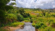
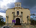
Corozal barrio-pueblo is an urban barrio and the administrative center (seat) of Corozal, a municipality of Puerto Rico. Its population in 2010 was 2...
13 KB (1,073 words) - 15:19, 30 May 2024

in the municipality of Corozal, Puerto Rico. Its population in 2010 was 2,991. Pueblo was in Spain's gazetteers until Puerto Rico was ceded by Spain in...
10 KB (714 words) - 06:22, 1 January 2024

Statistical Area. It's located north of Villalba and Coamo; south of Morovis and Corozal; southeast of Ciales; east of Jayuya; and west of Barranquitas Since before...
32 KB (2,526 words) - 15:11, 17 February 2024
Civic Architecture in Porto Rico, 1920 Having been a Spanish possession until 1898, the system of local government in Puerto Rico bears more resemblance...
122 KB (1,766 words) - 11:49, 7 June 2024

ISBN 9781461520696. Reid, Harry Fielding; Taber, Stephen (1919). The Porto Rico earthquake of 1918 with descriptions of earlier earthquakes: Report of...
30 KB (2,980 words) - 20:25, 12 June 2024

municipality of Puerto Rico located in the central region of the island, south of Toa Alta; north of Barranquitas and Comerío; east of Corozal; and west of Bayamón...
28 KB (2,154 words) - 00:44, 5 April 2024
Palmarito (redirect from Palmarito, Corozal, Puerto Rico)
the municipality of Corozal, Puerto Rico. Its population in 2010 was 2,227. Palmarito was in Spain's gazetteers until Puerto Rico was ceded by Spain in...
10 KB (721 words) - 05:32, 1 January 2024

municipality located in the Cordillera Central region of Puerto Rico, south of Corozal and Naranjito; north of Coamo and Aibonito; west of Comerío and...
37 KB (2,469 words) - 05:33, 23 April 2024

Barceloneta, and Corozal. For its high levels of erosion, Rincón is vulnerable in the case of a major hurricane. Like all municipalities of Puerto Rico, Rincón...
31 KB (2,414 words) - 01:15, 6 February 2024

Puerto Rico, 1899, United States. War Dept. Porto Rico Census Office (in Spanish). Imprenta del gobierno. p. 161. "Report of the Census of Porto Rico 1899"...
9 KB (677 words) - 05:18, 4 June 2024
present day municipalities of Aibonito, Orocovis, Barranquitas, Morovis and Corozal. The Taíno language name Orocobix or O-roco-bis literally means: 'Remembrance...
3 KB (271 words) - 12:21, 2 April 2024
of Puerto Rico located in the northern coast of the island, north of Naranjito; south of Dorado and Toa Baja; east of Vega Alta and Corozal; and west...
27 KB (1,910 words) - 01:43, 6 February 2024

Puerto Rico Highway 159 in Quebrada Arenas Puerto Rico Highway 806 between Toa Alta and Corozal Puerto Rico portal List of communities in Puerto Rico List...
9 KB (685 words) - 06:28, 1 January 2024
The flag of Puerto Rico (Spanish: Bandera de Puerto Rico), officially known as the flag of the Commonwealth of Puerto Rico (Spanish: Bandera del Estado...
137 KB (13,405 words) - 02:38, 14 June 2024

Puerto Rico located in the central region of the island, north of Orocovis, south of Manatí, Vega Baja and Vega Alta; east of Ciales, and west of Corozal. Morovis...
39 KB (2,993 words) - 02:23, 28 February 2024

Sector Olmo Rodríguez, Sector Ricos Place, Sector Salida a Barranquitas, Sector Salida a Coamo, Sector Salida a Corozal, Sector Salida a Morovis, Sector...
10 KB (761 words) - 07:23, 1 January 2024

September 21, 2017. "Report of the Census of Porto Rico 1899". War Department Office Director Census of Porto Rico. Archived from the original on July 16,...
29 KB (2,232 words) - 13:29, 27 April 2024

Morovis barrio-pueblo (redirect from Morovis, Morovis, Puerto Rico)
Puerto Rico, 1899, United States. War Dept. Porto Rico Census Office (in Spanish). Imprenta del gobierno. p. 161. "Report of the Census of Porto Rico 1899"...
12 KB (978 words) - 12:27, 16 January 2024