
Lyng is a civil parish in Somerset, England, comprising the villages of West Lyng and East Lyng and the hamlet of Bankland. The name derives from the...
8 KB (894 words) - 16:28, 5 May 2023

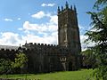
The Church of St Bartholomew at East Lyng in the parish of Lyng, Somerset, England dates from the 14th century and has been designated as a Grade I listed...
3 KB (295 words) - 17:30, 23 April 2022
Athelney (redirect from Athelney, Somerset)
located between the villages of Burrowbridge and East Lyng in the Sedgemoor district of Somerset, England. The name is believed to be derived from the...
5 KB (602 words) - 08:39, 20 May 2024
Suffolk, England in the 14th century Lyng, Norfolk, village and civil parish Lyng, Somerset, villages and civil parish Lyng, West Midlands, an area of West...
626 bytes (107 words) - 21:00, 12 August 2022
"heath", and the other as a toponymic surname referring to the parish of Lyng, Somerset. Lings is a variant of the English surname Ling, with addition of an...
10 KB (1,172 words) - 10:11, 28 January 2024
Harptree, East Horrington, East Huntspill, East Lambrook, East Lydford, East Lyng, Easton, Easton in Gordano, Eastover, East Pennard, East Quantoxhead, East...
18 KB (1,121 words) - 09:09, 21 October 2021

Institute. Marston is buried in the cemetery of St Bartholomew's at East Lyng, Somerset, England. "Search Results for England & Wales Deaths 1837-2007". "Search...
5 KB (400 words) - 23:24, 12 May 2024
Bartholomew's Church, Lower Sapey, Worcestershire St Bartholomew's Church, Lyng, Somerset Church of St Bartholomew, Notgrove, Gloucestershire St Bartholomew's...
5 KB (551 words) - 06:27, 31 May 2024
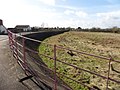
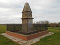
Balt Moor Wall (category Archaeological sites in Somerset)
earthwork and listed scheduled ancient monument in Lyng, Somerset, England, situated on the Somerset Levels to the northwest of the River Tone. The site...
3 KB (331 words) - 07:26, 16 February 2022

Sedgemoor (redirect from Sedgemoor, Somerset, England)
coordinates) GPX (secondary coordinates) Sedgemoor is a low-lying area of land in Somerset, England. It lies close to sea level south of the Polden Hills, historically...
31 KB (826 words) - 11:22, 27 January 2024
Yeovil–Taunton line (redirect from Lyng Halt railway station)
Railway (B&ER) to connect its main line with the market town of Yeovil in Somerset. It opened in 1853 using the broad gauge of 7 ft 1⁄4 in (2,140 mm) and...
21 KB (3,061 words) - 05:44, 1 January 2024

The Somerset Levels are a coastal plain and wetland area of Somerset, England, running south from the Mendips to the Blackdown Hills. The Somerset Levels...
118 KB (11,543 words) - 19:21, 23 April 2024

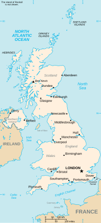
Somerset is a historic county in the south west of England. There is evidence of human occupation since prehistoric times with hand axes and flint points...
73 KB (8,205 words) - 21:02, 27 February 2024
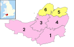
districts and two unitary authorities. The districts of Somerset are South Somerset, Somerset West and Taunton, Mendip and Sedgemoor. The two administratively...
229 KB (4,312 words) - 23:39, 30 August 2023

A361 road (category Roads in Somerset)
2014. "Floods on Somerset Moors (levels) 25 Nov 2012 near East Lyng". David Orr. Retrieved 1 February 2013. "Flood Warnings A361 East Lyng to Burrowbridge"...
11 KB (1,022 words) - 10:00, 4 June 2024
Thomas Moore (Roundhead) (category Deputy Lieutenants of Somerset)
side in the English Civil War. Moore was the son of Thomas Moore of Lyng Manor, Somerset. In April 1640, Moore was elected Member of Parliament for Heytesbury...
4 KB (284 words) - 15:28, 18 May 2024
The Somerset Victoria County History is an encyclopaedic history of the county of Somerset in England, forming part of the overall Victoria County History...
9 KB (794 words) - 02:40, 20 April 2022
1477; Norton Sub Hamdon, around 1485; and Hinton St George, around 1492) Lyng and Middlezoy (combining Langport, Cheddar and Mendip features with new features)...
80 KB (2,830 words) - 00:36, 21 November 2022
Lydford Somerset 51°04′N 2°37′W / 51.07°N 02.61°W / 51.07; -02.61 ST5731 East Lyng Somerset 51°02′N 2°57′W / 51.04°N 02.95°W / 51.04; -02.95 ST3328...
44 KB (26 words) - 22:59, 26 February 2023
48°N 00.66°E / 52.48; 00.66 TL8191 Lyng Norfolk 52°43′N 1°02′E / 52.71°N 01.04°E / 52.71; 01.04 TG0617 Lyng Somerset 51°02′N 2°58′W / 51.04°N 02.97°W...
48 KB (26 words) - 19:19, 7 May 2024
Devon 51°13′N 3°50′W / 51.21°N 03.83°W / 51.21; -03.83 SS7248 West Lyng Somerset 51°02′N 2°59′W / 51.04°N 02.98°W / 51.04; -02.98 ST3128 West Lynn...
50 KB (26 words) - 02:49, 27 February 2023

North Curry (redirect from Knapp, Somerset)
North Curry is a village and civil parish in Somerset, England, 5 miles (8.0 km) east of Taunton. The parish, which includes several hamlets, had a population...
9 KB (983 words) - 13:22, 27 September 2023
North Petherton (redirect from North Newton, Somerset)
civil parish in Somerset, England, situated on the edge of the eastern foothills of the Quantocks, and close to the edge of the Somerset Levels. The town...
27 KB (3,256 words) - 18:18, 10 November 2023
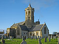
St Gregory's Church, Stoke St Gregory (category Grade I listed churches in Somerset)
church in Somerset, England. Its parish is part of the Athelney Benefice, along with the parishes of St Michael, Burrowbridge, St Bartholomew, Lyng and SS...
6 KB (405 words) - 17:39, 2 August 2023
List of scheduled monuments in Sedgemoor (category Archaeological sites in Somerset)
Retrieved 15 November 2014. "Balt Moor Wall, between East Lyng and Athelney, Lyng". Somerset Historic Environment Record. South West Heritage Trust. Retrieved...
90 KB (2,929 words) - 15:31, 28 February 2024

List of scheduled monuments in Taunton Deane (category Archaeological sites in Somerset)
August 2014. "Balt Moor Wall, between East Lyng and Athelney, Lyng". Somerset Historic Environment Record. Somerset County Council. Retrieved 20 August 2014...
43 KB (1,660 words) - 00:10, 6 June 2024

North Moor (category Sites of Special Scientific Interest in Somerset)
676.3 hectare biological Site of Special Scientific Interest near Lyng in Somerset, England. It was designated a Site of Special Scientific Interest in...
2 KB (124 words) - 01:08, 16 March 2023

Bridgwater and Taunton Canal (category Canals in Somerset)
about 12 miles (19 km) long. It included a 700-yard (640 m) embankment at Lyng, which was 40 feet (12 m) high, two short cuttings, eleven brick-built bridges...
37 KB (4,528 words) - 21:42, 16 November 2023
Hundred of Andersfield (category Hundreds of Somerset)
Broomfield, Chilton Trinity, Creech St Michael, Durleigh, Enmore, Goathurst, Lyng and, from the 1670s, the Petherton limit tithing of North Petherton. "Andersfield...
4 KB (180 words) - 01:31, 6 January 2024

South West England (section Somerset)
Cornwall (including the Isles of Scilly), Dorset, Devon, Gloucestershire, Somerset and Wiltshire. Cities and large towns in the region include Bath, Bristol...
188 KB (17,703 words) - 21:10, 8 June 2024