
Swisstopo is the official name for the Swiss Federal Office of Topography (in German: Bundesamt für Landestopografie; French: Office fédéral de topographie;...
17 KB (2,188 words) - 10:47, 17 May 2024

National Maps of Switzerland (redirect from Swisstopo maps)
Switzerland, also referred to as the Swisstopo maps, are a set of official map series designed, edited and distributed by Swisstopo, the Swiss Federal Office of...
4 KB (426 words) - 07:44, 5 September 2023

mountains of Switzerland accessible by public transport Retrieved from the Swisstopo topographic maps. The key col is the Furggeli (1,732 m). Media related...
2 KB (81 words) - 13:54, 7 July 2023
background Retrieved from the IGN topographic maps [1] Retrieved from the Swisstopo topographic maps [2]. The lowest col between the Jura and the Alps is...
2 KB (127 words) - 22:16, 8 October 2023

Map 1:25 000. Berne, Switzerland: Swiss Federal Office of Topography – swisstopo. 2012. ISBN 978-3-302-01208-7. Retrieved 2016-08-21. "Harder Kulm". Jungfrau...
3 KB (236 words) - 14:47, 4 May 2024
Liechtenstein for maps and surveying by the Swiss Federal Office of Topography (Swisstopo). A first coordinate system was introduced in 1903 under the name LV03...
7 KB (968 words) - 17:51, 30 December 2023

Titlis from Pilatus List of mountains of Switzerland Retrieved from the Swisstopo topographic maps [1] and Google Earth. The key col is the Susten Pass...
8 KB (810 words) - 21:15, 28 May 2023

side. It has an elevation of 1,699 metres (5,574 ft) above sea level and is located in the canton of Schwyz. Swisstopo maps Rigi Hochflue on Hikr v t e...
1 KB (71 words) - 11:59, 29 April 2024
destination of the classic hike: Schynige Platte-Faulhorn-First. Retrieved from the Swisstopo topographic maps Cable car website First on Hikr v t e...
2 KB (69 words) - 16:20, 23 June 2022

List of highest road passes in Switzerland Albula Pass, Swisstopo topographic maps Swisstopo maps, official maps of Switzerland by the Swiss government...
4 KB (340 words) - 16:06, 2 July 2023

mountains of Switzerland accessible by public transport Retrieved from the Swisstopo topographic maps and Google Earth. The key col is located east of the...
4 KB (377 words) - 18:43, 7 April 2024

1:200 000 (in German). Cartography by Swiss Federal Office of Topography swisstopo. Berne, Switzerland: Federal Office for the Environment FOEN. 2014. Retrieved...
92 KB (10,623 words) - 22:15, 16 May 2024
swisstopo). Berne, Switzerland: Swiss Federal Office of Topography – swisstopo. 28 February 2016. Retrieved 2016-10-04. Retrieved from the Swisstopo topographic...
4 KB (384 words) - 12:01, 29 April 2024

named Sätteli (975 m) is located north of the summit. Retrieved from the Swisstopo topographic maps. The key col is located near Ewegstafel at 960 metres...
2 KB (113 words) - 20:13, 15 May 2022

although dialectically the feminine remains current. Retrieved from the Swisstopo topographic maps. The key col is the Holzegg (1,405 m). "33 Toggenburg"...
3 KB (266 words) - 15:50, 24 July 2022
1:25,000 swisstopo topographic maps: "National Map 1:25,000" (official site). Wabern, Switzerland: Federal Office of Topography - swisstopo. 12 March...
50 KB (464 words) - 09:57, 30 May 2024
Colligatarch, the de facto ruler of the world, is located inside Uri Rotstock. Swisstopo maps Google Earth Wikimedia Commons has media related to Uri Rotstock...
1 KB (72 words) - 23:58, 6 May 2022

the exit in Geneva According to the Swiss Federal Office of Topography, Swisstopo, Lac de Genève designates that part of the Petit Lac which lies within...
39 KB (2,823 words) - 17:58, 23 May 2024
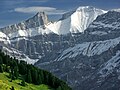
is Lake Oeschinen. List of mountains of Switzerland Retrieved from the Swisstopo topographic maps. The key col is the Fründenjoch (2,983 m) Retrieved from...
2 KB (69 words) - 14:54, 23 April 2024
Bern northeast of the main summit of the Diablerets. Retrieved from the Swisstopo topographic maps. The key col is the Oldensattel (2,737 m). Sanetschhorn...
2 KB (69 words) - 09:04, 25 April 2024

Explorer Map Symbols Archived 1 November 2012 at the Wayback Machine; Swisstopo, Conventional Signs Archived 26 July 2011 at the Wayback Machine; United...
20 KB (2,043 words) - 19:20, 2 May 2024

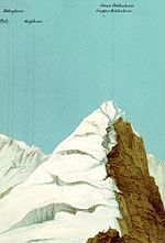
The Western Lyskamm (German: Liskamm Westgipfel) is a subsidiary peak of the Lyskamm. Swisstopo map v t e v t e...
1 KB (21 words) - 21:50, 11 May 2022

"Search.ch" (Map). Schulhaus Hofern. Cartography by search.ch, TomTom, swisstopo, osm. Zurich, Switzerland: Tamedia AG. Retrieved 2015-04-23. "Zentrum...
17 KB (1,518 words) - 03:30, 22 May 2024

lowest border crossing between the Pas de Morgins and the Dents du Midi. Retrieved from the Swisstopo topographic maps. Col de Cou on Hikr v t e v t e...
1 KB (78 words) - 18:16, 1 January 2024

Bern Parent range Bernese Alps Topo map Swiss Federal Office of Topography swisstopo Geology Mountain type mountain ridge Climbing Easiest route Railway...
6 KB (539 words) - 05:09, 28 September 2021

Alps. Because of its prominence it was included in the enlarged list of alpine four-thousanders. Swisstopo maps List of Alpine four-thousanders v t e...
1 KB (41 words) - 11:31, 30 April 2024

documentation for details. https://shop.swisstopo.admin.ch/en/products/maps/national/lk100?layer=ch.swisstopo.landeskarte100_papier...
154 KB (15,010 words) - 16:21, 16 May 2024
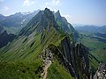
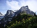
ridge between Ebenalp and the Säntis. It is the northernmost peak rising above 2,000 metres in Switzerland. Swisstopo maps Altenalp Türm on Hikr.org...
1 KB (45 words) - 07:52, 12 May 2023

Edizioni, 2012, p. 140-145. ISBN 978-88-8191-281-0 Retrieved from the Swisstopo topographic maps "50 Via Spluga". Chur, Switzerland: Graubünden Tourism...
7 KB (823 words) - 11:58, 17 April 2023
https://web.archive.org/web/20120607113752/http://www.swisstopo.admin.ch/internet/swisstopo/en/home/topics/knowledge/center_ch.html https://web.archive...
2 KB (203 words) - 07:31, 13 May 2024