
The Vtáčnik Mountains (Slovak: Pohorie Vtáčnik) are a mountain range in central Slovakia, which forms part of the Slovak Central Mountains (Slovenské stredohorie)...
3 KB (170 words) - 09:34, 26 April 2024
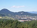
located in the Handlovka brook valley, surrounded by the mountain ranges of Vtáčnik in the west and Žiar in the south, east and north, in the historical region...
8 KB (587 words) - 22:00, 16 May 2024


SK: Slovenské stredohorie, EN: Slovakian mid-mountainous region Vtacnik Mountains (Vtáčnik) Pohronský Inovec Štiavnica Mountains (Štiavnické vrchy) Kremnica...
32 KB (2,938 words) - 19:22, 18 February 2024

Nitra Region. It is surrounded by the Danubian Lowland, Pohronský Inovec, Vtáčnik Mountains and the Upper Nitra Basin. Beech trees are predominate in the...
3 KB (226 words) - 17:46, 15 March 2023
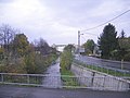
language translates to meanders. Zákruty are sourced in the Vtáčnik Mountains, in Lower Vtáčnik sub-range, on the northern slopes of Ivanišov Vrch at an...
5 KB (307 words) - 18:26, 26 December 2023

north, Strážov Mountains in the centre, Považský Inovec in the south, Vtáčnik in the south-east and Žiar in the east. Small parts of Lesser Fatra and...
13 KB (720 words) - 20:12, 15 February 2024
0 mi) long and its basin size is 176 km2 (68 sq mi). Its source is in the Vtacnik Mountains, near the Biely kameň. It is located at an elevation of 244 meters...
2 KB (154 words) - 14:11, 13 January 2020

located. Some of the mountain ranges in the west include Kremnica Mountains, Vtáčnik and Štiavnica Mountains. The Javorie and Krupina Plain ranges are located...
13 KB (776 words) - 04:30, 23 May 2024
Ružinov Vrútky 821 04 Bratislava 2 Vtáčikova cesta Rača 831 06 Bratislava 35 Vtáčnik Nové Mesto 831 01 Bratislava 37 Vyhliadka Karlova Ves vyhliadka 841 05...
170 KB (66 words) - 05:26, 20 September 2023

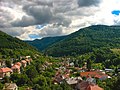
located in the Žiar Basin in central Slovakia, on the Hron River, between Vtáčnik and Štiavnické vrchy mountain ranges. According to the 2001 census, the...
5 KB (256 words) - 08:51, 11 March 2024

Mountains, in the north Malá Fatra, in the east Žiar and in the south Vtáčnik. Prievidza is the eleventh largest city in Slovakia. It is located around...
24 KB (1,772 words) - 08:08, 11 March 2024
potok is sourced on lower eastern slopes of Sulina of the Vtáčnik Mountains, in the Lower Vtáčnik sub-range, at an altitude of just under 520 meters, over...
4 KB (296 words) - 07:51, 2 April 2024

the northwest and west, Javorníky in the north, Malá Fatra in the east, Vtáčnik and Nitra river in the south and Považský Inovec in the southwest. The...
4 KB (459 words) - 05:55, 29 January 2023
Basin in the east, Žiar Basin and Štiavnica Mountains in the south, and Vtáčnik in the west. The highest mountain is Flochová at 1,317 m. The Kremnica...
1 KB (139 words) - 22:53, 29 January 2022

Slovakia. The town is located in the upper Nitra River valley, between the Vtáčnik and Strážovské vrchy ranges, about 10 km (6.21 mi) from Prievidza. The...
6 KB (319 words) - 08:04, 11 March 2024
landscape areas in Slovakia. The Landscape Area is situated in the Tribeč and Vtáčnik mountains, in western Slovakia. It is situated in the Nitra, Zlaté Moravce...
3 KB (186 words) - 20:17, 15 May 2020

IUCN category V (protected landscape/seascape) Strážov Mountains from Vtáčnik Mts. Location West Slovakia: Strážov Mountains and Súľov Mountains Coordinates...
3 KB (205 words) - 15:12, 30 November 2021

Podtatranská kotlina Hornádska kotlina (Hornád Basin) Horehronské podolie Vtáčnik Pohronský Inovec Štiavnické vrchy (Štiavnica Mountains) Kremnické vrchy...
7 KB (339 words) - 18:40, 5 January 2024

Slovak Central Mountains are divided into the following subdivisions: Vtacnik Mountains Pohronský Inovec Štiavnica Mountains Kremnica Mountains Poľana...
2 KB (182 words) - 15:57, 2 April 2023

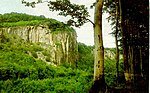
m) - the best view of the southern mountains - Kremnické vrchy, Poľana, Vtáčnik Tlstá (1,208 m) - view of Turiec basin Ploská Typical rocks of the Bralná...
8 KB (784 words) - 14:47, 1 July 2021

Danubian Hills (Podunajská pahorkatina) in the south and Pohronský Inovec, Vtáčnik and Žiar Basin (Žiarska kotlina) in the west. The highest point is Sitno...
2 KB (214 words) - 13:22, 5 July 2022

altitude of 450 metres, covering an area of 16.71 km². It is part of the Vtáčnik mountain range, within the Slovak Central Mountains. The municipality has...
5 KB (181 words) - 10:21, 29 September 2022

(Štiavnica Mountains on the east, Pohronský Inovec on the south-west and Vtáčnik on the north-west). Seven kilometers from Nová Baňa, close by the village...
8 KB (503 words) - 19:30, 10 March 2024

extent. In central Slovakia, volcanic rock formed the Poľana, Kremnica, and Vtáčnik Mts. Rhyodacite tuffs in sediments of Lower Badenian are known in the Zemplín...
38 KB (4,618 words) - 13:31, 28 May 2024