
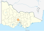
The Shire of Yarriambiack is a local government area of Victoria, Australia, located in the north-western part of the state. It covers an area of 7,326...
9 KB (439 words) - 09:10, 7 September 2023

southern Mallee region of Victoria, Australia. The town is in the Shire of Yarriambiack local government area, 395 kilometres north-west of the state capital...
3 KB (222 words) - 23:30, 1 June 2024
region of western Victoria, Australia. The town is located in the Shire of Yarriambiack local government area, 417 kilometres (259 mi) north west of the...
3 KB (105 words) - 10:20, 7 May 2023
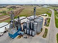
legal battle over the use of the term "silo art trail", with the Yarriambiack Shire Council in Victoria attempting to trademark it in 2017, with GrainCorp...
38 KB (5,065 words) - 10:50, 6 June 2024

This is a list of places on the Victorian Heritage Register in the Shire of Yarriambiack in Victoria, Australia. The Victorian Heritage Register is maintained...
4 KB (63 words) - 17:34, 9 February 2024

Mulwaree Shire (abolished) Murrumbidgee Murrundindi Shire Ngaanyatjarraku Nillumbik Shire Orana Region Pilbara Warringah Shire Yarriambiack Shire Kooragang...
56 KB (1,989 words) - 06:17, 5 June 2024

Rupanyup in 1876. The town used to be in the Shire of Dunmunkle but was allocated to the Shire of Yarriambiack when Victoria's municipalities were re-organized...
3 KB (193 words) - 05:25, 8 August 2023

area in the north part of the Shire of Yarriambiack (around Hopetoun). It does include the southern part of the Shire of Buloke, which is not part of...
13 KB (1,327 words) - 10:32, 12 November 2023

The Shire of Mornington Peninsula is a local government area in southeastern Metropolitan Melbourne, Victoria, Australia. It is located to the south of...
8 KB (365 words) - 06:02, 15 February 2024
The Shire of Cardinia is a local government area in Victoria, Australia, in the south-east of Melbourne between Western Port and the Yarra Ranges on the...
11 KB (690 words) - 17:45, 10 February 2024

The Surf Coast Shire is a local government area in the Barwon South West region of Victoria, Australia, located in the south-western part of the state...
16 KB (694 words) - 16:22, 3 March 2024

Australia. The shire was bounded by the Yarriambiack Creek on the western boundary and the Richardson River on the east. The shire covered an area of...
4 KB (310 words) - 11:33, 12 May 2023

320 kilometres (199 mi) north west of Melbourne. It is in the Shire of Yarriambiack local government area. At the 2016 census, Minyip had a population...
9 KB (1,041 words) - 22:48, 21 March 2024

southern Mallee districts, and hosts local government offices of the Shire of Yarriambiack. At the 2011 census, Warracknabeal district had a population of...
14 KB (1,530 words) - 01:51, 1 May 2024

north-west of the state capital, Melbourne. The town is in the Shire of Yarriambiack local government area. At the 2016 census, Murtoa had a population...
10 KB (1,182 words) - 21:46, 28 December 2023

amalgamation of the Shire of Cobram, Shire of Nathalia, Shire of Numurkah, and parts of the Shire of Tungamah and Shire of Yarrawonga. The Shire is governed and...
9 KB (453 words) - 18:52, 10 February 2024

created Shire of Northern Grampians, whilst the Kewell West and Wallup districts were transferred to the newly created Shire of Yarriambiack. Wimmera...
5 KB (353 words) - 11:38, 12 May 2023
Australia, 144 kilometres (89 mi) south of the urban centre of Mildura in Yarriambiack Shire. Turriff borders the Wathe Flora and Fauna Reserve, a breeding ground...
4 KB (335 words) - 10:45, 8 August 2023
The Shire of Macedon Ranges is a region in Central Victoria, Australia, best known for its native forests, geographical attraction Hanging Rock, and artisan...
12 KB (651 words) - 08:30, 12 May 2024

the Shire of Pyalong, the Shire of Kilmore, most of the Shire of Broadford, and parts of the Shire of McIvor and Rural City of Seymour. The Shire is governed...
8 KB (493 words) - 11:54, 16 June 2024

amalgamation of the Shire of Creswick, Shire of Daylesford and Glenlyon and parts of the Shire of Kyneton and Shire of Talbot and Clunes. The shire is governed...
11 KB (462 words) - 15:17, 9 May 2024

Colac, Shire of Colac, part of the Shire of Otway and part of the Shire of Heytesbury. The Shire is governed and administered by the Colac Otway Shire Council;...
13 KB (690 words) - 20:41, 24 March 2024

The Shire of Glenelg is a local government area in the Barwon South West region of Victoria, Australia, located in the south-western part of the state...
11 KB (540 words) - 10:48, 30 November 2023

400 km (249 mi) north-west of Melbourne on the Henty Highway in the Shire of Yarriambiack. In the 2016 census, Hopetoun had a population of 739. The town...
6 KB (370 words) - 09:55, 7 May 2023

The Shire of Nillumbik (/ˈnɪləmbɪk/ NILL-əm-bik) is a local government area in Victoria, Australia. It contains outer northern suburbs of Melbourne and...
10 KB (556 words) - 19:49, 10 February 2024

City of Melton (redirect from Melton Shire)
district on 16 September 1862, and became a shire on 24 May 1871. Parts of the north and south ridings of the Shire of Braybrook (later City of Sunshine) were...
13 KB (897 words) - 21:03, 20 May 2024

of the former Shire of South Gippsland with the Shire of Mirboo, and parts of the Shire of Korumburra and Shire of Woorayl. The Shire is governed and...
11 KB (460 words) - 17:49, 10 February 2024

the amalgamation of the Shire of Kaniva and parts of the Shire of Kowree, Shire of Arapiles and Shire of Glenelg. The Shire is governed and administered...
9 KB (487 words) - 19:53, 10 February 2024
Airport IATA: HTU ICAO: YHPN Summary Airport type Public Operator Yarriambiack Shire Council Location Hopetoun, Victoria Elevation AMSL 256 ft / 78 m Coordinates...
1 KB (51 words) - 22:20, 6 May 2023

in the Mallee region of Victoria, Australia. The town is in the Shire of Yarriambiack local government area and on the Sunraysia Highway, 359 kilometres...
7 KB (628 words) - 00:22, 3 October 2023