
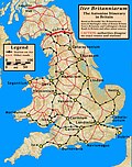
Dere Street or Deere Street is a modern designation of a Roman road which ran north from Eboracum (York), crossing the Stanegate at Corbridge (Hadrian's...
25 KB (2,027 words) - 10:41, 29 January 2024

the same map misattributing Dere Street as "Watling Street" Roman Britain Roman roads in Britain The Widow of Watling Street, an apocryphal Shakespearean...
40 KB (2,652 words) - 08:13, 23 May 2024
Iraqi Kurdistan Dere, Karaman, a village in Karaman Province, Turkey Dere, Kozluk, a village in Batman Province, Turkey Dere Street, a Roman road from...
892 bytes (143 words) - 00:08, 22 March 2024

Roman road in Northumberland, in North East England. It branches off Dere Street north of Corbridge and can be traced through Northumberland for about...
7 KB (750 words) - 17:52, 19 December 2023

bypass, Roman burials, glass and coins were found, and some traces of Dere Street. To return to the previous route of the A68 it is concurrent with the...
10 KB (924 words) - 00:46, 9 June 2024
Batham Gate, Roman road Dere Street, Roman road Ermine Street, Roman road Fosse Way, Roman road Icknield Street, Roman Road Stane Street (Chichester), Roman...
12 KB (1,175 words) - 10:23, 11 November 2023

armies had crossed into England, they had used the Stainmore Pass or Dere Street and were engaged in battle to the east of the Pennines. Livingston speculates...
51 KB (6,283 words) - 19:47, 16 April 2024

Watling Street was 10.1 m (33 ft) wide while the Fosse Way was little more than half that. Several unnamed roads were wider than Watling Street, such as...
39 KB (3,425 words) - 21:01, 15 February 2024
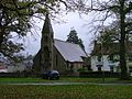
site of a Roman fort of AD 260–270, which was built at the point where Dere Street crossed the River Tees. Part of the fort is under the village green....
17 KB (1,540 words) - 21:09, 29 January 2024
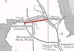
crossings: Corstopitum (Corbridge) on the River Tyne in the east (situated on Dere Street) and Luguvalium (Carlisle) (on the River Eden) in the west. The Stanegate...
11 KB (1,386 words) - 16:38, 26 February 2024

short section of Ermine Street, the Roman Rigg or Roman Ridge. Further north the Great North Road crossed the Roman Dere Street near Boroughbridge from...
13 KB (1,703 words) - 04:51, 21 February 2024
originated from being the junction where the north–south Roman road known as "Dere Street", which crossed the River Tees at Piercebridge, met the Roman road which...
12 KB (1,125 words) - 12:28, 15 February 2024

Sunday market is held. It lies on the route of the old Roman road of Dere Street and is the site of the Roman fortification of Cataractonium. The etymology...
23 KB (2,690 words) - 15:26, 28 May 2024

The fort is part of the defensive system built along the extension of Dere Street, a Roman road running from York to Corbridge and onwards to Melrose....
7 KB (893 words) - 11:05, 28 May 2024

town formed a leg of both Dere Street—connecting Eboracum (York) to the Antonine Wall—and the Roman equivalent of Watling Street, which here connected Eboracum...
9 KB (1,091 words) - 14:09, 17 November 2023
a major Roman town, Isurium Brigantum, which marked the crossing of Dere Street, the Roman Road from York north to the Antonine Wall via Corbridge and...
6 KB (660 words) - 11:18, 18 May 2024

Brusselton Wood. Hagg's Lane formed part of the Roman road known as Dere Street. The first recorded reference to Shildon came during the Anglo-Saxon...
36 KB (4,229 words) - 06:48, 22 April 2024

town in the Roman Empire, lying at the junction of the Stanegate and Dere Street, the two most important local Roman roads. The first fort was established...
13 KB (1,366 words) - 20:10, 13 June 2024

120s AD. It was located 60 miles north of the wall on the extension of Dere Street the main Roman route to the north, initially in seemingly "hostile" territory...
20 KB (2,453 words) - 20:18, 4 May 2024
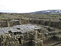
strategically located on the junction of a major Roman north–south road (Dere Street) with the River Tyne and the Roman Stanegate road, which was also the...
15 KB (1,327 words) - 11:06, 31 March 2024

somewhere on the banks of the River Tyne, probably at Corbridge where Dere Street crosses the river. The Battle of Corbridge appears to have been indecisive;...
53 KB (7,212 words) - 05:35, 13 June 2024
of the River Wear by Dere Street, the main Roman road between York, Hadrian's Wall and Scotland, and also the fort's main street (via principalis). Sitting...
21 KB (2,011 words) - 18:19, 13 November 2023
(5 km) downstream past St Boswells to Maxton. Near Maxton the trail joins Dere Street, which it follows south east past the site of the Battle of Ancrum Moor...
8 KB (809 words) - 16:32, 26 February 2024

Longovicium (or Lanchester Roman Fort) was an auxiliary fort located on Roman Dere Street, in the Roman province of Britannia Inferior. It is located just southwest...
16 KB (1,369 words) - 07:43, 17 July 2022

Road of Ankara United Kingdom Akeman Street Camlet Way Dere Street Ermine Street Fen Causeway Fosse Way King Street London-West of England Roman Roads Peddars...
61 KB (7,734 words) - 19:36, 9 May 2024
camps, near Dere Street, are scheduled monuments. The two camps, about 500 metres (1,600 ft) apart, are situated on either side of Dere Street, a Roman road...
4 KB (393 words) - 06:02, 4 April 2024

Roxburghshire. The site, alongside the course of the Roman road known as Dere Street, consists of the remains of four Roman temporary camps, a linear earthwork...
7 KB (771 words) - 14:54, 8 April 2022

the Roman fort at Chew Green, and briefly follows the Roman road of Dere Street. The path then follows the border ridge, passing the high point of Windy...
30 KB (3,097 words) - 19:49, 9 March 2024

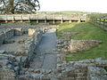
the site is under Piercebridge village green. The fort was situated on Dere Street, the major Roman road linking York to the north. The fort was strategically...
24 KB (2,009 words) - 19:53, 21 May 2024

connecting them with a network of roads. It is thought that the course of Dere Street ran through this area connecting the forts such as Binchester with Hadrian's...
6 KB (770 words) - 11:49, 6 October 2023