
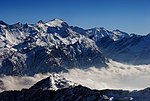
of the Güferhorn and separating the valleys of Länta and Canaltal, both converging at the Zervreilasee, south of Vals. Swisstopo maps Güferhorn on Hikr...
2 KB (99 words) - 01:12, 2 May 2022

sources are located in the Adula Alps (Rheinwaldhorn, Rheinquellhorn, and Güferhorn). The Avers Rhine joins from the south. One of its headwaters, the Reno...
94 KB (10,713 words) - 21:16, 15 June 2024

called Meter über Meer (m ü. M.) in Switzerland: Rheinwaldhorn (3,402 m) Güferhorn (3,379 m) Pizzo Tambò (3,279 m) Grauhorn (3,260 m) Läntahorn (3,237 m)...
9 KB (805 words) - 02:37, 18 May 2024

Aosta Valley IT 1863 207 Güferhorn 3379 400 46°30′45″N 09°03′47″E / 46.51250°N 9.06306°E / 46.51250; 9.06306 (207. Güferhorn (3379 m)) Adula Alps I/B-10...
109 KB (1,721 words) - 11:57, 30 May 2024
gained the col (Lenta Pass) in the ridge between the Rheinwaldhorn and Güferhorn. From thence the way lay along the arête. This was very narrow, and in...
7 KB (839 words) - 09:58, 5 October 2023

49111°N 9.75972°E / 46.49111; 9.75972 Albula Alps Graubünden 1859 82 271 Güferhorn 3379 400 46°30′45″N 09°03′47″E / 46.51250°N 9.06306°E / 46.51250; 9...
76 KB (1,275 words) - 09:36, 22 May 2024

highest summit around the sources of the Hinter Rhine, and, in 1806, the Güferhorn (11,132 ft.), the second summit of that region; in 1792, the Oberalpstock...
4 KB (454 words) - 13:38, 16 March 2023

Name Elevation m ft Monte Leone 3,553 11,684 Rheinwaldhorn 3,402 11,149 Güferhorn 3,393 11,132 Blinnenhorn 3,384 11,103 Basodino 3,276 10,749 Pizzo Tambò...
13 KB (438 words) - 14:10, 27 May 2024

Google Earth. The nearest point of higher elevation is southeast of the Güferhorn. Paul Caminada, Pioniere der Alpentopographie: die Geschichte der Schweizer...
3 KB (276 words) - 21:47, 4 May 2022
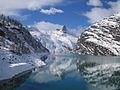
rising to over 3,000 metres. The highest visible from the lake is the Güferhorn (3,379 m), located on the south side. Other peaks are the Fanellhorn (3...
3 KB (183 words) - 23:54, 3 October 2023

49111°N 9.75972°E / 46.49111; 9.75972 Albula Alps Graubünden 1859 144 Güferhorn 3379 400 46°30′45″N 09°03′47″E / 46.51250°N 9.06306°E / 46.51250; 9...
55 KB (359 words) - 09:40, 22 May 2024

/ 46.49111°N 9.75972°E / 46.49111; 9.75972 Albula Alps Maloja 1859 Güferhorn 3379 400 46°30′45″N 09°03′47″E / 46.51250°N 9.06306°E / 46.51250; 9...
27 KB (336 words) - 16:08, 5 May 2024