Highway 67, commonly referred to as Highway 67, is a provincially maintained highway in the northern portion of the Canadian province of Ontario that connects...
9 KB (813 words) - 18:34, 25 April 2024

Ontario (/ɒnˈtɛərioʊ/ on-TAIR-ee-oh; French: [ɔ̃taʁjo]) is the southernmost province of Canada. Located in Central Canada, Ontario is the country's most...
162 KB (13,398 words) - 20:00, 15 June 2024

runs from its western terminus in Astoria to the Idaho border east of Ontario. West of Portland, US 30 generally follows the southern shore of the Columbia...
36 KB (2,200 words) - 22:34, 25 May 2024
List of secondary highways in Algoma District (redirect from Ontario Route 546)
populated areas in the Algoma District of northeastern Ontario. Some of the shorter ones are also access routes for communities with moderate amounts of tourism...
32 KB (2,521 words) - 21:20, 16 January 2024
in the Canadian province of Ontario. Comprising a privately leased segment as well as a publicly owned segment, the route spans the entire Greater Toronto...
107 KB (8,333 words) - 22:59, 19 May 2024
List of secondary highways in Cochrane District (redirect from Ontario Route 572)
connecting Iroquois Falls, Ontario to Highway 11/Trans Canada Highway, and to Highway 101. This provides a very direct route for Timmins-Iroquois Falls...
18 KB (1,354 words) - 10:20, 11 August 2022
are numbered 67: Fitzroy Developmental Road – Queensland State Route 67 Alberta Highway 67 (former) Manitoba Highway 67 Highway 67 (Ontario) Finnish national...
6 KB (476 words) - 23:07, 4 April 2024
List of secondary highways in Thunder Bay District (redirect from Ontario Route 527)
in the Canadian province of Ontario, which serves to connect the small community of Hurkett to Highway 17, the main route of the Trans-Canada Highway...
30 KB (1,905 words) - 15:53, 3 September 2023

Ontario. U.S. Route 53 also ends here. On the other side of the bridge, Trans-Canada Highway (Ontario Highway 11) is an east–west route while Ontario...
33 KB (3,488 words) - 09:36, 16 January 2024
as "Main Street Ontario" and was one of the first roads in what would later become Ontario. It was devised as an overland military route between York (Toronto)...
131 KB (9,529 words) - 22:24, 9 June 2024
Black River before curving east. Returning to wilderness, the route zig-zags towards the Ontario–Quebec border near Rouyn-Noranda, travelling several kilometres...
20 KB (1,726 words) - 16:34, 15 May 2024
List of secondary highways in Kenora District (redirect from Ontario Route 116)
maintained secondary highway in the Canadian province of Ontario. Located in Kenora District, the route branches off Highway 17, the Trans-Canada Highway, between...
30 KB (2,153 words) - 02:37, 7 July 2023
It is also a Core Route in the National Highway System of Canada. The route is maintained by the Ministry of Transportation of Ontario (MTO) and patrolled...
228 KB (16,186 words) - 11:38, 17 June 2024
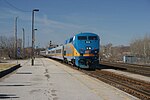
Quebec City–Windsor Corridor (Via Rail) (category Via Rail routes)
provinces of Quebec and Ontario. The Corridor service area has the heaviest passenger train frequency in Canada and contributes 67% of Via's revenue. Prior...
13 KB (1,286 words) - 11:39, 19 March 2024

separating Michigan in the United States from Ontario, Canada. The twin cities of Sault Ste. Marie, Ontario, and Sault Ste. Marie, Michigan are connected...
17 KB (1,677 words) - 07:52, 27 May 2024

Temiskaming Shores (redirect from Haileybury, Ontario)
Temiskaming Shores is a city in the Timiskaming District in Northeastern Ontario, Canada. It was created by the amalgamation of the town of New Liskeard...
23 KB (2,082 words) - 12:17, 8 March 2024
provincially maintained highway and the primary route of the Trans-Canada Highway through the Canadian province of Ontario. It begins at the Manitoba boundary, 50 km...
89 KB (6,792 words) - 21:13, 16 January 2024
Highway Network consists of all the roads in Ontario maintained by the Ministry of Transportation of Ontario (MTO), including those designated as part of...
119 KB (11,363 words) - 08:06, 29 May 2024
smaller towns and communities. Once the primary east–west route across the southern portion of Ontario, most of Highway 2 was bypassed by Highway 401, which...
85 KB (5,555 words) - 07:21, 20 April 2024
Canadian province of Ontario that connects Highways 401 and 403 to Brampton. North of Brampton, the commuter freeway ends and the route becomes Highway 10...
34 KB (3,191 words) - 01:16, 19 April 2024
border between the provinces of Ontario and Quebec, east of which the four lane freeway continues as Autoroute 40. The route proceeds west, south of the former...
62 KB (5,032 words) - 06:30, 17 April 2024
List of secondary highways in Timiskaming District (redirect from Ontario Route 558)
province of Ontario. The highway is 7.6 kilometres (4.7 mi) in length, connecting Highway 112 in Dane with the now abandoned Adams Mine site. The route was designated...
17 KB (982 words) - 16:49, 10 April 2023

Boise metropolitan area (redirect from Boise City-Mountain Home-Ontario, ID-OR CSA)
Highway 67 State Highway 69 State Highway 72 State Highway 78 State Highway 167 Oregon Route 52 Oregon Route 78 Oregon Route 201 Oregon Route 451 Oregon...
17 KB (874 words) - 04:15, 7 May 2024
route is signed at 80 km/h (50 mph). Like other provincial routes in Ontario, Highway 48 is maintained by the Ministry of Transportation of Ontario....
23 KB (1,938 words) - 22:31, 9 June 2024
List of secondary highways in Rainy River District (redirect from Ontario Route 600)
a secondary highway in the Canadian province of Ontario, located in Rainy River District. The route connects Highway 71 (the Trans-Canada Highway) with...
8 KB (525 words) - 15:52, 3 September 2023
Queen Elizabeth Way (redirect from Ontario Route QEW)
in Ontario, the QEW is directionally signed using locations along the route as opposed to cardinal directions. Driving towards Toronto, the route is signed...
95 KB (9,203 words) - 01:31, 15 June 2024
Trans-Canada Highway (TCH), the Georgian Bay Route, and is part of the highest-capacity route from southern Ontario to the Canadian West, via a connection with...
81 KB (6,022 words) - 19:06, 16 June 2024

Selwyn is a township in central-eastern Ontario, Canada, located in Peterborough County. The township comprises a mix of rural areas and built up urban...
16 KB (1,218 words) - 15:38, 3 May 2024
406, is a 400-series highway in the Canadian province of Ontario. The primary north–south route through the central portion of the Niagara Peninsula, Highway 406...
24 KB (1,949 words) - 06:24, 17 April 2024
the former route of Highway 83. From there, it continues north, passing through the communities of Hensall, Ontario and Vanastra, Ontario before terminating...
24 KB (1,308 words) - 22:07, 30 January 2024