
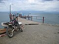
Golfito is a district and port town of the Golfito canton, in the Puntarenas province of Costa Rica, located on the southern Pacific Coast, near the border...
9 KB (872 words) - 07:04, 13 April 2024
Puerto Jiménez (redirect from Puerto Jiménez de Golfito)
one of the original two districts of Golfito canton on 10 June 1949 through decree 552, the other one being Golfito. Due to the distance from the local...
9 KB (744 words) - 12:43, 2 January 2024
Golfito is a canton in the Puntarenas province of Costa Rica. The head city is in Golfito district. Golfito was created on 10 June 1949 by decree 532...
6 KB (324 words) - 12:55, 2 January 2024

Rail transport in Costa Rica (section Golfito Railroad)
47, Laurel and Golfito. Right-of-way is now owned by Incofer. Several locomotives were cosmetically restored and can be seen in Golfito. There was a railway...
22 KB (2,283 words) - 08:59, 22 May 2024
La Gamba (section Region (Golfito et Rio Claro))
La Gamba is a village in the Guaycará District of Golfito canton, which is part of Puntarenas Province of Costa Rica. Village inhabitants are employed...
8 KB (1,319 words) - 21:19, 1 December 2023

Transport in Costa Rica (section Road transportation)
operated by JAPDEVA. Moín Container Terminal, operated by APM Terminals. Golfito Puerto Quepos Puntarenas (cruise ships only) Caldera Port total: 2 ships...
6 KB (651 words) - 05:48, 23 January 2024
population of approximately 450. It is located 9.5 kilometers south of Golfito. Zancudo is located on a long and narrow peninsula, sometime only 100 yards...
4 KB (278 words) - 04:38, 26 January 2024
San Vito, Costa Rica (section Road transportation)
government of Costa Rica undertook to construct a highway between San Vito and Golfito. Cattle farming was very successful. Tourism is only just beginning in...
13 KB (1,619 words) - 21:19, 1 December 2023
National Route 238 (Costa Rica) (category Infobox road maps tracking category)
a National Road Route of Costa Rica, located in the Puntarenas province. In Puntarenas province the route covers Golfito canton (Golfito district), Corredores...
3 KB (64 words) - 20:45, 25 January 2023

Limón (section Road transportation)
Juan Cayasso (b. 1961), retired striker. Henry Cooper (b. 1989), striker (Golfito). Víctor Coto (b. 1990), striker. Enrique Díaz (b. 1959), retired midfielder...
30 KB (2,559 words) - 04:54, 25 December 2023
National Route 14 (Costa Rica) (category Infobox road maps tracking category)
a National Road Route of Costa Rica, located in the Puntarenas province. In Puntarenas province the route covers Golfito canton (Golfito, Guaycará districts)...
3 KB (57 words) - 18:01, 21 March 2024
Guaycará (section Road transportation)
Guaycará is a district of the Golfito canton, in the Puntarenas province of Costa Rica. Guaycará was created on 26 November 1971 by Decreto Ejecutivo...
4 KB (220 words) - 21:19, 1 December 2023
Pavón, Costa Rica (section Road transportation)
Pavón is a district of the Golfito canton, in the Puntarenas province of Costa Rica. The town, also known as Pavones, is located near the mouth of the...
4 KB (261 words) - 07:26, 16 April 2024
La Cuesta (section Road transportation)
La Cuesta was created on 19 October 1973 by Ley 5373. Segregated from Golfito canton. La Cuesta has an area of 37.06 km² and an elevation of 38 metres...
4 KB (216 words) - 21:19, 1 December 2023
Cureña (section Road transportation)
population of 951 inhabitants. The 12 population centers of the district are: Golfito (head of the district) Caño Tambor Copalchí Cureñita Paloseco Remolinito...
5 KB (320 words) - 18:30, 31 December 2023
destinations: Costa Rica domestic routes Arenal, Costa Rica Drake Bay, Costa Rica Golfito, Costa Rica Liberia, Costa Rica Limon, Costa Rica Nosara, Costa Rica Puerto...
15 KB (1,369 words) - 11:11, 25 May 2024
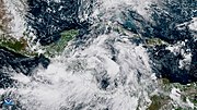
Martha led to street flooding and inundated areas in Costa Rica, namely in Golfito. The effects of Martha resulted in five deaths in the country. The nation...
42 KB (3,861 words) - 00:20, 13 February 2024

secured to build the highway connecting the airport to downtown San José. The road access to the airport is on an exit at Route 1, and near the exit to Alajuela...
39 KB (1,998 words) - 17:44, 26 May 2024

Rica, Bethune was bitten by a deadly Fer-de-lance snake. He was taken to Golfito Hospital and admitted to the Intensive Care Unit. He was released from...
63 KB (6,794 words) - 16:01, 22 May 2024
Corredor District (section Road transportation)
Corredor was created on 19 October 1973 by Ley 5373. Segregated from Golfito canton. Corredor has an area of 276.37 km² and an elevation of 46 metres...
4 KB (221 words) - 10:26, 24 December 2023
Pital, San Carlos (section Road transportation)
district) Piedra Alegre El Encanto Los Ángeles Veracruz Chaparrón El Palmar Golfito Cuatro Esquinas La Josefina Puerto Escondido Yucatán Tierras Buenas Coopeisabel...
6 KB (492 words) - 21:45, 5 December 2023
Canoas District (section Road transportation)
Rica. Canoas was created on 19 October 1973 by Ley 5373. Segregated from Golfito canton. Canoas has an area of 122.54 km2 and an elevation of 128 metres...
4 KB (215 words) - 08:18, 14 April 2024
Andres Bello Av, El Golfito sector, it has a monument to Saint Benedict of Palermo. Miraflores square. Carabobo square, between H road and Cumana Av. Note:...
25 KB (3,312 words) - 19:10, 6 April 2024

bringing torrential rainfall. Flooding was reported in Corredores, Coto Brus, Golfito, and Osa. Streets and residences were damaged by the floods. At least 7...
24 KB (2,491 words) - 20:47, 12 April 2024
Pan-American Highway. The runway lies alongside an unpaved field access road. There are distant hills north of Dieciocho Airport. The David VOR-DME (Ident:...
2 KB (141 words) - 09:08, 8 March 2020
and snorkeling. As there are no roads to Playa Cativo, a 30 minutes scenic boat ride will take residents to Golfito or Puerto Jiménez, and often are...
3 KB (410 words) - 00:44, 7 February 2023

National Route 2 (Costa Rica) (category Infobox road instances in Costa Rica)
Boruca, Brunka districts), Osa canton (Palmar, Piedras Blancas districts), Golfito canton (Guaycará district), Corredores canton (Corredor, Canoas districts)...
12 KB (981 words) - 20:37, 25 January 2023
development on the SW margin of the Caribbean Plate: Insights from the Golfito, Costa Rica, and Azuero, Panama, complexes" (PDF). Geochemistry, Geophysics...
153 KB (17,307 words) - 10:49, 7 May 2024

most of the capital city of San José. Numerous streets were inundated in Golfito. Damage in Costa Rica reached $30 million and 5 deaths were reported. The...
81 KB (7,631 words) - 02:33, 21 May 2024
Indonesia". earthquake.usgs.gov. Retrieved 2018-08-17. "M 6.1 - 19km NNW of Golfito, Costa Rica". earthquake.usgs.gov. Retrieved 2018-08-17. "Damage and power...
158 KB (6,387 words) - 01:51, 28 May 2024