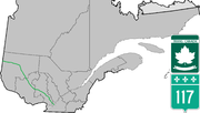
King's Highway 66, commonly referred to as Highway 66, is a provincially-maintained highway in the Canadian province of Ontario. Located in the Timiskaming...
11 KB (780 words) - 17:23, 17 May 2024
television series Route 66. Originally scheduled for November 22, 1963, but delayed due to the assassination of John F. Kennedy "Route 66 (TV series) – Black...
44 KB (79 words) - 00:54, 25 May 2024
highways are numbered 66: Barkly Highway (Northern Territory) Riddoch Highway Alberta Highway 66 Highway 66 (Ontario) Kantatie 66 (Orivesi — Lapua) A66...
7 KB (534 words) - 23:07, 4 April 2024

Route 66 is an American adventure crime drama television series that premiered on CBS on October 7, 1960, and ran until March 20, 1964, for a total of...
35 KB (3,903 words) - 08:47, 28 April 2024
This is a List of Ontario Tourist Routes throughout the province, which are designated to highlight places of cultural, environmental, or social importance...
27 KB (2,929 words) - 14:58, 29 April 2023
List of secondary highways in Algoma District (redirect from Ontario Route 546)
populated areas in the Algoma District of northeastern Ontario. Some of the shorter ones are also access routes for communities with moderate amounts of tourism...
32 KB (2,521 words) - 21:20, 16 January 2024
List of secondary highways in Thunder Bay District (redirect from Ontario Route 527)
in the Canadian province of Ontario, which serves to connect the small community of Hurkett to Highway 17, the main route of the Trans-Canada Highway...
30 KB (1,905 words) - 15:53, 3 September 2023

State Route 66 (SR 66) is a state highway in the U.S. state of California that runs along a section of old U.S. Route 66 in Los Angeles and San Bernardino...
9 KB (798 words) - 06:09, 7 February 2024
List of secondary highways in Cochrane District (redirect from Ontario Route 572)
connecting Iroquois Falls, Ontario to Highway 11/Trans Canada Highway, and to Highway 101. This provides a very direct route for Timmins-Iroquois Falls...
18 KB (1,354 words) - 10:20, 11 August 2022
the Quebec/Ontario border where it continues as Highway 66 east of McGarry, Ontario. It is an important road since it is the only direct route between southern...
18 KB (747 words) - 22:51, 13 May 2024
County routes in Ontario County, New York, provide main arterial connections that are not otherwise provided by state highways. County routes never enter...
15 KB (190 words) - 16:54, 11 March 2022
in the Canadian province of Ontario. Comprising a privately leased segment as well as a publicly owned segment, the route spans the entire Greater Toronto...
107 KB (8,333 words) - 22:59, 19 May 2024
Albert Okura (section Route 66 restoration)
revitalization of Historic Route 66. In 2005, Okura purchased the town of Amboy, California, which is located along Route 66. The corporate headquarters...
9 KB (920 words) - 22:55, 16 April 2024
as "Main Street Ontario" and was one of the first roads in what would later become Ontario. It was devised as an overland military route between York (Toronto)...
131 KB (9,529 words) - 20:33, 15 May 2024
List of secondary highways in Timiskaming District (redirect from Ontario Route 558)
province of Ontario. The highway is 7.6 kilometres (4.7 mi) in length, connecting Highway 112 in Dane with the now abandoned Adams Mine site. The route was designated...
17 KB (982 words) - 16:49, 10 April 2023

Trans-Canada Highway (redirect from Route Transcanadienne)
continue as non-TCH routes outside the designated sections) en route. In addition, Ontario and Quebec use standard provincial highway shields to number...
63 KB (7,875 words) - 02:31, 25 May 2024
List of secondary highways in Kenora District (redirect from Ontario Route 116)
maintained secondary highway in the Canadian province of Ontario. Located in Kenora District, the route branches off Highway 17, the Trans-Canada Highway, between...
30 KB (2,153 words) - 02:37, 7 July 2023
northern portion of the Canadian province of Ontario. Formerly part of the Ferguson Highway, the route was designated with its own number in 1953, prior...
6 KB (490 words) - 15:45, 22 May 2024

runs from its western terminus in Astoria to the Idaho border east of Ontario. West of Portland, US 30 generally follows the southern shore of the Columbia...
36 KB (2,200 words) - 22:34, 25 May 2024

province of Ontario. The route begins at Highway 66 and travels 123.3 kilometres (76.6 mi) southeast to the Quebec border. At its midpoint, the route is concurrent...
8 KB (553 words) - 16:29, 16 November 2023

Orange Freeway) situated to the west and I-15 (the Ontario Freeway) located to the east. When the route runs through Chino Hills and Chino, there is a high-occupancy...
15 KB (1,340 words) - 10:40, 5 March 2024

smaller towns and communities. Once the primary east–west route across the southern portion of Ontario, most of Highway 2 was bypassed by Highway 401, which...
85 KB (5,555 words) - 07:21, 20 April 2024
It is also a Core Route in the National Highway System of Canada. The route is maintained by the Ministry of Transportation of Ontario (MTO) and patrolled...
227 KB (16,107 words) - 23:30, 1 May 2024
border between the provinces of Ontario and Quebec, east of which the four lane freeway continues as Autoroute 40. The route proceeds west, south of the former...
62 KB (5,032 words) - 06:30, 17 April 2024

town in the Regional Municipality of Peel in the Greater Toronto Area of Ontario, Canada. The name comes from a shortened form of Caledonia, the Roman name...
37 KB (2,881 words) - 00:08, 14 May 2024
Highway Network consists of all the roads in Ontario maintained by the Ministry of Transportation of Ontario (MTO), including those designated as part of...
119 KB (11,363 words) - 00:38, 30 March 2024

Temiskaming Shores (redirect from Haileybury, Ontario)
Temiskaming Shores is a city in the Timiskaming District in Northeastern Ontario, Canada. It was created by the amalgamation of the town of New Liskeard...
23 KB (2,082 words) - 12:17, 8 March 2024
provincially maintained highway and the primary route of the Trans-Canada Highway through the Canadian province of Ontario. It begins at the Manitoba boundary, 50 km...
89 KB (6,792 words) - 21:13, 16 January 2024
route is signed at 80 km/h (50 mph). Like other provincial routes in Ontario, Highway 48 is maintained by the Ministry of Transportation of Ontario....
23 KB (1,938 words) - 14:43, 28 March 2024

42°51′N 77°17′W / 42.85°N 77.29°W / 42.85; -77.29 Ontario County is a county in the U.S. State of New York. As of the 2020 census, the population was...
26 KB (2,184 words) - 18:02, 26 April 2024