
example, colors can be used to indicate a classification of roads. These signs are usually explained in the margin of the map, or on a separately published...
20 KB (2,055 words) - 15:28, 25 May 2025
crowdsourced contributions to Google Maps were not discontinued as the company announced those features would be transferred to the Google Local Guides program...
164 KB (14,286 words) - 00:43, 17 July 2025

Nautical map Physical map Political map Relief map Resource map Road map Star map Street map Thematic map Topographic map Train track map Transit map Weather...
36 KB (4,352 words) - 10:27, 31 July 2025
allowed cartographers to estimate the extent of their geographical knowledge, and to indicate parts of the planet known to exist but not yet explored as terra...
74 KB (8,610 words) - 04:58, 21 July 2025

References today to the Fuller projection or Dymaxion usually indicate this version. Unlike other polyhedral map projections, the Dymaxion map does not use a gnomonic...
13 KB (1,367 words) - 00:51, 12 July 2025
HTTP 404 (redirect from 404 File Not Found)
standard response code, to indicate that the browser was able to communicate with a given server, but the server could not find what was requested. The...
16 KB (1,945 words) - 23:09, 3 June 2025

An emergency position-indicating radiobeacon (EPIRB) is a type of emergency locator beacon for commercial and recreational boats; it is a portable, battery-powered...
86 KB (10,208 words) - 07:25, 3 July 2025
informational purposes and are of use to passengers for selection of their seat at booking or check-in. Seat maps usually indicate the basic seating layout; the...
7 KB (957 words) - 21:30, 30 July 2025
1964–1970 Since 1970 the map has used a reversed (red on white) British Rail "double arrow" beside the station name to indicate main line interchanges....
73 KB (6,157 words) - 12:37, 12 June 2025

Map, also known as the Madaba Mosaic Map, is part of a floor mosaic in the early Byzantine church of Saint George in Madaba, Jordan. The mosaic map depicts...
19 KB (2,092 words) - 06:36, 26 July 2025

not dispute the maps at the time, and recently revealed documents indicate that, as early as 1911, the government was aware that the applicable map showed...
15 KB (1,917 words) - 19:46, 3 August 2025

Pictorial maps (also known as illustrated maps, panoramic maps, perspective maps, bird's-eye view maps, and geopictorial maps) depict a given territory...
13 KB (1,598 words) - 04:48, 30 July 2025
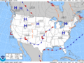
Coverage maps are designed to indicate the service areas of radiocommunication transmitting stations. Typically these may be produced for radio or television...
6 KB (731 words) - 19:04, 25 November 2024
act of Congress, and expanded it to the west coast soon afterwards. At first, not all the data on the map was used due to a lack of time standardization...
25 KB (2,826 words) - 23:21, 16 April 2025
Carthage (category Articles containing Ancient Greek (to 1453)-language text)
1963), text at 34, maps at 31 and 34. According to Harden, the outer walls ran several kilometres to the west of that indicated on the map here. Picard and...
113 KB (14,532 words) - 00:28, 3 August 2025

and a master index indicating the entirety of the mapped area and the sheet numbers for each large-scale map (usually depicting four to six blocks); and...
24 KB (2,613 words) - 19:38, 22 July 2025
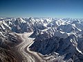
Karakoram (category Articles containing OSM location maps)
heights indicated on the Nepal Topographic Maps are followed. For China and the Baltoro Karakoram, the heights are those of Mi Desheng's "The Maps of Snow...
29 KB (2,552 words) - 05:28, 26 May 2025

relative to the axis of the Earth's orbit), in the top half. Maps are usually labelled to indicate which direction on the map corresponds to a direction...
14 KB (1,747 words) - 19:39, 13 May 2025

Surname maps are maps which display and indicate the highest concentration of residents with a particular surname, or set of surnames. This information...
1 KB (105 words) - 06:11, 21 December 2024

coastline for Asia distinct from the Americas, the Waldseemüller map apparently indicates the existence of a new ocean between the trans-Atlantic regions...
52 KB (7,181 words) - 02:34, 26 July 2025

New Guinea (category Wikipedia articles incorporating citation to the NSRW)
Archaeological evidence indicates that humans may have inhabited the island continuously since 50,000 BCE, and first settlement possibly dating back to 60,000 years...
66 KB (7,142 words) - 23:21, 23 July 2025
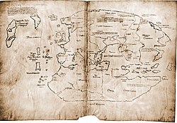
Map is a 20th-century forgery purporting to be a 15th-century mappa mundi with unique information about Norse exploration of North America. The map first...
40 KB (5,137 words) - 05:34, 10 June 2025
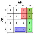
A Karnaugh map (KM or K-map) is a diagram that can be used to simplify a Boolean algebra expression. Maurice Karnaugh introduced the technique in 1953...
30 KB (3,588 words) - 17:11, 17 March 2025

Here be dragons (section Dragons on maps)
"Here be dragons" (Latin: hic sunt dracones) is a phrase used to indicate dangerous or unexplored territories, in imitation of a medieval practice of...
10 KB (1,115 words) - 10:06, 28 July 2025

father/son combinations to ever win the Australian Grand Prix. (key) (Races in bold indicate pole position) (Races in italics indicate fastest lap) Footnotes...
113 KB (4,245 words) - 14:06, 18 July 2025
on 8 March 2020. It is not known for certain when the horizontal line or lines, which indicate an abbreviation, first came to be drawn through the L....
42 KB (4,333 words) - 12:42, 31 July 2025
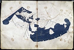
The Ptolemy world map is a map of the world known to Greco-Roman societies in the 2nd century. It is based on the description contained in Ptolemy's book...
7 KB (724 words) - 17:11, 27 January 2025
Wardley map, indicating that the service is closer to being a commodity. Other components are mapped similarly. For example, a drone operator needs to be aware...
15 KB (1,659 words) - 15:52, 1 August 2025

Guillaume Delisle (redirect from Map of Iran at the end of the Safavid period)
astronomy and measurement. When he could not confirm the accuracy of a source, he would indicate it clearly on his maps. For instance, his Carte de la Louisiane...
21 KB (2,711 words) - 17:14, 22 December 2024

by its publisher as belonging to the same series. Map series occur when an area is to be covered by a map that, due to its scale, must be spread over...
17 KB (2,087 words) - 00:41, 27 January 2024