King's Highway 58, commonly referred to as Highway 58, is a provincially maintained highway in the Canadian province of Ontario. The route is divided into...
20 KB (2,060 words) - 18:50, 26 March 2024
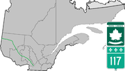
This is a List of Ontario Tourist Routes throughout the province, which are designated to highlight places of cultural, environmental, or social importance...
27 KB (2,929 words) - 14:58, 29 April 2023
List of secondary highways in Thunder Bay District (redirect from Ontario Route 527)
in the Canadian province of Ontario, which serves to connect the small community of Hurkett to Highway 17, the main route of the Trans-Canada Highway...
30 KB (1,905 words) - 15:53, 3 September 2023
List of secondary highways in Algoma District (redirect from Ontario Route 546)
populated areas in the Algoma District of northeastern Ontario. Some of the shorter ones are also access routes for communities with moderate amounts of tourism...
35 KB (2,703 words) - 03:04, 20 June 2024
the Quebec/Ontario border where it continues as Highway 66 east of McGarry, Ontario. It is an important road since it is the only direct route between southern...
18 KB (747 words) - 22:51, 13 May 2024
in the Canadian province of Ontario. Comprising a privately leased segment as well as a publicly owned segment, the route spans the entire Greater Toronto...
107 KB (8,333 words) - 08:30, 19 June 2024
58: European route E58 Riverina Highway Alberta Highway 58 Highway 58 (Ontario) Saskatchewan Highway 58 Finnish national road 58 National Highway 58,...
6 KB (383 words) - 23:09, 4 April 2024
as "Main Street Ontario" and was one of the first roads in what would later become Ontario. It was devised as an overland military route between York (Toronto)...
131 KB (9,529 words) - 22:24, 9 June 2024
maintained highway in the Canadian province of Ontario. Presently, it is a short 1.9 km (1.2 mi) stub between Highway 58 and Niagara Regional Road 70 in the City...
26 KB (1,918 words) - 08:22, 2 May 2024
County routes in Ontario County, New York, provide main arterial connections that are not otherwise provided by state highways. County routes never enter...
15 KB (190 words) - 16:54, 11 March 2022
List of numbered roads in Renfrew County (redirect from Ontario Route 508)
This is a list of numbered county roads in Renfrew County, Ontario, Canada....
17 KB (13 words) - 05:21, 26 April 2024
List of secondary highways in Kenora District (redirect from Ontario Route 116)
maintained secondary highway in the Canadian province of Ontario. Located in Kenora District, the route branches off Highway 17, the Trans-Canada Highway, between...
30 KB (2,153 words) - 02:37, 7 July 2023
List of secondary highways in Cochrane District (redirect from Ontario Route 572)
connecting Iroquois Falls, Ontario to Highway 11/Trans Canada Highway, and to Highway 101. This provides a very direct route for Timmins-Iroquois Falls...
18 KB (1,354 words) - 10:20, 11 August 2022
406, is a 400-series highway in the Canadian province of Ontario. The primary north–south route through the central portion of the Niagara Peninsula, Highway 406...
24 KB (1,949 words) - 06:24, 17 April 2024
Queen Elizabeth Way (redirect from Ontario Route QEW)
in Ontario, the QEW is directionally signed using locations along the route as opposed to cardinal directions. Driving towards Toronto, the route is signed...
95 KB (9,270 words) - 22:14, 19 June 2024

town in the Regional Municipality of Peel in the Greater Toronto Area of Ontario, Canada. The name comes from a shortened form of Caledonia, the Roman name...
37 KB (2,881 words) - 00:08, 14 May 2024
It is also a Core Route in the National Highway System of Canada. The route is maintained by the Ministry of Transportation of Ontario (MTO) and patrolled...
228 KB (16,185 words) - 04:49, 19 June 2024

Long Lake 58 First Nation (Ojibwe: Ginoogamaa-zaaga’igan 58) is an Anishinaabe (Ojibway) First Nation band government located in Northern Ontario, located...
13 KB (1,204 words) - 21:47, 5 May 2024

province of Ontario. At its peak, Highway 7 measured 716 km (445 mi) in length, stretching from Highway 40 east of Sarnia in Southwestern Ontario to Highway 17...
83 KB (5,116 words) - 19:12, 6 May 2024
List of secondary highways in Timiskaming District (redirect from Ontario Route 558)
province of Ontario. The highway is 7.6 kilometres (4.7 mi) in length, connecting Highway 112 in Dane with the now abandoned Adams Mine site. The route was designated...
17 KB (982 words) - 16:49, 10 April 2023
provincially maintained highway and the primary route of the Trans-Canada Highway through the Canadian province of Ontario. It begins at the Manitoba boundary, 50 km...
89 KB (6,792 words) - 16:28, 20 June 2024
List of secondary highways in Rainy River District (redirect from Ontario Route 600)
a secondary highway in the Canadian province of Ontario, located in Rainy River District. The route connects Highway 71 (the Trans-Canada Highway) with...
8 KB (525 words) - 15:52, 3 September 2023
maintained highway in the Canadian province of Ontario. The short route serves to connect Highway 58 with Highway 140 and passes beneath the Welland...
6 KB (537 words) - 18:53, 26 March 2024

Ontario. U.S. Route 53 also ends here. On the other side of the bridge, Trans-Canada Highway (Ontario Highway 11) is an east–west route while Ontario...
33 KB (3,488 words) - 01:41, 21 June 2024
the southwestern portion of the Canadian province of Ontario. The 91.4-kilometre (56.8 mi) route links Chatham and Sarnia via Wallaceburg, following close...
41 KB (3,728 words) - 21:06, 16 March 2024

enters rural southwestern Ontario, and is dominated by farmland for much of its length through Essex County. The now four-laned route becomes divided as it...
77 KB (6,465 words) - 17:47, 1 May 2024
Trans-Canada Highway (TCH), the Georgian Bay Route, and is part of the highest-capacity route from southern Ontario to the Canadian West, via a connection with...
81 KB (6,028 words) - 16:17, 24 June 2024
List of secondary highways in Parry Sound District (redirect from Ontario Route 559)
maintained secondary highway in the Canadian province of Ontario. It is a short and lightly travelled route that connects Highway 69 with the community of Britt...
25 KB (1,585 words) - 21:30, 1 September 2022
List of secondary highways in Manitoulin District (redirect from Ontario Route 540)
the isolated and sparsely populated areas in the Manitoulin District of Ontario. Secondary Highway 540, commonly referred to as Highway 540, is the primary...
11 KB (764 words) - 00:18, 19 June 2024

runs from its western terminus in Astoria to the Idaho border east of Ontario. West of Portland, US 30 generally follows the southern shore of the Columbia...
36 KB (2,200 words) - 22:34, 25 May 2024