King's Highway 7A, commonly referred to as Highway 7A, is a provincially maintained highway in the Canadian province of Ontario that serves as a bypass...
22 KB (2,304 words) - 17:53, 21 December 2023
List of secondary highways in Algoma District (redirect from Ontario Route 546)
populated areas in the Algoma District of northeastern Ontario. Some of the shorter ones are also access routes for communities with moderate amounts of tourism...
32 KB (2,521 words) - 21:20, 16 January 2024
in the Canadian province of Ontario. Comprising a privately leased segment as well as a publicly owned segment, the route spans the entire Greater Toronto...
107 KB (8,333 words) - 22:59, 19 May 2024
List of secondary highways in Cochrane District (redirect from Ontario Route 572)
connecting Iroquois Falls, Ontario to Highway 11/Trans Canada Highway, and to Highway 101. This provides a very direct route for Timmins-Iroquois Falls...
18 KB (1,354 words) - 10:20, 11 August 2022
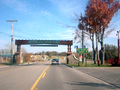
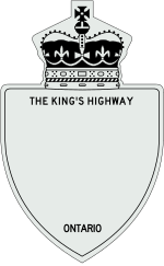
as "Main Street Ontario" and was one of the first roads in what would later become Ontario. It was devised as an overland military route between York (Toronto)...
131 KB (9,529 words) - 22:24, 9 June 2024
List of secondary highways in Thunder Bay District (redirect from Ontario Route 527)
in the Canadian province of Ontario, which serves to connect the small community of Hurkett to Highway 17, the main route of the Trans-Canada Highway...
30 KB (1,905 words) - 15:53, 3 September 2023

Toronto (redirect from Toronto Municipality, Ontario)
including Georgian Bay, Lake Simcoe, and several rivers. A portage route from Lake Ontario to Lake Huron running through this point, known as the Toronto...
255 KB (21,430 words) - 20:51, 9 June 2024

briefly separating the route into three discontinuous segments, but has since been rectified by renumbering a section of Highway 7A. From 2007 to 2012, the...
83 KB (5,116 words) - 19:12, 6 May 2024
From this point northeastward, Highway 115 is part of the southern Ontario route of the Trans-Canada Highway and concurrent with Highway 7. The freeway...
18 KB (1,151 words) - 17:42, 17 May 2024
List of secondary highways in Kenora District (redirect from Ontario Route 116)
maintained secondary highway in the Canadian province of Ontario. Located in Kenora District, the route branches off Highway 17, the Trans-Canada Highway, between...
30 KB (2,153 words) - 02:37, 7 July 2023
List of secondary highways in Timiskaming District (redirect from Ontario Route 558)
province of Ontario. The highway is 7.6 kilometres (4.7 mi) in length, connecting Highway 112 in Dane with the now abandoned Adams Mine site. The route was designated...
17 KB (982 words) - 16:49, 10 April 2023
It is also a Core Route in the National Highway System of Canada. The route is maintained by the Ministry of Transportation of Ontario (MTO) and patrolled...
227 KB (16,186 words) - 18:27, 16 June 2024
Provincial highways in Ontario include all roads maintained by the Ministry of Transportation as part of the Ontario Provincial Highway Network. Although...
118 KB (2,499 words) - 21:57, 27 February 2024
Queen Elizabeth Way (redirect from Ontario Route QEW)
in Ontario, the QEW is directionally signed using locations along the route as opposed to cardinal directions. Driving towards Toronto, the route is signed...
95 KB (9,203 words) - 01:31, 15 June 2024

Kawartha Lakes (redirect from City of Kawartha Lakes, Ontario)
Central Ontario, Canada. It is a municipality legally structured as a single-tier city; however, Kawartha Lakes is the size of a typical Ontario county...
43 KB (2,697 words) - 22:42, 8 May 2024
List of secondary highways in Rainy River District (redirect from Ontario Route 600)
a secondary highway in the Canadian province of Ontario, located in Rainy River District. The route connects Highway 71 (the Trans-Canada Highway) with...
8 KB (525 words) - 15:52, 3 September 2023

Pelee Island /ˈpiliː/ is an island in the Canadian province of Ontario. It is located in the western half of Lake Erie. At 42 km2 (16 sq mi), Pelee Island...
29 KB (2,440 words) - 18:49, 6 June 2024
List of secondary highways in Manitoulin District (redirect from Ontario Route 540)
the isolated and sparsely populated areas in the Manitoulin District of Ontario. Secondary Highway 540, commonly referred to as Highway 540, is the primary...
11 KB (764 words) - 22:20, 31 March 2021

List of numbered roads in Kawartha Lakes (redirect from Ontario Route 35A)
corner of the city; Highway 7A, an alternate route to Highway 7 around the Lindsay area; and Highway 7B, a business route through Lindsay. Provincially...
34 KB (1,428 words) - 18:52, 26 February 2024
Trans-Canada Highway (TCH), the Georgian Bay Route, and is part of the highest-capacity route from southern Ontario to the Canadian West, via a connection with...
81 KB (6,022 words) - 19:06, 16 June 2024
List of highways numbered 7 (redirect from State Route 7)
Brunswick Route 7 Northwest Territories Highway 7 Nova Scotia Trunk 7 Ontario Highway 7 York Regional Road 7 in Ontario Prince Edward Island Route 7 Saskatchewan...
12 KB (810 words) - 07:27, 30 April 2024
Highway Network consists of all the roads in Ontario maintained by the Ministry of Transportation of Ontario (MTO), including those designated as part of...
119 KB (11,363 words) - 08:06, 29 May 2024
border between the provinces of Ontario and Quebec, east of which the four lane freeway continues as Autoroute 40. The route proceeds west, south of the former...
62 KB (5,032 words) - 06:30, 17 April 2024

considered a spur route as it typically reconnects with another or the same major road. In the province of Ontario, most spur routes are designated as...
9 KB (1,140 words) - 07:41, 10 April 2024
smaller towns and communities. Once the primary east–west route across the southern portion of Ontario, most of Highway 2 was bypassed by Highway 401, which...
85 KB (5,555 words) - 07:21, 20 April 2024
Highway 2A Scarborough, Ontario – Was once an expressway in the 1940s until Highway 401 took over most of its current route in 1952. Windsor – Tilbury...
34 KB (3,672 words) - 21:30, 27 May 2024
the southwestern portion of the Canadian province of Ontario. The 91.4-kilometre (56.8 mi) route links Chatham and Sarnia via Wallaceburg, following close...
41 KB (3,728 words) - 21:06, 16 March 2024
List of secondary highways in Parry Sound District (redirect from Ontario Route 559)
maintained secondary highway in the Canadian province of Ontario. It is a short and lightly travelled route that connects Highway 69 with the community of Britt...
25 KB (1,585 words) - 21:30, 1 September 2022

Regional Municipality of Durham (redirect from Durham Region, Ontario)
informally referred to as Durham Region, is a regional municipality in Southern Ontario, Canada. Located east of Toronto and the Regional Municipality of York...
42 KB (3,311 words) - 16:30, 29 March 2024
Canadian province of Ontario that connects Highways 401 and 403 to Brampton. North of Brampton, the commuter freeway ends and the route becomes Highway 10...
34 KB (3,191 words) - 01:16, 19 April 2024