
example, colors can be used to indicate a classification of roads. These signs are usually explained in the margin of the map, or on a separately published...
20 KB (2,055 words) - 15:28, 25 May 2025

Nautical map Physical map Political map Relief map Resource map Road map Star map Street map Thematic map Topographic map Train track map Transit map Weather...
36 KB (4,374 words) - 12:48, 13 July 2025

References today to the Fuller projection or Dymaxion usually indicate this version. Unlike other polyhedral map projections, the Dymaxion map does not use a gnomonic...
13 KB (1,367 words) - 00:51, 12 July 2025
crowdsourced contributions to Google Maps were not discontinued as the company announced those features would be transferred to the Google Local Guides program...
164 KB (14,286 words) - 00:43, 17 July 2025
HTTP 404 (redirect from 404 File Not Found)
standard response code, to indicate that the browser was able to communicate with a given server, but the server could not find what was requested. The...
16 KB (1,945 words) - 23:09, 3 June 2025
allowed cartographers to estimate the extent of their geographical knowledge, and to indicate parts of the planet known to exist but not yet explored as terra...
73 KB (8,596 words) - 00:42, 2 July 2025
informational purposes and are of use to passengers for selection of their seat at booking or check-in. Seat maps usually indicate the basic seating layout; the...
7 KB (957 words) - 23:18, 16 April 2025
1964–1970 Since 1970 the map has used a reversed (red on white) British Rail "double arrow" beside the station name to indicate main line interchanges....
73 KB (6,157 words) - 12:37, 12 June 2025

classification is BS (semi-arid: steppe climate). A third letter can be included to indicate temperature. Here, h signifies low-latitude climates (average annual...
60 KB (6,961 words) - 00:13, 7 July 2025

An emergency position-indicating radiobeacon (EPIRB) is a type of emergency locator beacon for commercial and recreational boats; it is a portable, battery-powered...
86 KB (10,208 words) - 07:25, 3 July 2025
Mercator projection (redirect from Mercator map projection)
generally not believed to be based on any deliberate map projection, included windrose networks of criss-crossing lines which could be used to help set...
49 KB (6,858 words) - 10:56, 5 June 2025
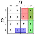
A Karnaugh map (KM or K-map) is a diagram that can be used to simplify a Boolean algebra expression. Maurice Karnaugh introduced the technique in 1953...
30 KB (3,588 words) - 17:11, 17 March 2025

The use of N to indicate "none" long survived in the historic apothecaries' system of measurement: used well into the 20th century to designate quantities...
75 KB (7,544 words) - 08:44, 4 July 2025
the formation of deep and long gullies. Inactive does not necessarily indicate the volcano will not erupt again. Mount Pinatubo had no recorded historical...
64 KB (341 words) - 09:08, 3 July 2025

Pictorial maps (also known as illustrated maps, panoramic maps, perspective maps, bird's-eye view maps, and geopictorial maps) depict a given territory...
13 KB (1,595 words) - 19:44, 26 June 2025

Constellation (section Atlases and celestial maps)
large map chart depicting the constellations of the heavens; as a special supplement to the August 1970 issue of National Geographic. Forerunner map as A...
55 KB (5,807 words) - 21:50, 16 July 2025

Illinois and California voting more Republican than in 2020. Polling had indicated a potentially closer race in New York in 2024 than in 2016 or 2020, but...
94 KB (2,413 words) - 13:01, 3 July 2025

The Babylonian Map of the World (also Imago Mundi or Mappa mundi) is a Babylonian clay tablet with a schematic world map and two inscriptions written...
17 KB (1,692 words) - 16:38, 28 June 2025
List of United States presidential election results by state (redirect from United States presidential election maps)
who pledge to vote for a specific political party's nominee for president. Bold italic text indicates the winner of the election ‡ indicates the winner...
282 KB (263 words) - 04:42, 25 April 2025
act of Congress, and expanded it to the west coast soon afterwards. At first, not all the data on the map was used due to a lack of time standardization...
25 KB (2,826 words) - 23:21, 16 April 2025
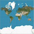
This usually involves the use of map symbols to visualize selected properties of geographic features that are not naturally visible, such as temperature...
28 KB (3,084 words) - 15:29, 26 May 2025

as an aid for Wikiphotographers. It shows a map of nearby national heritage register items, indicating whether Wikipedia had a photo for the site, and...
13 KB (748 words) - 15:38, 13 July 2025

likely used to provide context for the Bible's stories as well as a visual narrative of Christianity. Mappae mundi were not utilized as maps for travel...
10 KB (1,416 words) - 15:18, 24 May 2025

Elevation (section Maps and GIS)
data for spatial analysis or cartography. A topographical map is the main type of map used to depict elevation, often through contour lines. In a Geographic...
6 KB (561 words) - 17:58, 4 May 2025

New Guinea (category Wikipedia articles incorporating citation to the NSRW)
Archaeological evidence indicates that humans may have inhabited the island continuously since 50,000 BCE, and first settlement possibly dating back to 60,000 years...
66 KB (7,142 words) - 03:45, 2 June 2025
Waze (redirect from FreeMap Israel)
License v2, which did not extend to map data. The base map data initially came from US Census Bureau TIGER data. FreeMap data was not published under open...
36 KB (3,657 words) - 14:44, 26 June 2025
transcribing sounds (phones), not phonemes, though it is used for phonemic transcription as well. A few letters that did not indicate specific sounds have been...
172 KB (16,740 words) - 20:17, 17 July 2025

Hash table (redirect from Hash map)
and the resulting hash indicates where the corresponding value is stored. A map implemented by a hash table is called a hash map. Most hash table designs...
54 KB (6,078 words) - 16:13, 17 July 2025

Map, also known as the Madaba Mosaic Map, is part of a floor mosaic in the early Byzantine church of Saint George in Madaba, Jordan. The mosaic map depicts...
19 KB (2,084 words) - 12:54, 29 May 2025