 | The Geospatial Information Authority of Japan (国土地理院, Kokudo Chiri-in), or GSI, is the national institution responsible for surveying and mapping the... 6 KB (598 words) - 21:22, 10 January 2024 |
 | 2015-08-20. Archived from the original on 2016-08-20. "座標変換ソフトウェア TKY2JGD|国土地理院". www.gsi.go.jp. Archived from the original on 2017-11-05. Yang, H.; Lee... 29 KB (3,073 words) - 16:06, 31 December 2023 |
 | National Archive, The Hague, Archive of Consulat Yokohama No. 3 and 4 "地理院地図 / GSI Maps|国土地理院". maps.gsi.go.jp. Retrieved 20 August 2020. US Department of State... 70 KB (7,747 words) - 20:56, 22 April 2024 |
 | spiritual Mount Tateyama". InsideJapan Tours. Retrieved April 22, 2022. "地理院地図|国土地理院". Fay, Tom; Lang, Wes (2019-03-27). Hiking and Trekking in the Japan... 9 KB (576 words) - 20:11, 26 March 2024 |
 | ni 1. 3 Mētoru idō kokudo chiri-in ga zantei-chi" 石川県輪島市、地震で西に1.3メートル移動 国土地理院が暫定値 [Wajima City, Ishikawa Prefecture, moved 1.3 meters west due to earthquake;... 238 KB (22,882 words) - 18:08, 2 May 2024 |
 | Activities Sasebo Western Army (Japan) "平成28年全国都道府県市区町村別面積調 島面積" (PDF). 国土地理院. 2016-10-01. Retrieved 2017-02-27. "Kujū-san, Japan". Peakbagger.com. "離島とは(島の基礎知識)... 21 KB (1,915 words) - 00:36, 19 April 2024 |
 | and fertilizer production. 平成21年面積 全国都道府県市区町村別面積調 国土地理院 (in Japanese) 平成21年面積 全国都道府県市区町村別面積調 国土地理院 世帯および男女別人口(全人口)-全国,道府県,郡,市区町村 昭和15年国勢調査 政府統計の総合窓口 v... 3 KB (226 words) - 16:13, 16 March 2024 |
 | registered in UNESCO World Heritage Site as "Yakushima". Miyanoura 日本の主な山岳標高:鹿児島県(国土地理院、2010年12月28日閲覧) Media related to Mount Miyanoura at Wikimedia Commons... 1 KB (76 words) - 13:47, 23 August 2023 |
 | Ethnologue (25th ed., 2022) Noguchi 2001, p. 76. "平成17年 全国都道府県市区町村別面積調" (PDF). 国土地理院. 1 October 2005. p. 189. Archived from the original (PDF) on 20 January... 62 KB (5,750 words) - 02:49, 23 April 2024 |
 | mētoru ijō ryūki ― kokudo chiri-in ga kōkai" 硫黄島新地図、面積1.3倍 火山活動で8メートル以上隆起―国土地理院が公開 [New map of Iwo Jima, area 1.3 times larger, raised more than 8 meters... 52 KB (5,657 words) - 11:53, 23 April 2024 |
 | Retrieved January 27, 2019.") (in Japanese)") (in Japanese) "国土地理院ニュースレター 月刊GSIマップニュース 第86号" (PDF). 国土地理院. 1999-11-25. Retrieved January 27, 2019. ("'Geographical... 24 KB (2,765 words) - 11:49, 27 April 2024 |
 | Retrieved 17 November 2021. "ながの". NHK日本語発音アクセント新辞典. NHK. 長野県庁(画面左下に標高表示) - 国土地理院地図 市政情報 > 市の沿革・概要 > 人口・面積・自然 (in Japanese). Hanazawa, Nahomi (1999). Official... 76 KB (6,215 words) - 07:40, 19 April 2024 |
 | official statistics(in Japanese) 関義治、大野博之「海から最も遠い地点の探索」、『地図管理部技術報告(国土地理院技術資料E3)』第4巻、国土地理院、1997年、 47-50頁。 気象庁 / 平年値(年・月ごとの値). JMA. Retrieved April 20, 2022... 24 KB (2,026 words) - 01:11, 31 March 2024 |
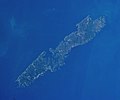
 | Ogi subdivision. Sado, Niigata (municipality) 島面積20傑 (PDF) (in Japanese). 国土地理院. Retrieved 2017-07-08. [permanent dead link] 佐渡島の概況 (in Japanese). 新潟県.... 34 KB (2,734 words) - 21:46, 2 April 2024 |
 | described. 田代博、藤本一美、清水長正、高田将志 『山の地図と地形』 山と渓谷社、1996年 日本の主な山岳標高 都道府県別最高地点の一覧(国土地理院) 『山の便利手帳2001』山と渓谷2001年1月号第786号付録、山と渓谷社、2001年、P350 The highest point of Akita... 10 KB (278 words) - 08:56, 2 April 2023 |
 | Interactions between Nature and People. pp 119-120. ISBN 978-94-007-1783-1 国土地理院 平成29年全国都道府県市区町村別面積調 付1 湖沼面積(平成29年10月1日版) 2018年2月10日閲覧。 Murray, N.J.; Phinn... 148 KB (14,669 words) - 22:34, 22 April 2024 |
 | as Tanzawa-Ōyama National Monument. "Mount Omuro, Japan". Peakbagger.com. Retrieved 2021-02-21. "標高値を改定する山岳一覧 資料2" (PDF). 国土地理院. Retrieved 2014-03-26.... 1 KB (84 words) - 16:24, 4 June 2021 |
 | (PDF). 国土地理院. Retrieved 2014-03-26. GNSS測量等の点検・補正調査による2014年4月1日の国土地理院『日本の山岳標高一覧-1003山-』における改定値。なお、旧版での標高は1,980m。 日本山岳会『新日本山岳誌』ナカニシヤ出版、2005年 国土地理院 基準点成果等閲覧サービス... 5 KB (534 words) - 23:41, 20 October 2023 |
 | Japan Parent range Akaishi Mountains Topo map Geographical Survey Institute (国土地理院, Kokudochiriin) 25000:1 仙丈ヶ岳, 50000:1 市野瀬 Climbing Easiest route Hike... 4 KB (236 words) - 20:05, 14 November 2023 |
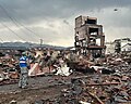
 | 津波による浸水範囲の面積(概略値)について(第5報) (PDF) (in Japanese). Geospatial Information Authority in Japan(国土地理院). 18 April 2011. Archived (PDF) from the original on 23 June 2011. Retrieved... 237 KB (22,317 words) - 17:39, 12 April 2024 |
 | Jōmon sites. List of volcanoes in Japan List of mountains in Japan "地理院地図 / GSI Maps|国土地理院" [GSI Maps | Geospatial Information Authority of Japan]. Geospatial... 8 KB (745 words) - 08:44, 23 April 2024 |
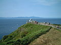 | Peninsula in Hokkaido across the Tsugaru Strait can be seen from this location. 国土地理院の地形図 [Geospatial Information Authority Topographic Map] (Map) (in Japanese)... 3 KB (228 words) - 06:13, 21 August 2023 |
 | seen from Mount Suisho. Chūbu-Sangaku National Park "日本の主な山岳標高(富山県の山)". 国土地理院. Retrieved 2010-01-05. 深田久弥 (1982). 日本百名山. 朝日新聞出版. pp. 202–205. ISBN 4-02-260871-4... 3 KB (189 words) - 02:57, 10 September 2023 |
 | original on 2009-12-18. Retrieved 2012-12-16. "石川県能登半島沖を震源とする地震に伴う地殻変動(第1報)|国土地理院". Gsi.go.jp. Retrieved 2017-06-08. "Learning from Earthquakes: Noto Peninsula... 20 KB (1,562 words) - 09:02, 15 April 2024 |
 | means "river spawning salmon and trout." There is a mountain of the same name "Ichankoppesan" nearby. 国土地理院 基準点成果等閲覧サービス 『山渓カラー名鑑 日本の山1000』山と渓谷社、1992年... 2 KB (113 words) - 02:47, 9 August 2023 |
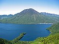
 | Parent range Nasu Volcanic Zone Topo map Geographical Survey Institute (国土地理院, Kokudochiriin) 50000:1 樽前山, 25000:1 樽前山, 25000:1 風不死岳 Geology Mountain... 5 KB (319 words) - 18:53, 3 January 2024 |
Jamaica National Spatial Data Management Division (NSDMD) mwh.gov.jm Japan 国土地理院 Geospatial Information Authority of Japan (GSI) gsi.go.jp GSI maps Jordan... 29 KB (148 words) - 20:20, 25 March 2024 |
 | Ushirotateyama mountain range. "基準点成果等閲覧サービス". 国土地理院. Retrieved 2013-04-19. "日本の主な山岳標高(富山県・長野県)". 国土地理院. Retrieved 2013-04-19. 新日本山岳誌 (2005)、886-887頁 "中部山岳国立公園の区域図"... 3 KB (116 words) - 07:32, 25 December 2023 |
 | (Hokkaido) Show map of Hokkaido Topo map Geographical Survey Institute (国土地理院, Kokudochiriin) 25000:1 風不死岳, 25000:1 樽前山, 50000:1 樽前山 Geology Age of rock... 2 KB (141 words) - 20:02, 24 June 2022 |
 | Parent range Nasu Volcanic Zone Topo map Geographical Survey Institute (国土地理院, Kokudochiriin) 25000:1 恵庭岳, 50000:1 樽前山 Geology Age of rock Holocene Mountain... 5 KB (456 words) - 11:42, 9 May 2023 |