 | Route 153 is a national highway of Japan connecting Higashi-ku, Nagoya and Shiojiri, Nagano in Japan, with a total length of 213.4 km (132.6 mi). "一般国道の路線別、都道府県別道路現況"... 1 KB (73 words) - 11:45, 17 June 2022 |
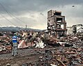
 | National Route 340 (国道340号, Kokudō Sanbyakuyonjūgō) is a national highway of Japan connecting the cities of Rikuzentakata, in southeastern Iwate Prefecture... 10 KB (168 words) - 10:13, 7 August 2023 |
National Route 19 (国道19号, Kokudō jūkyū-gō) is a national highway connecting Nagoya and Nagano in Japan. Length: 258.9 km (165.5 mi) Origin: Atsuta-ku... 5 KB (380 words) - 02:04, 18 March 2024 |
 | National Route 20 (国道20号, Kokudō nijū-gō) is a national highway connecting Tokyo and Shiojiri, Nagano prefecture in Japan. Originating at Nihonbashi in... 5 KB (441 words) - 02:05, 18 March 2024 |
National Route 1 (国道1号, Kokudō Ichi-gō) is a major highway on the island of Honshū in Japan. It connects Chūō, Tokyo in the Kantō region with the city... 66 KB (842 words) - 18:28, 8 December 2023 |
 | National Route 7 (国道7号, Kokudō Nanagō) is a major north-south national highway on the Sea of Japan side of the island of Honshū, Japan. It traverses four... 35 KB (473 words) - 01:55, 18 March 2024 |
National Route 4 (国道4号, Kokudō Yongō) is a major national highway in eastern Honshū, Japan. Measuring 738.5 kilometers long (458.9 mi), it is the longest... 70 KB (1,026 words) - 17:40, 6 August 2023 |
National Route 339 (国道339号, Kokudō Sanbyaku san-jukyūgō) is a national highway of Japan that traverses the western side of Aomori Prefecture, traveling... 14 KB (805 words) - 09:30, 7 August 2023 |
National Route 58 (国道58号, Kokudō Gojūhachi-gō) is a Japanese national highway connecting the capital cities Kagoshima and Naha of Kagoshima Prefecture... 30 KB (1,850 words) - 21:42, 17 March 2024 |
 | National Route 238 (国道238号, Kokudō Nihyaku sanjūhachi-gō) is the northernmost of the national highways of Japan. It connects the cities of Abashiri and... 9 KB (207 words) - 22:57, 25 June 2023 |
 | doshakuzure kokudō 8-gō fukkyū mitōshi tatazu Nīgata Jōetsu" 能登半島地震で土砂崩れ 国道8号 復旧見通し立たず 新潟 上越 [Landslide caused by Noto Peninsula earthquake, National Route... 238 KB (22,866 words) - 20:47, 24 April 2024 |
National Route 5 (国道5号, Kokudō Go-gō) is a major highway on the island and prefecture of Hokkaido in northern Japan. The 288.5-kilometer (179.3 mi) highway... 17 KB (400 words) - 19:13, 11 March 2024 |
National Route 395 (国道395号, Kokudō Kokudō Sanbyakukyūjūgo-gō) is a Japanese national highway connecting the cities of Kuji and Ninohe. The 58.0-kilometer-long... 6 KB (255 words) - 10:49, 7 August 2023 |
 | Shinshiro, Aichi in Japan, with a total length of 66.5 km (41.32 mi). "一般国道の路線別、都道府県別道路現況" [Road statistics by General National Highway route and prefecture]... 1 KB (72 words) - 03:06, 21 March 2024 |
 | Miyazu, Kyoto and Himeji, Hyōgo in Japan, with a total length of 153.5 km (95.38 mi). "一般国道の路線別、都道府県別道路現況" [Road statistics by General National Highway route... 1 KB (72 words) - 08:35, 20 March 2024 |
inner loop and runs concurrent with much of the Mei-Nikan Expressway. "一般国道の路線別、都道府県別道路現況" [Road statistics by General National Highway route and prefecture]... 2 KB (90 words) - 08:27, 20 March 2024 |
 | with TB instead of an exit number. There are currently no service areas. "一般国道の路線別、都道府県別道路現況" [Road statistics by General National Highway route and prefecture]... 5 KB (126 words) - 10:41, 27 April 2024 |
Gamagōri and Makinohara in Japan. It has a total length of 247.8 km (153.98 mi). "一般国道の路線別、都道府県別道路現況" [Road statistics by General National Highway route... 1 KB (71 words) - 18:59, 21 March 2024 |
 | connecting Abashiri and Nemuro in Japan, with a total length of 153.9 km (95.63 mi). "一般国道の路線別、都道府県別道路現況" [Road statistics by General National Highway route... 1 KB (70 words) - 19:42, 26 March 2024 |
with a total length of 99.2 km (61.6 mi). Japan portal Roads portal "一般国道の路線別、都道府県別道路現況" [Road statistics by General National Highway route and prefecture]... 1 KB (77 words) - 08:26, 20 March 2024 |
 | and Atsuta-ku, Nagoya in Japan, with a total length of 4 km (2.49 mi). "一般国道の路線別、都道府県別道路現況" [Road statistics by General National Highway route and prefecture]... 1 KB (73 words) - 02:32, 22 March 2024 |
 | with a total length of 252.4 km (156.8 mi). Japan portal Roads portal "一般国道の路線別、都道府県別道路現況" [Road statistics by General National Highway route and prefecture]... 2 KB (77 words) - 02:59, 26 December 2022 |
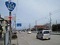
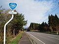 | National Route 280 (国道280号, Kokudō Nihyaku hachi-jugō) is a national highway of Japan that traverses the prefectures, Aomori and Hokkaido as well as the... 11 KB (712 words) - 12:03, 7 August 2023 |
 | 2015. "国頭林道2ヵ所、台風で土砂崩れ 東村国道、復旧進まず". Ryūkyū Shimpō (in Japanese). July 28, 2015. Retrieved December 23, 2015. 平成27年台風第12号による大雨等に係る被害状況等について (PDF) (Report)... 30 KB (3,048 words) - 23:32, 23 August 2023 |
349 and 400 in Niigata Prefecture Routes 7, 8, 290, 403, 459 and 460 "一般国道の路線別、都道府県別道路現況" [Road statistics by General National Highway route and prefecture]... 3 KB (157 words) - 02:40, 18 March 2024 |
 | c.nishinippon.co.jp (in Japanese). Retrieved 2020-05-09. "昭和46年8月洪水". 八代河川国道事務所. Retrieved 2020-06-29. "78 Dead in Storm's Wake In Japan and South Korea"... 17 KB (1,994 words) - 20:51, 13 September 2023 |