 | with a total length of 86.4 km (53.7 mi) Japan portal Roads portal "一般国道の路線別、都道府県別道路現況" [Road statistics by General National Highway route and prefecture]... 1 KB (76 words) - 03:17, 26 December 2022 |
National Route 8 (国道8号, Kokudō hachi-gō) is a major highway in the Hokuriku and Kansai regions of central Japan. The 574.1-kilometer (356.7 mi) highway... 8 KB (524 words) - 01:56, 18 March 2024 |
 | National Route 7 (国道7号, Kokudō Nanagō) is a major north-south national highway on the Sea of Japan side of the island of Honshū, Japan. It traverses four... 35 KB (473 words) - 01:55, 18 March 2024 |
National Route 1 (国道1号, Kokudō Ichi-gō) is a major highway on the island of Honshū in Japan. It connects Chūō, Tokyo in the Kantō region with the city... 66 KB (842 words) - 18:28, 8 December 2023 |
National Route 4 (国道4号, Kokudō Yongō) is a major national highway in eastern Honshū, Japan. Measuring 738.5 kilometers long (458.9 mi), it is the longest... 70 KB (1,026 words) - 17:40, 6 August 2023 |
National Route 58 (国道58号, Kokudō Gojūhachi-gō) is a Japanese national highway connecting the capital cities Kagoshima and Naha of Kagoshima Prefecture... 30 KB (1,850 words) - 21:42, 17 March 2024 |
 | National Route 396 (国道396号, Kokudō 396-gō) is a national highway of Japan connecting Tōno, Iwate and Morioka, Iwate in Japan, with a total length of 58... 3 KB (355 words) - 21:43, 20 March 2024 |
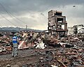
 | National Route 283 (国道283号, Kokudō 283-gō) is a national highway connecting Kamaishi, Iwate and Hanamaki, Iwate in Japan, with a total length of 89.3 km... 4 KB (499 words) - 01:04, 18 March 2024 |
 | doshakuzure kokudō 8-gō fukkyū mitōshi tatazu Nīgata Jōetsu" 能登半島地震で土砂崩れ 国道8号 復旧見通し立たず 新潟 上越 [Landslide caused by Noto Peninsula earthquake, National Route... 238 KB (22,866 words) - 20:47, 24 April 2024 |
"新突破!城开高速控制性工程吴家梁隧道掘进4000米大关_高速公路". www.sohu.com. Retrieved 2020-10-11. "国道109新线饮马鞍隧道开挖进尺突破4000米!". j.021east.com. Retrieved 2022-05-22. 网易 (2021-09-11)... 122 KB (3,503 words) - 12:51, 19 April 2024 |
National Route 350 (国道350号, Kokudō Sanbyaku gojūgō) is a national highway of Japan that traverses the prefecture of Niigata in a southwest–northeast routing... 11 KB (559 words) - 12:12, 7 August 2023 |
"新突破!城开高速控制性工程吴家梁隧道掘进4000米大关_高速公路". www.sohu.com. Retrieved 2020-10-11. "国道109新线饮马鞍隧道开挖进尺突破4000米!". j.021east.com. Retrieved 2022-05-22. "景文3标项目叶麻尖1#隧道顺利进洞施工"... 104 KB (2,809 words) - 20:26, 31 December 2023 |
 | with a total length of 45.8 km (28.5 mi). Japan portal Roads portal "一般国道の路線別、都道府県別道路現況" [Road statistics by General National Highway route and prefecture]... 2 KB (76 words) - 03:18, 26 December 2022 |
 | Hokkaidō and Urakawa, Hokkaidō in Japan, with a total length of 260 km (161.56 mi). "一般国道の路線別、都道府県別道路現況" [Road statistics by General National Highway route... 1 KB (71 words) - 22:29, 17 March 2024 |
 | April 1982, the road was extended to Tsuruga. Japan portal Roads portal "一般国道の路線別、都道府県別道路現況" [Road statistics by General National Highway route and prefecture]... 2 KB (97 words) - 19:39, 10 December 2023 |
 | alongside the Nobori River in Minamiuonuma is closed during the Winter. "一般国道の路線別、都道府県別道路現況" [Road statistics by General National Highway route and prefecture]... 2 KB (165 words) - 19:53, 19 October 2023 |