this was redesignated as Route 54 when the route was promoted to a Class 1 highway. Length: 174.5 km (108.43 mi). "一般国道の路線別、都道府県別道路現況" [Road statistics... 2 KB (96 words) - 02:45, 18 March 2024 |
National Route 1 (国道1号, Kokudō Ichi-gō) is a major highway on the island of Honshū in Japan. It connects Chūō, Tokyo in the Kantō region with the city... 66 KB (842 words) - 18:28, 8 December 2023 |
 | National Route 2 (国道2号, Kokudō Ni-gō) is a major highway on the islands of Honshū and Kyūshū in Japan. It follows the old Sanyōdo westward from the city... 4 KB (308 words) - 01:53, 18 March 2024 |
National Route 55 (国道55号, Kokudō Gojūgogō) is a national highway of Japan connecting the capitals of Tokushima and Kōchi prefectures, Tokushima and Kōchi... 5 KB (402 words) - 21:15, 15 March 2024 |
 | National Route 7 (国道7号, Kokudō Nanagō) is a major north-south national highway on the Sea of Japan side of the island of Honshū, Japan. It traverses four... 35 KB (473 words) - 01:55, 18 March 2024 |
National Route 4 (国道4号, Kokudō Yongō) is a major national highway in eastern Honshū, Japan. Measuring 738.5 kilometers long (458.9 mi), it is the longest... 70 KB (1,026 words) - 17:40, 6 August 2023 |
National Route 12 (国道12号, Kokudō Jūni-gō) is a Japanese national highway connecting the two largest cities of Hokkaido, Sapporo and Asahikawa. The 135... 20 KB (924 words) - 02:01, 18 March 2024 |
 | National Route 238 (国道238号, Kokudō Nihyaku sanjūhachi-gō) is the northernmost of the national highways of Japan. It connects the cities of Abashiri and... 9 KB (207 words) - 22:57, 25 June 2023 |
 | National Route 282 (国道282号, Kokudō Nihyakuhachijūnigō) is a national highway of Japan connecting the cities of Morioka, the capital city of Iwate Prefecture... 9 KB (376 words) - 01:00, 18 March 2024 |
 | National Route 308 (国道308号, Kokudō Sanbyaku-hachi-gō) is a national highway of Japan connecting Chūō-ku, Osaka and Nara, with a total length of 32.9 kilometers... 3 KB (124 words) - 08:33, 20 March 2024 |
 | National Route 340 (国道340号, Kokudō Sanbyakuyonjūgō) is a national highway of Japan connecting the cities of Rikuzentakata, in southeastern Iwate Prefecture... 10 KB (168 words) - 10:13, 7 August 2023 |
National Route 105 (国道105号, Kokudō Hyaku gogō) is a national highway of Japan that traverses the prefecture of Akita in a southwest–northeast routing.... 14 KB (746 words) - 18:56, 11 March 2024 |
 | National Route 394 (国道394号, Kokudō San hyaku kyū jūyongō) is a national highway in the Japanese prefecture of Aomori. Route 394 stretches 185 km (115 miles)... 7 KB (382 words) - 08:21, 13 January 2023 |
National Route 465 (国道465号, Kokudō Yonhyaku roku-jūgogō) is a national highway located entirely within Chiba Prefecture, Japan. It connects the cities... 16 KB (841 words) - 17:44, 6 August 2023 |
National Route 114 (国道114号, Kokudō Hyaku jūyongō) is a national highway of Japan that traverses the prefecture of Fukushima in a northwest–southeast routing... 11 KB (798 words) - 09:28, 7 August 2023 |
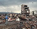 | doshakuzure kokudō 8-gō fukkyū mitōshi tatazu Nīgata Jōetsu" 能登半島地震で土砂崩れ 国道8号 復旧見通し立たず 新潟 上越 [Landslide caused by Noto Peninsula earthquake, National Route... 238 KB (22,882 words) - 18:08, 2 May 2024 |
National Route 410 (国道410号, Kokudō Yonhyakujūgō) is a national highway located entirely within Chiba Prefecture, Japan. It connects the cities of Tateyama... 15 KB (516 words) - 17:43, 6 August 2023 |
National Route 48 (国道48号, Kokudō yonjūhachigō) is a national highway of Japan that connects the capital cities of Miyagi Prefecture and Yamagata Prefecture... 10 KB (617 words) - 22:32, 6 August 2023 |
National Route 7 国道7号 Aomori Belt Highway 青森環状道路 (Aomori Kanjō-dōro) Route information Length 16.6 km (10.3 mi) Component highways National Route 7 Major... 7 KB (544 words) - 16:51, 21 April 2023 |
National Route 39 (国道39号, Kokudō Sanjūkyū-gō) is a Japanese national highway connecting the two cities of Asahikawa and Abashiri in northeastern Hokkaido... 16 KB (503 words) - 16:50, 15 March 2024 |
"新突破!城开高速控制性工程吴家梁隧道掘进4000米大关_高速公路". www.sohu.com. Retrieved 2020-10-11. "国道109新线饮马鞍隧道开挖进尺突破4000米!". j.021east.com. Retrieved 2022-05-22. 网易 (2021-09-11)... 122 KB (3,503 words) - 12:51, 19 April 2024 |
 | while traveling on Route 353 through Nakanojō" 【歌詞付】いつも何度でも【メロディーロード】群馬県中之条町国道353号. YouTube. Archived from the original on 2021-12-22. Retrieved June 10, 2020... 14 KB (738 words) - 08:07, 30 March 2024 |
National Route 112 (国道112号, Kokudō Hyaku jūnigō) is a national highway of Japan that traverses the prefecture of Yamagata in a southeast–northwest routing... 18 KB (459 words) - 22:34, 6 August 2023 |
 | The Wall Street Journal. Retrieved 20 August 2020. "三天四夜,他们打通文县212国道"生命线" 文县公路段抢修国道212线公路侧记-甘肃-每日甘肃网". gansu.gansudaily.com.cn. Archived from the original... 75 KB (7,776 words) - 11:22, 23 April 2024 |
total length of 54 km (33.55 mi). Route 302 serves as Nagoya's inner loop and runs concurrent with much of the Mei-Nikan Expressway. "一般国道の路線別、都道府県別道路現況"... 2 KB (90 words) - 08:27, 20 March 2024 |
link] "国社@四川|乐西高速大凉山1号、2号隧道掘进施工进展顺利-新华网". www.sc.xinhuanet.com. Archived from the original on October 9, 2021. Retrieved 2021-10-09. "54%!武九高速公路控制性工程高楼山特长隧道最新进展_施工"... 104 KB (2,809 words) - 20:26, 31 December 2023 |
 | Ishikawa and Yokkaichi, Mie in Japan, with a total length of 229.4 km (142.54 mi). "一般国道の路線別、都道府県別道路現況" [Road statistics by General National Highway route and... 1 KB (72 words) - 21:21, 20 March 2024 |
National Freeway 1 Traditional Chinese 國道1號 Simplified Chinese 国道1号 Sun Yat-sen Freeway Chinese 中山高速公路... 28 KB (459 words) - 08:14, 21 August 2022 |
 | Okayama and Matsue in Japan, with a total length of 198.9 km (123.6 mi). "一般国道の路線別、都道府県別道路現況" [Road statistics by General National Highway route and prefecture]... 2 KB (70 words) - 21:06, 17 March 2024 |
 | 1953 from Hiroshima to Matsue. This was redesignated as Route 54 on 1 April 1963. "一般国道の路線別、都道府県別道路現況" [Road statistics by General National Highway route... 2 KB (93 words) - 19:12, 19 March 2024 |