 | 緑区 247,475 37.91 6,528 7 Minami-ku 南区 136,015 18.46 7,368 8 Minato-ku 港区 143,913 45.64 3,153 9 Mizuho-ku 瑞穂区 107,622 11.22 9,592 10 Moriyama-ku 守山区 176... 94 KB (8,319 words) - 14:36, 5 May 2024 |
 | Moriyama (守山区, Moriyama-ku) is one of the wards of the city of Nagoya in Aichi Prefecture, Japan. As of 1 October 2019, the ward has an estimated population... 8 KB (360 words) - 01:48, 25 February 2024 |
 | A ward (区, ku) is a subdivision of the cities of Japan that are large enough to have been designated by government ordinance. Wards are used to subdivide... 33 KB (194 words) - 20:06, 1 May 2024 |
 | Setagaya (世田谷区, Setagaya-ku, officially called Setagaya City or the City of Setagaya) is a special ward in the Tokyo Metropolis in Japan. It is also the... 32 KB (2,649 words) - 11:47, 24 March 2024 |
17264. National Printing Bureau. p. 5. 金慶末(堀慶末、橋本慶末)昭和50年4月29日生 住所:名古屋市守山区大字小幡字米野92番地 Hori. p. 11. Hori. p. 12. Hori. p. 13. Hori. p. 14. Hori. p. 15... 31 KB (4,395 words) - 10:45, 14 October 2023 |
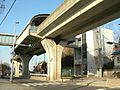
 | Moriyama Station (守山駅, Moriyama-eki) is a guided bus station in Moriyama-ku, Nagoya, Aichi Prefecture, Japan. Nagoya Guideway Bus Yutorīto Line (Station... 1 KB (29 words) - 01:31, 21 May 2020 |
 | Station) General information Location Ōmaki-chō, Moriyama, Nagoya, Aichi (名古屋市守山区大牧町) Japan Coordinates 35°12′09″N 136°57′24″E / 35.202527°N 136.956741°E... 2 KB (54 words) - 01:54, 14 July 2020 |
 | General information Location Ryūsenji 2-chōme, Moriyama, Nagoya, Aichi (名古屋市守山区竜泉寺二丁目) Japan Coordinates 35°13′07″N 136°58′58″E / 35.218746°N 136.982898°E... 1 KB (32 words) - 23:35, 20 May 2020 |
 | General information Location Matsukasa-chō, Moriyama, Nagoya, Aichi (名古屋市守山区松坂町) Japan Coordinates 35°12′57″N 136°58′43″E / 35.215963°N 136.978521°E... 2 KB (32 words) - 21:35, 20 May 2020 |
 | General information Location Kawamura-chō, Moriyama, Nagoya, Aichi (名古屋市守山区川村町) Japan Coordinates 35°12′51″N 136°58′07″E / 35.21421°N 136.968699°E... 2 KB (29 words) - 13:29, 21 May 2020 |
 | General information Location Kawamiya-chō, Moriyama, Nagoya, Aichi (名古屋市守山区川宮町) Japan Coordinates 35°12′37″N 136°57′43″E / 35.210278°N 136.962°E /... 2 KB (29 words) - 13:29, 21 May 2020 |
 | designated by government ordinance 政令指定都市 20 Core city 中核市 62 Former special city (category abolished 2015) 特例市 23 City 市 687 Tokyo 特別区 23... 202 KB (847 words) - 19:04, 20 April 2024 |
School (東大原小学校) Kitazawa Elementary School (北沢小学校) Moriyama Elementary School (守山小学校) Public combined elementary and junior high schools Shibuya Honmachi Gakuen... 108 KB (9,148 words) - 18:31, 9 February 2024 |