 | 1873) Bookkeeping (帳合之法 Chōai-no-Hō, 1873) Maps of Japan for children (日本地図草紙 Nihon Chizu Sōshi, 1873) Elementary reader for children (文字之教 Moji-no-Oshie... 38 KB (4,089 words) - 01:44, 27 April 2024 |
 | Kutsuki (village) Makino (town) Shin'asahi (town) Takashima (town) 平成大合併がわかる日本地図 (in Japanese). 朝日新聞社. 2006-03-30. p. 28. ISBN 978-4-02-222072-1. "高島市:庁舎機能を統合... 2 KB (133 words) - 08:38, 8 March 2024 |
 | Danka System. BRILL. ISBN 978-1-68417-452-2. Shigeo, Nakajima (2003). 大名の日本地図 文藝春秋. Bunshun Shinsho. ISBN 978-4166603527. (In Japanese) Mikio, Toyama (1997)... 20 KB (1,411 words) - 12:31, 8 March 2024 |
 | ISBN 978-4404025241 . (in Japanese) Genealogy Bunshun Shinsho (2003) 『大名の日本地図. New book label. ISBN 978-4166603527. (in Japanese) Hiroshima Castle tourist... 19 KB (1,487 words) - 01:52, 5 April 2024 |
 | Oraisha. ISBN 978-4404025241. (In Japanese). Shigeo, Nakajima (2003). 大名の日本地図. Bunshun Shinsho. ISBN 978-4166603527. (In Japanese). Noell Wilson (2020)... 11 KB (638 words) - 15:15, 12 April 2024 |
 | IN TOKYO, JAPAN". EmbassyPages. Retrieved 26 October 2020. "アクセス". 一般財団法人 日本地図センター. Retrieved 26 October 2020. "学校別 通学区域一覧表". Meguro City. Retrieved 2022-10-09... 6 KB (371 words) - 20:10, 10 April 2023 |
 | Region Geospatial Information Authority of Japan") (in Japanese) 国土地理院刊行 地図一覧図 日本地図センタ] ("Published by Geospatial Information Authority of Japan Map List... 24 KB (2,765 words) - 11:49, 27 April 2024 |
 | "沿革 | 朴沢学園の概要 | 学校法人 朴沢学園". www.hozawa.ac.jp. "朴沢学園明成高等学校(仙台市/高校)の電話番号・住所・地図|マピオン電話帳". www.mapion.co.jp. "安藤誓哉、強メンタルの基礎は高校時代に Bリーガーが語るウインターカップ<4>". スポーツナビ... 7 KB (532 words) - 16:28, 28 April 2024 |
 | Books. "Nue | Yokai.com". Retrieved 18 December 2022. 村上健司 (2007). 京都妖怪紀行 - 地図でめぐる不思議・伝説地案内. 角川oneテーマ21. 角川書店. pp. 12–17頁. ISBN 978-4-04-710108-1. 角川書店『角川漢和中辞典』「鵺」「鵼」... 16 KB (2,195 words) - 02:04, 8 May 2024 |
 | Edo jidai ni okeru besuto serā Nihonzu 石川流宣作日本図:江戸時代におけるベストセラー日本図.” In Chizu to bunka 地図と文化., Hisatake Tetsuya 久武哲也 and Hasegawa Kōji 長谷川孝治, eds. Kyoto:... 8 KB (883 words) - 20:10, 17 November 2019 |
A-CAT) Studio Bind (株式会社スタジオバインド) Studio Blanc (株式会社スタジオブラン) Studio Chizu (スタジオ地図) Studio Colorido (株式会社スタジオコロリド) Studio Comet (スタジオコメット) Studio Deen (スタジオディーン)... 10 KB (850 words) - 19:17, 3 April 2024 |
 | data of dialects) 方言録音資料シリーズ (The recording data series of dialects) 『日本言語地図』地図画像 (Linguistic Atlas of Japan) 方言研究の部屋 (The room of dialect) (in Japanese)... 24 KB (2,004 words) - 11:42, 20 April 2024 |
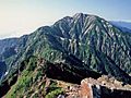
 | spiritual Mount Tateyama". InsideJapan Tours. Retrieved April 22, 2022. "地理院地図|国土地理院". Fay, Tom; Lang, Wes (2019-03-27). Hiking and Trekking in the Japan... 9 KB (576 words) - 20:11, 26 March 2024 |
"The Urasenke Konnichian Web Site". "【ご報告】苗字がかわりました : Chori official blog-地図をつくる-". Archived from the original on 2015-02-05. Retrieved 2015-02-05. "千... 6 KB (421 words) - 19:11, 16 December 2023 |
 | 『日本鉄道旅行地図帳 12 九州』 p.51 Shinchosha JR九州新幹線、鹿児島線、指宿枕崎線、鹿児島中央駅(九州の駅ゆったり紀行) Archived 2013-02-18 at archive.today(in Japanese) - Nishinihon Shinbun 『日本鉄道旅行地図帳... 8 KB (474 words) - 22:45, 16 February 2023 |
 | 4)(以降1901年頃まで、同じ書名で年度ごとの講義録を刊行) 『内外地理学講義』、谷島屋書店(1899.1) 『新万国地図 5版』、丸善(1900.8) 『地理學講義 11版』、文武堂(1901.11) 『中学地理. 日本之部』、冨山房(1903.4) 『地理教科書 本邦篇 訂2版』、冨山房(1904.1)→ 新訂(1911)... 12 KB (1,667 words) - 06:05, 16 March 2024 |
 | Dori (市電通り, lit. "Tramway Street"). Imao, Keisuke, ed. (2008). 日本鉄道旅行地図帳 4号関東2 日本鉄道旅行地図帳 - 全線・全駅・全廃線 [Japan Railway Travel Atlas - All Lines, Stations... 2 KB (153 words) - 06:26, 2 December 2021 |
 | 山岳標高一覧-1003山-』における改定値。なお、旧版での標高は1,980m。 日本山岳会『新日本山岳誌』ナカニシヤ出版、2005年 国土地理院 基準点成果等閲覧サービス 田代博、藤本一美、清水長正、高田将志 『山の地図と地形』 山と渓谷社、1996年 梅沢俊、瀬尾央 『新版・空撮登山ガイド1 北海道の山々』... 5 KB (534 words) - 23:41, 20 October 2023 |
 | Daijiten (in Japanese). Tokyo: Shogakukan. 2012. Retrieved 2012-05-22. 日本全国お雑煮文化圏地図 [O-zōni cultural zones map throughout Japan] (in Japanese). TripAdvisor... 5 KB (585 words) - 06:15, 23 January 2022 |
First Japan Map Picture Book ~ 47 Prefectures to Sing and Remember (はじめての日本地図絵本 歌って覚える47都道府県, Hajimete no Nihonchizu Ehon Utatte Oboeru 47 Todōfuken).... 11 KB (812 words) - 14:18, 7 March 2024 |
 | Shinsho. ISBN 978-4334032715. (In Japanese) Shigeo, Nakajima (2003). 大名の日本地図. Bunshun Shinsho. ISBN 978-4166603527. (In Japanese) Mass, Jeffrey P. and... 13 KB (983 words) - 07:26, 3 March 2024 |
35-45 WOMAN (in Japanese). Retrieved 2021-04-04. ザテレビジョン. "妻夫木聡や新しい地図、上白石萌音、ルフィら総勢11人が宝くじブランドの新CMに集結! (1/3) | 芸能ニュースならザテレビジョン". ザテレビジョン (in Japanese)... 53 KB (3,876 words) - 01:26, 14 May 2024 |
 | ISBN 978-4-7959-1955-6. 宮本幸枝 (2005). 津々浦々「お化け」生息マップ - 雪女は東京出身? 九州の河童はちょいワル? -. 大人が楽しむ地図帳. 村上健司監修. 技術評論社. p. 80. ISBN 978-4-7741-2451-3. "賢淵". tabidoki.jrnets.co.jp... 12 KB (1,717 words) - 22:36, 26 February 2024 |
 | single is a double A-side single "Installation/Sono Koe ga Chizu ni Naru" (その声が地図になる, lit. "The Voice Will Become A Map") was released on February 3, 2015.... 127 KB (6,145 words) - 10:37, 11 May 2024 |
fields and have fun together. 243 "I Will Draw a Map" (Japanese: オラの作った宝の地図だゾ) August 22, 1997 (1997-08-22) "A repayment of the Kasukabe Defense Force"... 392 KB (175 words) - 22:47, 2 May 2024 |
Research Institute (日本地図研究所, Nihon chizu kenkyūjo), an internal division of Heibonsha, was spun off as the Heibonsha Map Publishing (平凡社地図出版, Heibonsha chizu... 10 KB (1,042 words) - 19:24, 24 September 2023 |
 | Kagoshima Branch]. JRTE website. Retrieved 18 May 2018. Imao, Keisuke (2009). 日本鉄道旅行地図帳 12号 九州 沖縄―全線・全駅・全廃線 [Japan Rail Travel Atlas No. 12 Kyushu Okinawa - all... 5 KB (363 words) - 12:02, 29 February 2024 |
 | "日本の主な山岳標高(富山県)". Geospatial Information Authority of Japan. Retrieved 2011-09-01. "地図閲覧サービス(五龍岳)". 国土地理院. Retrieved 2011-09-01. 深田久弥 (1982). 日本百名山... 2 KB (120 words) - 11:05, 10 February 2023 |
 | the private sector, such as those depicted in the "Koutou Shinchizu" (高等新地図) published in 1953. At a House of Councilors General Affairs Committee meeting... 15 KB (1,753 words) - 19:30, 10 February 2024 |
| historical linguistics at the National Institute for Japanese Language and Linguistics 『日本言語地図』地図画像 (Linguistic Atlas of Japan) Portals: Japan Languages... 34 KB (3,661 words) - 08:47, 20 April 2024 |