 | りも不可然義候間、天下之さわり可成候條、其分別無之者ハ可被加御成敗候事、 伴天連門徒心ざし次第ニ下々成候義ハ、八宗九宗之儀候間不苦事、 大唐、南蛮、高麗江日本仁を売遣侯事曲事、付、日本ニおゐて人の売買停止の事。 牛馬ヲ売買、ころし食事、是又可為曲事事。 右條々堅被停止畢、若違犯之族有之は忽可被処厳科者也、... 9 KB (1,586 words) - 22:59, 15 October 2023 |
 | Hannō SI27 Higashi-Hannō 東飯能 44.5 | | ■ Hachiko Line SI28 Koma 高麗 48.5 | | Hidaka SI29 Musashi-Yokote 武蔵横手 51.3 | | SI30 Higashi-Agano 東吾野... 32 KB (1,401 words) - 10:10, 28 April 2024 |
 | of the west face of the Ninomaru. The remaining gate is in the Kōrai-mon (高麗門 "Goryeo Gate") style. It is registered as an Important Cultural Property... 79 KB (10,405 words) - 16:14, 16 February 2024 |
Station 国際展示場駅(こくさいてんじじょう) Kōma Station (Iwate) 好摩駅(こうま) Koma Station (Saitama) 高麗駅(こま) Komaba-Tōdaimae Station 駒場東大前駅(こまばとうだいまえ) Komachi Station 古町駅(こまち) Komachiya... 130 KB (6 words) - 13:11, 16 March 2024 |
House of Kim (김 / 金); Also called "Later Goguryeo" (후고구려 / 後高句麗) Goryeo (고려 / 高麗) (AD 918–1392) – Ruled by the House of Wang (왕 / 王) Later Sabeol (후사벌 / 後沙伐)... 556 KB (58,098 words) - 14:40, 5 April 2024 |
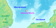 | 바라보는 것이 가능하다.(有鬱陵島 在縣正東海中 新羅時稱于山國 一云武陵 一云羽陵 ... 一云于山武陵本二島 相距不遠 風日淸明 則可望見(「高麗史」 권58 地理3, 東界 蔚珍縣條)" "Annals of King Sejong, Geographical Treatise, Gangwon... 149 KB (18,154 words) - 21:54, 3 April 2024 |
Stele) Memorial Stele to the Enemy and Allied War Dead During the Imjin War 高麗陣敵味方戦死者供養碑 Kōrai-jin teki mikata senshi-sha kuyō-hi Kōya 34°13′05″N 135°36′13″E... 57 KB (344 words) - 15:46, 20 June 2022 |
78195949°E / 35.00071875; 135.78195949 (Kōdaiji Gardens) 8 1661 Koma-dera ruins 高麗寺跡 Komadera ato Kizugawa Asuka period temple ruins 34°44′58″N 135°49′40″E... 61 KB (373 words) - 06:41, 8 October 2023 |
 | scriptures, Song edition] (in Japanese). Daigo-ji. Retrieved 2017-11-14. "- 埼玉県ときがわ町 - 国指定文化財" [Saitama Prefecture, Tokigawa - National Cultural Properties] (in... 132 KB (5,257 words) - 09:39, 22 April 2024 |
Okada (岡田郡) Districts, Ibaraki (Merged into Yūki District) Koma District (高麗郡), Saitama (Merged into Iruma District) Niikura District (新座郡), Saitama (Merged... 95 KB (9,869 words) - 17:36, 9 February 2024 |