The Myanmar census 2014 (Burmese: ၂၀၁၄ ခုနှစ် လူဦးရေနှင့် အိမ်အကြောင်းအရာ သန်းခေါင်စာရင်း) was a nationwide census between 30 March and 10 April 2014 in... 17 KB (1,765 words) - 17:40, 31 October 2023 |
The Burmese census is an official count of the human population in Burma (Myanmar). The earliest census on record in Burmese history was taken in 1359... 4 KB (354 words) - 17:13, 12 November 2023 |
defined groupings, such as the Burmese Chinese and Panthay, Burmese Indians, Anglo-Burmese, and Gurkhas. The 2014 Myanmar Census enumerated 51,486,253 persons... 21 KB (1,745 words) - 06:18, 30 March 2024 |
"Myanmar's tiny Jewish community is rattled after military coup". Times of Israel. "Census data shows Myanmar Muslim population has fallen". "Myanmar,... 29 KB (2,742 words) - 12:58, 20 April 2024 |
 | Chin State (redirect from Chin State, Burma) Incubator "Union of Myanmar". City Population. Retrieved 10 April 2009. Census Report. The 2014 Myanmar Population and Housing Census. Vol. 2. Naypyitaw:... 18 KB (1,265 words) - 17:07, 3 April 2024 |
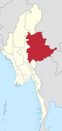
 | Kayah State (redirect from Kayah State, Burma) Kayah State (Burmese: ကယားပြည်နယ်, pronounced [kəjá pjìnɛ̀]), or Karenni State, is a state of Myanmar. Situated in eastern Myanmar, it is bounded on the... 30 KB (2,786 words) - 17:52, 22 April 2024 |
schooling is 15 to 16 years old. The literacy rate of Myanmar, according to the 2014 Myanmar Census stands at 89.5% (males: 92.6%, females: 86.9%). The... 19 KB (2,015 words) - 02:42, 26 February 2024 |
 | the Tibeto-Burman-speaking Pyu city-states in Upper Myanmar and the Mon kingdoms in Lower Myanmar. In the 9th century, the Bamar people entered the upper... 233 KB (22,024 words) - 19:33, 17 April 2024 |
 | Rakhine State (redirect from Rakhine State, Myanmar) pronunciation: [jəkʰàiɰ̃ pjìnɛ̀]), formerly known as Arakan State, is a state in Myanmar (Burma). Situated on the western coast, it is bordered by Chin State to the... 52 KB (4,778 words) - 20:42, 30 March 2024 |
 | Kayin State (redirect from Karan State, Burma) of Labour, Immigration and Population MYANMAR (July 2016). The 2014 Myanmar Population and Housing Census Census Report Volume 2-C. Department of Population... 26 KB (2,196 words) - 23:38, 6 April 2024 |
 | Thailand's largest migrant population. According to the 2014 Myanmar Census, 1,418,472 former Burmese residents, including 812,798 men and 605,674 women, were... 7 KB (594 words) - 19:39, 1 November 2023 |
 | Myawaddy (redirect from Myawaddy, Myanmar) trading point between Myanmar and Thailand. Myawaddy is 170 kilometres (110 mi) east of Mawlamyine, the fourth largest city of Myanmar, and 426 kilometres... 14 KB (1,186 words) - 10:14, 24 April 2024 |
 | Naypyidaw Union Territory (category Districts of Myanmar) Territory, comprising 1.5% of Myanmar's total thilashin community. Census Report. The 2014 Myanmar Population and Housing Census. Vol. 2. Naypyitaw: Ministry... 10 KB (582 words) - 18:34, 18 March 2024 |
 | Mon State (redirect from Mon State, Myanmar) Kyaikkami. The majority of people are Buddhist. According to the 2014 Myanmar Census, Buddhists make up 92.6% of Mon State’s population, forming the largest... 23 KB (1,993 words) - 04:24, 14 December 2023 |
Burmese in Malaysia mostly comprise manual labourers and refugees. The 2014 Myanmar Census enumerated 303,996 Burmese individuals living in Malaysia.... 4 KB (301 words) - 14:35, 17 November 2023 |
 | This is a demography of Myanmar (also known as Burma) including statistics such as population, ethnicity, language, education level, and religious affiliations... 41 KB (1,622 words) - 21:26, 23 March 2024 |
 | Fourth-largest religion in Myanmar, being practised by 1.7% of the population of Myanmar. Hinduism is practised by about 890,000 people in Myanmar, and has been influenced... 17 KB (1,690 words) - 07:09, 25 April 2024 |
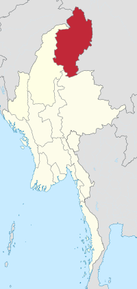 | Kachin State (redirect from Kachin State, Burma) Kachin State (Burmese: ကချင်ပြည်နယ်; Kachin: Jinghpaw Mungdaw) is the northernmost state of Myanmar. It is bordered by China to the north and east (Tibet... 31 KB (2,987 words) - 00:16, 12 April 2024 |
 | Bago Region (redirect from Pegu Division, Burma) Region (Burmese: ပဲခူးတိုင်းဒေသကြီး, pronounced [bəɡó táɪɰ̃ dèθa̰ dʑí]; formerly Pegu Division and Bago Division) is an administrative region of Myanmar, located... 20 KB (1,647 words) - 14:27, 18 February 2024 |
 | Yangon Region (redirect from Rangoon Division, Burma) Division and Yangon Division) is an administrative region of Myanmar. Located in central Myanmar, the region is bordered by Bago Region to the north and east... 23 KB (1,688 words) - 16:49, 11 April 2024 |
citizens of Burmese ancestry. The 2014 Myanmar Census enumerated 17,975 Burmese individuals living in India. The Burmese refugee population in India is overwhelmingly... 5 KB (545 words) - 15:02, 1 March 2024 |
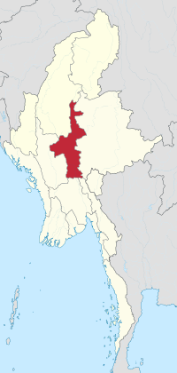
 | Sagaing Region (redirect from Sagaing Division, Burma) Region (Burmese: စစ်ကိုင်းတိုင်းဒေသကြီး, pronounced [zəɡáɪ̯ɰ̃ táɪ̯ɰ̃ dèθa̰ dʑí]; formerly Sagaing Division) is an administrative region of Myanmar, located... 23 KB (1,739 words) - 16:41, 11 April 2024 |
Upper Myanmar (Burmese: အထက်မြန်မာပြည် or မြန်မာပြည်အထက်ပိုင်း, also called Upper Burma) is one of two geographic regions in Myanmar, the other being Lower... 17 KB (1,561 words) - 22:42, 19 April 2024 |
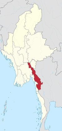
 | Tanintharyi Region (redirect from Tenasserim Division, Burma) cross-border checkpoint into Thailand has been developed since 2014. According to the 2014 Myanmar Census, Buddhists make up 87.5% of Tanintharyi Region's population... 24 KB (1,906 words) - 16:27, 23 April 2024 |
 | Magway Region (redirect from Magwe Division, Burma) of Burma had a large Anglo-Burmese population, descended from Western oil workers and their Burmese partners. According to the 2014 Myanmar Census, Buddhists... 23 KB (1,746 words) - 17:29, 31 December 2022 |
 | and the capital of the Bago Region in Myanmar. It is located 91 kilometres (57 mi) north-east of Yangon. The Burmese name Bago (ပဲခူး) is likely derived... 27 KB (2,618 words) - 07:10, 16 February 2024 |
 | Ayeyarwady Region (redirect from Irrawaddy Division, Burma) minorities of Christians, Muslims, Hindu and Baháʼís. According to the 2014 Myanmar Census, Buddhists make up 92.2% of Ayeyawady Region's population, forming... 22 KB (1,712 words) - 08:57, 23 March 2024 |
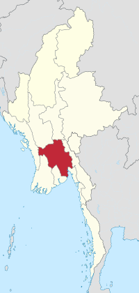
 | Mandalay Region (redirect from Mandalay Division, Burma) reunified all of central Myanmar. Central Myanmar was under Ava's control until 1527, and under the Shans of Monhyin (1527–1555). Burmese literature and culture... 24 KB (1,773 words) - 04:25, 8 January 2024 |
 | Taunggyi Myanmar portal "UNFPA Myanmar - Census". Myanmar.unfpa.org. Retrieved 5 February 2019. Wikimedia Commons has media related to Cities in Myanmar. "World... 37 KB (87 words) - 17:32, 26 January 2024 |
 | Shan State (redirect from Shan State, Burma) 2002–2003. Myanmar portal "Union of Myanmar". City Population. Retrieved 25 December 2008. Census Report. The 2014 Myanmar Population and Housing Census. Vol... 52 KB (4,923 words) - 05:15, 29 March 2024 |