 | Aerial photograph interpretation is a method of extrapolating geological details of the ground surface from aerial images. It allows geologists to analyze... 15 KB (1,668 words) - 15:33, 12 April 2024 |
 | military aerial reconnaissance, using photographs taken from reconnaissance aircraft and reconnaissance satellites. The principles of image interpretation have... 25 KB (3,070 words) - 15:31, 12 April 2024 |
 | Seabed 2030 Aerial photograph interpretation (geology) Harrell, James A.; Brown, V. Max (1992). "The world's oldest surviving geological map—the 1150... 12 KB (1,560 words) - 21:30, 16 November 2023 |
 | 3390/rs6109600. hdl:11311/886093. Ho, H. (2004). Application of aerial photograph interpretation in geotechnical practice in Hong Kong (MSc thesis). University... 58 KB (6,685 words) - 15:33, 12 April 2024 |
 | review of geologic literature, geologic maps, geotechnical reports, engineering plans, environmental reports, stereoscopic aerial photographs, remote sensing... 13 KB (1,561 words) - 17:42, 14 March 2024 |
 | Photogrammetry (redirect from Aerial photogrammetry) lesser distance than traditional aerial (or orbital) photogrammetry. Photogrammetric analysis may be applied to one photograph, or may use high-speed photography... 30 KB (3,121 words) - 20:08, 6 April 2024 |
 | Satellite imagery (redirect from Satellite photograph) the Soviet satellite Luna 3, on a mission to photograph the far side of the Moon. The Blue Marble photograph was taken from space in 1972, and has become... 25 KB (2,722 words) - 10:18, 1 May 2024 |
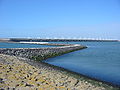
 | California Coastal Records Project (category Aerial photography) Club for their work on the project. The photographs were exhibited in 2003 at the Center for Land Use Interpretation, in a nearly ten-hour-long simulation... 7 KB (649 words) - 22:35, 29 January 2024 |
 | Mount Kilimanjaro (redirect from Geology of Mount Kilimanjaro) February 2011 at the Wayback Machine Mount Kilimanjaro live webcam Kilimanjaro flora picture gallery Aerial photographs of Mount Kilimanjaro, 1937–38... 90 KB (9,111 words) - 18:31, 7 May 2024 |
 | ecology and geography as part of his early work applying aerial photographs interpretation to studies of interactions between environment and vegetation... 6 KB (583 words) - 18:18, 1 January 2024 |
 | 2014 Oso landslide (section Geological context) "Fresh landslide tailings depicted in 2006 aerial photograph, with topology map comparisons". Historic Aerials. Nationwide Environmental Title Research... 61 KB (5,122 words) - 07:26, 18 April 2024 |
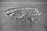 | Mount Takahe (section Geology) Quaternary Glacial Erosion and Corrie Formation, Marie Byrd Land, Antarctica". Geology. 1 (2): 76. Bibcode:1973Geo.....1...75A. doi:10.1130/0091-7613(1973)1<75:ROQGEA>2... 53 KB (5,485 words) - 10:45, 16 April 2024 |
 | Coastal management (section Aerial photographs) maps. Aerial photographs are the most commonly used data source because many coastal areas have extensive aerial photo coverage.Aerial photographs generally... 55 KB (6,689 words) - 09:20, 10 March 2024 |
Aerial reconnaissance using heavier-than-air machines was an entirely new science that had to be improvised step-by-step. Early operations were low-level... 17 KB (2,521 words) - 16:12, 16 November 2022 |
 | James W. Bagley (category Aerial photographers) James Warren Bagley (October 31, 1881 – February 19, 1947) was an American aerial photographer, topographic engineer and inventor. Bagley was born in Fayetteville... 24 KB (3,451 words) - 00:57, 14 March 2024 |
 | Rephotography (redirect from Re-photograph) communication to understand social change. Three main approaches are common - photographs of places, participants, or activities, functions, or processes – with... 14 KB (1,689 words) - 09:21, 11 December 2023 |
 | compiled, initially from topographic maps and stereographic interpretation of aerial photographs and then from satellite photography and radar data. Since... 20 KB (2,043 words) - 19:20, 2 May 2024 |
 | usually required, while photo-interpretation may better for land cover classes that can be reliably identified on aerial photographs or high resolution satellite... 62 KB (7,676 words) - 12:12, 25 April 2024 |
 | Digital outcrop model (category Geologic maps) mesh. DOMs allow for interpretation and reproducible measurement of different geological features, e.g. orientation of geological surfaces, width and thickness... 16 KB (1,888 words) - 14:30, 9 March 2024 |
 | analyzed by geographical information systems (GIS), photo interpretation of aerial photographs, and Web mining. Geoinformatics combines geospatial analysis... 9 KB (893 words) - 21:42, 20 March 2024 |
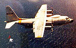 | disoriented state. When it recovered, it attacked the crew. By 1958, the Fulton aerial retrieval system, or "Skyhook", was finished. The ground system could be... 16 KB (1,962 words) - 18:16, 17 April 2024 |
 | a crime scene and physical evidence in its true form is key for the interpretation of the investigation. Knowing that crucial information for an investigation... 21 KB (2,793 words) - 16:06, 29 April 2024 |
 | the use of water level profiles, field research and the interpretation of aerial photographs, was of the opinion that on the surface not two, but three... 12 KB (1,718 words) - 12:52, 25 December 2022 |
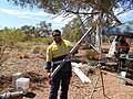
Geobotanical prospecting (category Economic geology) discover the ore deposits. Aerial photography is simply taking photographs of the ground from a higher elevation. Using aerial photography it is possible... 43 KB (4,484 words) - 03:43, 10 May 2024 |
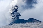 | Volcano (redirect from Volcano (geological landform)) incandescent and, by 1785, the works of Decartes and others were synthesised into geology by James Hutton in his writings about igneous intrusions of magma. Lazzaro... 88 KB (9,880 words) - 08:45, 6 May 2024 |
 | Geography of Easter Island (section Geology) Bibcode:1937GSAB...48.1589B. doi:10.1130/GSAB-48-1589. Rapanui: Edmunds and Bryan Photograph Collection Archived 3 April 2008 at the Wayback Machine. Libweb.hawaii... 34 KB (3,779 words) - 17:17, 28 February 2024 |
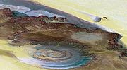
 | n'Ajjer National Park. The plateau is of great geological and aesthetic interest. Its panorama of geological formations of rock forests, composed of eroded... 32 KB (3,806 words) - 21:23, 30 November 2023 |
 | mapping of large or complex sites. Aerial photographs are used to document the status of the archaeological dig. Aerial imaging can also detect many things... 133 KB (13,777 words) - 18:17, 9 May 2024 |
 | Bolshoy Lyakhovsky Island (section Geology) Islands. aerial photographs of New Siberian Islands. Internet Archive Wayback Machine. anonymous, ndb, Bol'shoy Lyahkovskiy. aerial photograph of Bolshoy... 25 KB (2,815 words) - 06:11, 19 October 2023 |
 | Pleistocene climate interpretation based on marine terrace chronology, Mahia Peninsula, North Island, New Zealand". New Zealand Journal of Geology and Geophysics... 46 KB (4,941 words) - 14:20, 10 March 2024 |