 | of the formation of the Agulhas Basin. The Agulhas Ridge extends from the northern tip of the Meteor Rise towards the Agulhas Bank south of South Africa... 10 KB (1,182 words) - 02:24, 4 December 2023 |
 | Madagascar (35 Sv). The net transport of the Agulhas Current is estimated as 100 Sv. The flow of the Agulhas Current is directed by the topography. The... 20 KB (2,322 words) - 00:15, 20 April 2024 |
 | between the Agulhas Bank (south of South Africa) and the Agulhas passage (south of the bank), typical for a continent-ocean transition. The Agulhas Passage... 17 KB (1,775 words) - 19:34, 13 January 2024 |
 | Current. The Agulhas Current follows the continental shelf of the African east-coast, pass through the Agulhas Passage until it leaves the Agulhas Bank and... 6 KB (637 words) - 07:26, 26 October 2021 |
 | The Agulhas Bank (/əˈɡʌləs/, from Portuguese for Cape Agulhas, Cabo das Agulhas, "Cape of Needles") is a broad, shallow part of the southern African continental... 64 KB (7,112 words) - 08:40, 12 April 2024 |
 | one south of the equator moving anticlockwise (including the Agulhas Current and Agulhas Return Current), constitute the dominant flow pattern. During... 115 KB (12,666 words) - 18:58, 21 April 2024 |
| The Agulhas Passage is an abyssal channel located south of South Africa between the Agulhas Bank and Agulhas Plateau. About 50 km (31 mi) wide, it connects... 6 KB (722 words) - 22:11, 16 April 2024 |
 | Atlantic Ocean (redirect from Atlantic basin) into the Indian Ocean. The 20° East meridian, running south from Cape Agulhas to Antarctica defines its border. In the 1953 definition it extends south... 113 KB (12,337 words) - 23:35, 23 April 2024 |
 | continental shelves. These fracture zones, and their extensions into the Agulhas Basin, are flow-lines describing the motion of Africa and Antarctica since... 30 KB (3,428 words) - 09:28, 4 November 2023 |
 | the Agulhas Basin and then east through the Agulhas Passage and over the southern margins of the Agulhas Plateau and then into the Mozambique Basin. Climate... 22 KB (2,608 words) - 02:23, 16 April 2024 |
 | List of submarine topographical features (redirect from List of Oceanic basins) and mass extinction in the ocean basins. Campbell Plateau (South Pacific) Challenger Plateau (South Pacific) Agulhas Plateau (Southwest Indian) Caribbean–Colombian... 50 KB (3,893 words) - 05:30, 25 January 2024 |
 | Northernmost Point — Cape Chelyuskin, Russia Southernmost Point — Cape Agulhas, South Africa Westernmost Point — Pointe des Almadies, Senegal Easternmost... 10 KB (1,128 words) - 12:23, 26 April 2024 |
Trenchia agulhasae argentinae (Clarke, 1961) This species was found in the Agulhas Basin. MolluscaBase eds. (2020). MolluscaBase. Trenchia agulhasae (Clarke... 2 KB (127 words) - 17:18, 17 July 2021 |
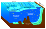
The process occurs during the retroflection of the Agulhas Current via shedding of anticyclonic Agulhas Rings, cyclonic eddies and direct inflow. The leakage... 17 KB (1,727 words) - 21:23, 2 January 2024 |
 | Indian Ocean Agulhas Current – Western boundary current of the southwest Indian Ocean that flows down the east coast of Africa Agulhas Return Current –... 29 KB (3,837 words) - 08:09, 29 April 2024 |
 | Hyphessobrycon agulha (also known as the red-tailed flag tetra) is a species of tetra in the family Characidae. As a freshwater fish, it inhabits the basin of the... 3 KB (284 words) - 18:22, 12 April 2024 |
 | Karoo Supergroup (redirect from Karoo Basin) Jurassic. These accumulated in a retroarc foreland basin called the "main Karoo" Basin. This basin was formed by the subduction and orogenesis along the... 34 KB (3,509 words) - 10:28, 15 November 2023 |
 | which are influenced by the warm Agulhas Current. The Cape of Good Hope is the boundary between the Benguela and Agulhas provinces. Amsterdam and St. Paul... 3 KB (274 words) - 07:29, 4 March 2022 |
 | "rhinoceros field"). Fynbos vegetation types, code FF: Agulhas Limestone Fynbos (FFl 1) Agulhas Sand Fynbos (FFd 7) Albertinia Sand Fynbos (FFd 9) Algoa... 25 KB (2,721 words) - 19:26, 15 January 2024 |
 | 1867) (In Agulhas current and off west coast in Agulhas water pockets) Short-headed lantern fish, Diaphus brachycephalus Tåning, 1928 (In Agulhas current... 250 KB (24,072 words) - 12:22, 25 February 2024 |
 | seaway across the southern and eastern parts of the country, called the Agulhas Sea. The sea floor consisted of the Klipheuwel Group in the west, the Natal... 42 KB (4,512 words) - 05:25, 25 November 2023 |
 | Siberian traps are underlain by the Tungus Syneclise, a large sedimentary basin containing thick sequences of Early-Mid Paleozoic aged carbonate and evaporite... 22 KB (2,618 words) - 09:22, 13 February 2024 |
 | Falkland Plateau separated from the Agulhas Bank, opening the South Atlantic which, however, remained an enclosed basin north of the Falkland Plateau until... 11 KB (1,280 words) - 14:20, 7 November 2023 |
Ring shedding (section Agulhas current) without any rings occur. The Agulhas rings transport warm and salty water to the Southern Atlantic Ocean. The water from the Agulhas rings can be up to 5 °C... 12 KB (1,498 words) - 17:54, 5 January 2024 |
 | inshore Agulhas marine ecoregion which extends from Cape Point to the Mbashe river over the continental shelf, in the overlap zone between Cape Agulhas and... 104 KB (17,470 words) - 14:01, 3 April 2024 |
 | Geography of Africa (section Inland basins) Ras ben Sakka in Tunisia, at 37°21′ N, to the most southerly point, Cape Agulhas in South Africa, 34°51′15″ S, is a distance approximately of 8,000 km (5... 37 KB (4,497 words) - 01:34, 31 March 2024 |
 | ridge was confirmed by sonar in 1925 and was found to extend around Cape Agulhas into the Indian Ocean by the German Meteor expedition. In the 1950s, mapping... 12 KB (1,412 words) - 11:01, 24 March 2024 |
 | Water (AABW) enters the Cape Basin between the Agulhas Bank and the Agulhas Ridge after which it flows west north of the Agulhas Ridge. AABW then retroflects... 14 KB (1,566 words) - 01:29, 15 August 2023 |
 | the Black Needles peak (Pico das Agulhas Negras). The higher part of the park contains the origins of 12 river basins that supply the Rio Grande (Grand... 4 KB (441 words) - 01:22, 10 November 2022 |
 | to the International Hydrographic Organization, officially meet at Cape Agulhas, the most southern point of Africa. Its territory includes Marion and Prince... 50 KB (5,890 words) - 20:42, 6 March 2024 |