 | The Alazeya (Russian: Алазея; Yakut: Алаһыай, romanized: Alahıay) is a river in the northeastern part of Yakutia, Russia which flows into the Arctic between... 4 KB (351 words) - 04:18, 19 April 2024 |
 | certain distance, rises the Alazeya Plateau. Rivers Bolshaya Ercha, a tributary of the Indigirka, and Arga-Yuryakh, of the Alazeya basin, have their sources... 4 KB (374 words) - 11:29, 2 May 2024 |
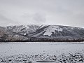
The Alazeya Plateau (Russian: Алазейское плоскогорье) is a mountain plateau in the Sakha Republic, Far Eastern Federal District, Russia. The area is named... 3 KB (223 words) - 08:10, 7 July 2023 |
 | Druzhina Uyandina Khatyngnakh Khachimcher Buor-Yuryakh Allaikha Byoryolyokh Alazeya Buor-Yuryakh Rossokha Arga-Yuryakh Kolyma (near Ambarchik) Anyuy (near... 30 KB (1,933 words) - 04:05, 20 January 2024 |
 | sailed down the Indigirka and east to the Alazeya where he met Zyryan. Zyryan and Dezhnyov stayed at the Alazeya, while Stadukhin went east, reaching the... 15 KB (1,598 words) - 04:51, 1 April 2024 |
 | Indigirka River (1,726 km) Selennyakh River (796 km) Indigirka River tributary Alazeya River (1,590 km) Anabar River (939 km) Yana River (872 km) Adycha River... 64 KB (5,029 words) - 20:31, 29 April 2024 |
 | Siberian elk A. a. buturlini Ranges from northeastern Siberia from the Alazeya River basin east to the Kolyma and Anadyr basins and south through the... 134 KB (14,392 words) - 22:23, 23 April 2024 |
 | places of Sakha (Yakutia), Russia, mainly in the East Siberian Lowland: Alazeya Plateau Anabar Plateau Kigilyakh Peninsula, with Mount Kigilyakh and Cape... 7 KB (574 words) - 10:04, 5 December 2023 |
 | Missouri United States 84. Tobol 1,591 989 Irtysh Kazakhstan, Russia 85. Alazeya 1,590 988 64,700 East Siberian Sea Russia 86. Jubba–Shebelle 1,580* 982*... 54 KB (2,042 words) - 17:56, 3 April 2024 |
 | isolated hills rising from the tundra, such as the Kisilyakh-Tas by the Alazeya. Most of the kigilyakhs of Yakutia are found in these elevated areas of... 8 KB (859 words) - 13:12, 21 February 2024 |
 | Kyun-Tas Polousny Range Kondakov Plateau Suor Uyata Ulakhan-Sis Range Alazeya Plateau Yukaghir Highlands Nera Plateau Kolyma Mountains Omsukchan Range... 7 KB (595 words) - 00:14, 23 January 2024 |
River (雅砻江) China 1,571 976 39 Han River (Han Jiang) China 1,532 952 40 Alazeya (Алазея) Russia 1,520 944 41 Godavari River (Dakshina Ganga) India 1,465... 16 KB (459 words) - 05:49, 22 December 2023 |
 | North Siberian Lowland South Siberian Mountains West Siberian Lowland Alazeya Anabar Angara Indigirka Irtysh Kolyma Lake Baikal Lena Nizhnyaya Tunguska... 84 KB (8,028 words) - 07:18, 4 May 2024 |
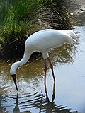 | the east a much larger population in Yakutia between the Yana and the Alazeya rivers. Like most cranes, the Siberian crane inhabits shallow marshlands... 27 KB (2,957 words) - 19:55, 4 April 2024 |
Buor-Yuryakh, a right tributary of the Alazeya Buor-Yuryakh (Alazeya Plateau), a left tributary of the Alazeya Buor-Yuryakh (Chondon), a tributary of... 503 bytes (98 words) - 10:26, 5 December 2023 |
 | 000 km2. Among the rivers flowing into the East Siberian Sea, the Indigirka, Alazeya, Chukochya, Kolyma, Rauchua, Chaun, and Pegtymel are the most important... 22 KB (2,756 words) - 22:23, 17 December 2023 |
 | Buor-Yuryakh (category Tributaries of the Alazeya) Republic (Yakutia), Russia. It is the second largest tributary of the Alazeya. The river has a length of 244 kilometres (152 mi) and a drainage basin... 4 KB (314 words) - 21:24, 16 January 2023 |
 | plain in the northeastern parts of Sakha Republic in the basin of the Alazeya, Bolshaya Chukoch'ya and lower reaches of the Kolyma rivers. The lowland... 2 KB (196 words) - 10:18, 26 May 2023 |
be about 32,000 years old, while the other, recovered in 2015 near the Alazeya River, was dated at approximately 30,000-40,000 years old. These nematodes... 69 KB (7,330 words) - 00:35, 26 April 2024 |
Alazeya Plateau to the south by the roughly 50 km (31 mi) wide plain of the Shangina. The Shangina river begins in the northern part of the Alazeya Plateau... 3 KB (299 words) - 21:44, 16 January 2023 |
 | the Siberian sucker (C. c. rostratus), is found in the Yana, Indigirka, Alazeya and Kolyma river basins. It is a bottom-feeding fish, eating aquatic plants... 9 KB (901 words) - 15:00, 19 February 2024 |
Russia (Omoloy basin) Arga-Yuryakh (Rassokha), a river in Yakutia, Russia (Alazeya basin) Arga, an alternative name for Akçadağ, Turkey This disambiguation... 527 bytes (105 words) - 03:37, 17 May 2022 |
Location Country Russia Physical characteristics Source • location Alazeya Plateau Mouth Kolyma • coordinates 67°05′38″N 153°01′40″E / 67.0938°N... 1 KB (77 words) - 15:34, 28 March 2024 |
 | Taui and Uda rivers, respectively. 1641 – Dmitri Zyrian discovers the Alazeya, which he ascends as far as the tree line. 1642–43 – Dutch explorer Abel... 108 KB (10,891 words) - 10:29, 19 April 2024 |
 | formed when the Prikolyma and Omolon terranes collided with the Alazeya island arc (or Alazeya-Oloy volcanic arc). When the Kolyma-Omolon microcontinent collided... 46 KB (5,045 words) - 02:31, 8 April 2024 |
the Suor Uyata range. It rises above the tundra on the right bank of the Alazeya, roughly 160 kilometres (99 mi) south of the river's mouth in the shores... 4 KB (346 words) - 10:06, 5 December 2023 |
 | Omuk-Kyuyol (category Alazeya basin) large area of lakes between the basin of the Indigirka to the west and the Alazeya to the east. The main outflowing river is the Omuk-Kyuyol-Seen (Омук-Кюёль-Сээн)... 2 KB (158 words) - 02:12, 7 November 2023 |
Lowland, part of the Yana-Indigirka Lowland, lies to the north and the Alazeya Plateau to the east. The highest point of the Moma Range is an unnamed... 3 KB (253 words) - 20:38, 22 July 2020 |
(25 mi) to the ESE of the eastern end of the range, on the right bank of the Alazeya River, rises the 327 metres (1,073 ft) high Kisilyakh-Tas, another important... 5 KB (432 words) - 10:06, 5 December 2023 |
 | metres (29 ft). The settlement was located just east of the mouth of the Alazeya River in an area of tundra, swamps, and lakes. Valkumey – Another Siberian... 2 KB (140 words) - 18:43, 28 June 2022 |