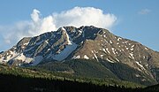
 | Archuleta County is a county located in the U.S. state of Colorado. As of the 2020 census, the population was 13,359. The county seat and the only incorporated... 14 KB (886 words) - 17:10, 23 April 2024 |
 | of Colorado listed on the National Register of Historic Places. They are distributed over 63 of Colorado's 64 counties; only the City and County of Broomfield... 67 KB (727 words) - 23:50, 27 April 2024 |
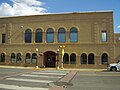
 | municipality that is the county seat, the most populous community, and the only incorporated municipality in Archuleta County, Colorado, United States. The... 21 KB (1,379 words) - 17:57, 28 April 2024 |
 | and a census-designated place (CDP) located in and governed by Archuleta County, Colorado, United States. The Arboles post office has the ZIP code 81121... 9 KB (224 words) - 19:48, 18 October 2023 |
 | 7,785 ft (2,373 m) elevation mountain pass in Archuleta County, Colorado in the United States. Colorado mountain passes "Yellowjacket Pass". Geographic... 1,022 bytes (45 words) - 23:47, 2 August 2021 |
 | Pagosa hot springs (category Hot springs of Colorado) gosah) is a hot spring system located in the San Juan Basin of Archuleta County, Colorado. The town of Pagosa Springs claim they are the world's deepest... 12 KB (1,223 words) - 01:20, 27 April 2024 |
 | Chromo is an unincorporated community and U.S. Post Office in Archuleta County, Colorado, United States. The Chromo Post Office has the ZIP Code 81128... 7 KB (289 words) - 20:43, 8 April 2024 |
Felipe Archuleta (1910–1991), American folk artist Katherine Archuleta (born c. 1949), American political executive Archuleta County, Colorado. Archuleta, New... 4 KB (207 words) - 07:20, 20 May 2023 |
 | Cumbres and Toltec Scenic Railroad (redirect from Windy Point, Conejos County) Historic Places listings in Colorado § Archuleta County National Register of Historic Places listings in Conejos County, Colorado National Register of Historic... 41 KB (4,544 words) - 19:43, 14 March 2024 |
 | Navajo Lake (category Buildings and structures in Archuleta County, Colorado) Juan County and Rio Arriba County in northwestern New Mexico, in the southwestern United States. Portions of the reservoir extend into Archuleta County in... 5 KB (342 words) - 14:38, 9 September 2023 |
Antonio Don Archuleta (1855 – c. March 1918) was a member of the Colorado Senate and the namesake of Archuleta County; he was influential in its formation... 5 KB (532 words) - 22:33, 19 December 2023 |
 | Tierra Amarilla Land Grant (category Archuleta County, Colorado) occupying a large portion of Rio Arriba County, New Mexico and a small portion of Archuleta County Colorado. The land begins at the Rio Nutrias in the... 18 KB (2,195 words) - 03:53, 28 April 2024 |
 | Chimney Rock National Monument (redirect from Chimney Rock, Colorado) National Forest in southwestern Colorado which includes an archaeological site. This area is located in Archuleta County, Colorado, between Durango and Pagosa... 13 KB (1,488 words) - 21:43, 20 February 2024 |
 | to March 2, 1883. Pagosa Springs has been the seat of Archuleta County, Colorado since the county was created on April 14, 1885. Parachute was originally... 214 KB (5,473 words) - 17:31, 18 February 2024 |
Juanita is a ghost town in Archuleta County in southwest Colorado. Accessed from County Road 551 and located at 37°1.634′N 107°9.036′W / 37.027233°N... 538 bytes (60 words) - 21:42, 25 January 2024 |
 | San Juan National Forest (category Protected areas of Archuleta County, Colorado) acres (2,935.7 sq mi, or 7,603.42 km²) in western Colorado. The forest occupies land in Archuleta, Conejos, Dolores, Hinsdale, La Plata, Mineral, Montezuma... 5 KB (379 words) - 16:48, 26 September 2023 |
Altura is a populated place in Archuleta County, Colorado, United States. Altura is located at 37°11′00″N 107°11′28″W / 37.18333°N 107.19111°W / 37... 5 KB (56 words) - 18:31, 14 January 2018 |
| Alamosa County, Colorado. The Town of Pagosa Springs is the seat of Archuleta County, Colorado. The City of Salida is the seat of Chaffee County, Colorado. The... 117 KB (1,665 words) - 22:20, 17 October 2023 |
 | private lands to its confluence with the San Juan River in Archuleta County, Colorado. Colorado classifies the Rio Blanco as an Aquatic Life Coldwater Class... 5 KB (492 words) - 15:58, 25 November 2023 |
| Washington County, Colorado. The Town of Pagosa Springs is the seat of Archuleta County, Colorado. The Town of Del Norte is the seat of Rio Grande County, Colorado... 56 KB (2,229 words) - 07:55, 17 October 2023 |
 | Southern Ute Indian Reservation (redirect from Southern Ute Indian Tribe of the Southern Ute Reservation, Colorado) counties; in descending order of surface area they are La Plata, Archuleta, and Montezuma Counties. The reservation has a land area of 1,058.785 sq mi (2,742... 15 KB (1,249 words) - 04:50, 28 March 2024 |
Archuleta County School District 50-JT is a school district headquartered in Pagosa Springs, Colorado. The district includes most of Archuleta County... 4 KB (313 words) - 21:43, 21 July 2023 |
Pass (Archuleta County, Colorado), a mountain pass in Archuleta County, Colorado, United States. Yellowjacket Pass (Rio Blanco County, Colorado), a mountain... 696 bytes (104 words) - 23:57, 2 August 2021 |
 | Navajo River (category Rivers of Archuleta County, Colorado) before heading northwest to a confluence with the San Juan in Archuleta County, Colorado. A large portion of its water is diverted across the Continental... 3 KB (190 words) - 19:55, 10 May 2020 |
 | junction with Colorado State Highway 12 was designated a National Scenic Byway. The designation, which includes State Highway 12 and the county roads over... 12 KB (480 words) - 07:48, 27 December 2023 |
| This list ranks the 64 counties of the U.S. State of Colorado by population as of July 1, 2023, as estimated by the United States Census Bureau. This list... 29 KB (372 words) - 22:41, 20 March 2024 |
 | south Sandoval County - south San Juan County - west Archuleta County, Colorado - north Conejos County, Colorado - north Carson National Forest (part)... 23 KB (1,775 words) - 14:49, 26 April 2024 |
 | Rio Chama (category Rivers of Archuleta County, Colorado) just within Archuleta County, Colorado. From there the Rio Chama flows generally south. After a few miles the river enters Rio Arriba County, New Mexico... 12 KB (1,283 words) - 21:24, 23 February 2024 |
 | which Archuleta County, Baca County, Crowley County, Custer County, Delta County, Douglas County, El Paso County, Fremont County, Grand County, Jackson... 55 KB (270 words) - 05:11, 7 January 2024 |
East Fork Rio Chama (category Rivers of Archuleta County, Colorado) confluence with the West Fork Rio Chama in Archuleta County, Colorado that forms the Rio Chama. List of rivers of Colorado "East Fork Rio Chama". Geographic Names... 1 KB (77 words) - 08:17, 10 May 2020 |