
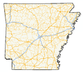
Highway 262 (AR 262, Ark. 262, and Hwy. 262) is an east–west state highways in Woodruff County, Arkansas. The route is maintained by the Arkansas Department...
7 KB (642 words) - 16:37, 16 February 2024
of state highways in the U.S. state of Arkansas. The state does not use a numbering convention. Generally, the two-digit odd numbered highways run north–south...
244 KB (1,754 words) - 02:30, 7 April 2024
following highways are numbered 262: BR-262 Manitoba Provincial Road 262 Prince Edward Island Route 262 Japan National Route 262 Arkansas Highway 262 California...
2 KB (146 words) - 23:24, 4 April 2024

Highway 33 (AR 33, Ark. 33, and Hwy. 33) is a north–south state highway in eastern Arkansas. The highway runs 23.86 miles (38.40 km) from Highway 130...
17 KB (1,144 words) - 01:44, 4 October 2023
in Craighead County, Arkansas, United States. The population was 262 at the 2010 census. It is included in the Jonesboro, Arkansas Metropolitan Statistical...
9 KB (779 words) - 23:35, 22 April 2024

Map." Arkansas State Highway and Transportation Department. Retrieved on September 28, 2011. "1936 Pulaski County, Arkansas Highway Map." Arkansas State...
14 KB (990 words) - 19:59, 30 April 2024

Highway 130 (AR 130, Ark. 130, and Hwy. 130) is an east–west state highway in Arkansas County, Arkansas. Mostly a low-volume, two-lane road, Highway 130...
20 KB (1,999 words) - 08:26, 24 January 2024
unincorporated community in Columbia County, Arkansas, United States, at an elevation of 262 feet (80 m). Highway 98 passes south through Atlanta before turning...
2 KB (57 words) - 01:31, 25 December 2023

Interstate 49 (I-49) is an Interstate Highway in the state of Arkansas. There are two main sections of the highway across different sides of the state....
42 KB (2,963 words) - 20:04, 25 April 2024

Highway 263 (AR 263, Ark. 263, and Hwy. 263) is a north–south state highway in the Arkansas Ozark Mountains. A low-volume, two-lane road, Highway 263...
15 KB (1,340 words) - 16:33, 16 February 2024

miles (37 km) to Magnolia and west 30 miles (48 km) to Texarkana. Arkansas Highway 29 passes through the center of Lewisville, leading north 23 miles...
14 KB (760 words) - 13:55, 13 May 2024

Highway 49 U.S. Highway 64 Highway 17 Highway 33 Highway 37 Highway 38 Highway 78 Highway 145 Highway 260 Highway 262 Highway 269 Highway 284 Highway...
31 KB (2,569 words) - 01:20, 26 April 2024

Route 67 (US 67) is a U.S. highway running from Presidio, Texas northeast to Sabula, Iowa. In the U.S. state of Arkansas, the route runs 279.15 miles...
31 KB (1,405 words) - 23:16, 16 May 2024

Highway 261 (AR 261, Ark. 261, and Hwy. 261) is a designation for two state highways in Arkansas. Both are short rural highways in the Arkansas Delta...
9 KB (786 words) - 16:36, 16 February 2024

Route 62 (US 62) is a U.S. highway running from El Paso, Texas northeast to Niagara Falls, New York. In the U.S. state of Arkansas, the route runs 329.9 miles...
32 KB (1,224 words) - 21:38, 16 March 2024
access to two concurrent United States highways: U.S. Highway 62 (US 62) and US 412, and thirteen Arkansas state highways. Baxter County is served by two public...
61 KB (5,534 words) - 02:12, 6 May 2024

Route 64 is a U.S. highway running from Teec Nos Pos, Arizona east to Nags Head, North Carolina. In the U.S. state of Arkansas, the route runs 246.35...
36 KB (2,100 words) - 21:08, 16 March 2024

to the west of downtown Lowell, with access to the city at Exit 78 (Arkansas Highway 264). I-49 leads north 14 miles (23 km) to its end north of Bentonville...
14 KB (1,211 words) - 16:33, 21 April 2024

U.S. Highway 49 U.S. Highway 49 Business U.S. Highway 49Y U.S. Highway 63 U.S. Highway 412 U.S. Highway 412 Business Highway 1 Highway 34 Highway 69 Highway...
19 KB (1,530 words) - 13:47, 22 April 2024
[page needed] Planning and Research Division (2010). "Arkansas Road Log Database". Arkansas State Highway and Transportation Department. Archived from the...
33 KB (1,402 words) - 15:08, 27 July 2023

County, Arkansas, United States. The population was 96 at the 2020 census. Black Springs is located in southwestern Montgomery County. Arkansas Highway 8 passes...
10 KB (826 words) - 23:09, 11 May 2024
Arkansas. As of the 2020 census, the population was 23,090. The county seat is Forrest City. St. Francis County comprises the Forrest City, Arkansas Micropolitan...
19 KB (1,512 words) - 14:19, 22 April 2024

to Lewisville, the county seat, and east 3 miles (5 km) to Buckner. Arkansas Highway 53 has its northern terminus at US 82 and leads south through the center...
11 KB (944 words) - 14:10, 13 May 2024
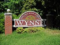
Highway System in the 1920s and 30s, U.S. Route 64 was built west from Memphis, through Wynne, and to points west. Also, the north–south Arkansas Highway...
20 KB (1,694 words) - 00:59, 25 April 2024

WAH-shi-tah) is a county located in the south central part of the U.S. state of Arkansas. As of the 2020 census, the population was 22,650. The county seat is Camden...
16 KB (1,248 words) - 17:03, 25 April 2024
Arizona State Route 66* Arkansas Highway 66 California State Route 66* County Route 66 (California)* Colorado State Highway 66 Connecticut Route 66 Florida...
7 KB (534 words) - 23:07, 4 April 2024
(Maryland) New England Route 1 (former) State highway systems Alabama State Route 1 Alaska Route 1 Arkansas Highway 1 California State Route 1; merges in some...
20 KB (1,261 words) - 10:34, 3 May 2024

Franklin County is a county in Arkansas. As of the 2020 census, the population was 17,097. The county has two county seats, Charleston and Ozark. The county...
19 KB (1,379 words) - 13:46, 22 April 2024
1.4 square miles (3.7 km2), all land. US 63 U.S. Route 63 Business Arkansas Highway 230 As of the 2020 United States census, there were 2,409 people, 950...
11 KB (816 words) - 18:15, 23 April 2024

U.S. Route 65 in Missouri (redirect from Missouri State Highway 3 (decommissioned))
north–south U.S. highway that runs from Clayton, Louisiana to Albert Lea, Minnesota. In Missouri, the highway enters the state from Arkansas, just south of...
20 KB (782 words) - 14:52, 6 May 2024