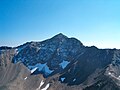
The Aroser Rothorn is the highest mountain of the Plessur Alps. It is located between Arosa and Lenzerheide in the canton of Graubünden and with a summit...
2 KB (101 words) - 03:27, 30 April 2022
Alps Aroser Rothorn (2980 m) highest peak of the Plessur Range Parpaner Rothorn (2861 m) east of Lenzerheide in the Plessur Range Furna Rothorn (2362...
2 KB (311 words) - 10:21, 28 December 2023

of Graubünden. It has an elevation of 2,906 metres and is, after the Aroser Rothorn, the second highest peak of the Plessur Alps. Retrieved from the Swisstopo...
1 KB (76 words) - 16:40, 14 May 2022

lies in the middle of the range. Peaks of the Plessur Alps are the Aroser Rothorn (highest, 2,985 m (9,793 ft)) and Stätzer Horn (2,576 m (8,451 ft))...
3 KB (196 words) - 15:39, 10 January 2022

located south of Arosa in Graubünden. It is part of the range east of the Aroser Rothorn. On the north side of the mountain lies the Älplisee. Swisstopo maps...
1 KB (51 words) - 01:09, 2 May 2022
Country Highest mountain Height (m) Image 63 Plessur Alps Switzerland Aroser Rothorn 2,980 64 Oberhalbstein Alps Switzerland Italy Piz Platta 3,392 65 Albula...
21 KB (929 words) - 22:40, 23 April 2024

The Aroser Weisshorn is a mountain of the Plessur Alps, overlooking Arosa in the canton of Graubünden. A two-stage cable car links the top of the mountain...
2 KB (70 words) - 03:29, 30 April 2022

The Parpaner Rothorn is a mountain of the Plessur Alps, overlooking Parpan in the canton of Graubünden. The summit is easily accessible with a cable car...
1 KB (57 words) - 23:08, 16 May 2022

range. Other prominent mountains are Piz Russein, Piz Kesch, Calanda, Aroser Rothorn and Rheinwaldhorn, see list of mountains of Graubünden for a more exhaustive...
60 KB (6,436 words) - 23:23, 8 April 2024

town of Arosa is at the top of the Schanfigg valley at the foot of the Aroser Weisshorn (2,653 m (8,704 ft)). Adjoining are the areas of Innerarosa, Dorf-Obersee...
20 KB (1,818 words) - 20:55, 29 March 2024
regions in Germany2 63 Plessur Alps Western Limestone Alps Switzerland Aroser Rothorn 2,980 64 Oberhalbstein Alps Western Limestone Alps Switzerland Italy...
34 KB (556 words) - 14:50, 2 February 2024
Ob-Fontana Marla Sur-Funtauna Merla Unter-Fontana Merla Suot-Funtauna Merla Aroser Rothorn Piz Cotschen Averserrhein or Averser Bach Rain d'Avras Aversertal Val...
16 KB (1,116 words) - 23:46, 4 April 2024

summits are on cantonal borders, 2 of which being tripoints (Brienzer Rothorn and Säntis). A number of mountains (e.g. Titlis, Chasseral, Lägern) straddle...
76 KB (1,275 words) - 20:55, 5 May 2024

Elevation 2,843 m (9,327 ft) Prominence 497 m (1,631 ft) Parent peak Aroser Rothorn Isolation 11.5 km (7.1 mi) Listing Alpine mountains 2500-2999 m Coordinates...
2 KB (94 words) - 10:12, 2 February 2024

Elevation 2,764 m (9,068 ft) Prominence 209 m (686 ft) Parent peak Aroser Rothorn Coordinates 46°44′23.2″N 9°42′06.7″E / 46.739778°N 9.701861°E / 46...
1 KB (34 words) - 22:42, 1 May 2022
07°19′26″E / 47.01472°N 7.32389°E / 47.01472; 7.32389 Chutzen Bern 42 Aroser Rothorn 2980 13.5 1349 46°44′16″N 09°36′50″E / 46.73778°N 9.61389°E / 46...
9 KB (124 words) - 14:44, 1 May 2024

Ticino 1606 140.14 Piz Terri 3149 Po Stausee Isel Graubünden 1606 8.49 Aroser Rothorn 2980 Rhine Lago d'Isola Graubünden 1604 36.33 Zapporthorn 3152 Po Hinterstockensee...
26 KB (248 words) - 17:58, 23 April 2024

Elevation 2,781 m (9,124 ft) Prominence 345 m (1,132 ft) Parent peak Aroser Rothorn Listing Alpine mountains 2500-2999 m Coordinates 46°46′51.7″N 9°44′05...
1 KB (41 words) - 18:05, 16 April 2022

Piz Lischana 3.105 Sesvenna Range Piz Umbrail 3.033 Sesvenna Range Aroser Rothorn 2.980 Plessur Range Schesaplana 2.964 Rätikon Lenzerhorn 2.906 Plessur...
8 KB (391 words) - 17:32, 10 January 2022

Elevation 2,534 m (8,314 ft) Prominence 417 m (1,368 ft) Parent peak Aroser Rothorn Listing Alpine mountains 2500-2999 m Coordinates 46°52′27.1″N 9°37′58...
1 KB (74 words) - 17:27, 16 April 2022
Elevation 2,441 m (8,009 ft) Prominence 144 m (472 ft) Parent peak Aroser Rothorn Coordinates 46°47′49.9″N 9°34′57.6″E / 46.797194°N 9.582667°E / 46...
1 KB (44 words) - 17:31, 16 May 2022

Elevation 2,683 m (8,802 ft) Prominence 137 m (449 ft) Parent peak Aroser Rothorn Coordinates 46°46′28.3″N 9°35′47.4″E / 46.774528°N 9.596500°E / 46...
1 KB (45 words) - 17:42, 16 April 2022

Elevation 2,636.4 m (8,650 ft) Prominence 55 m (180 ft) Parent peak Aroser Rothorn Coordinates 46°48′32.4″N 9°46′48.72″E / 46.809000°N 9.7802000°E /...
1 KB (50 words) - 01:07, 6 May 2022
Elevation 2,781 m (9,124 ft) Prominence 290 m (950 ft) Parent peak Aroser Rothorn Coordinates 46°45′49.8″N 9°43′44.5″E / 46.763833°N 9.729028°E / 46...
1 KB (47 words) - 06:02, 29 September 2022

Elevation 2,658 m (8,720 ft) Prominence 249 m (817 ft) Parent peak Aroser Rothorn Coordinates 46°48′26.4″N 9°46′33.9″E / 46.807333°N 9.776083°E / 46...
1 KB (47 words) - 17:19, 16 April 2022
Elevation 2,810 m (9,220 ft) Prominence 237 m (778 ft) Parent peak Aroser Rothorn Coordinates 46°43′32″N 9°39′37″E / 46.72556°N 9.66028°E / 46.72556;...
1 KB (45 words) - 17:26, 16 April 2022
Highest point Elevation 2,297 m (7,536 ft) Prominence 19 m (62 ft) Parent peak Aroser Rothorn Coordinates 46°51′26.5″N 9°50′45″E / 46.857361°N 9.84583°E / 46.857361;...
2 KB (114 words) - 16:14, 27 September 2023

09°13′31″E / 46.48111°N 9.22528°E / 46.48111; 9.22528 Lepontine Alps Moesa Aroser Rothorn 2980 1349 46°44′16″N 09°36′50″E / 46.73778°N 9.61389°E / 46.73778;...
27 KB (336 words) - 16:08, 5 May 2024
S-Tyrol/Trentino IT 1874 554 Aroser Rothorn 2980 1349 46°44′16″N 09°36′50″E / 46.73778°N 9.61389°E / 46.73778; 9.61389 (554. Aroser Rothorn (2980 m)) Plessur...
94 KB (827 words) - 18:53, 6 July 2023

From west to east, north of Mera and Inn Oberhalbstein Piz Platta Plessur Aroser Weisshorn Albula Piz Kesch, Piz Lunghin Rätikon Schesaplana Silvretta Piz...
36 KB (3,643 words) - 14:41, 29 April 2024