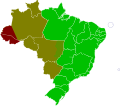
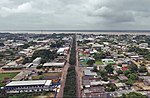
 | Atalaia do Norte is the most western municipality in the Brazilian state of Amazonas. As of 2020, its population was 20,398 and its area is 76,355 km2... 4 KB (163 words) - 08:16, 14 April 2024 |
since 1851 has formed the border with Peru. It includes much of the Atalaia do Norte municipality as well as adjacent territories in the western section... 10 KB (817 words) - 02:53, 13 March 2024 |
Map and Location". www.citypopulation.de. Retrieved 2024-01-10. "Atalaia do Norte (Municipality, Brazil) - Population Statistics, Charts, Map and Location"... 24 KB (1,176 words) - 12:31, 16 February 2024 |
 | going to pass by the riverside community of São Rafael on their way to Atalaia do Norte, in the remote Javari Valley, in the far western part of the state... 17 KB (1,597 words) - 19:27, 13 February 2024 |
 | traveling along the Itaguaí River, heading towards the municipality of Atalaia do Norte. Bruno Pereira was born in the city of Recife, in Pernambuco, on 15... 28 KB (2,260 words) - 08:11, 29 April 2024 |
 | river of the upper Amazon Basin. It forms the eastern boundary of Atalaia do Norte municipality in the Amazonas state of north-western Brazil. Its main... 1 KB (63 words) - 13:42, 17 February 2023 |
 | Nova Olinda do Norte is a municipality located in the Brazilian state of Amazonas. Its population was 38,026 (2020) and its area is 5,609 km2. The town... 2 KB (76 words) - 19:47, 16 April 2024 |
 | a river of the upper Amazon Basin. It traverses some 370 km of the Atalaia do Norte municipality in the Amazonas state of north-western Brazil. It drains... 5 KB (193 words) - 07:11, 13 August 2023 |
 | Westernmost town: Atalaia do Norte Easternmost town: Nhamundá Northernmost town: Curaçá Southernmost town: Mucuri Westernmost town: Formosa do Rio Preto Easternmost... 8 KB (831 words) - 01:54, 24 January 2024 |
a tributary of the Solimões near the village of Atalaia do Norte. List of rivers of Amazonas Vale do Javari Brazilian Ministry of Transport 04°31′52″S... 953 bytes (59 words) - 13:42, 17 February 2023 |
 | Manaus (redirect from Lugar de Barra do Rio Negro) Ciência e Tecnologia do Amazonas; Centro Universitário do Norte—UNINORTE; Lutheran University of Brazil—Universidade Luterana do Brasil; Centro de Educação... 88 KB (8,167 words) - 00:45, 26 March 2024 |
 | time notation in Brazil Lists of time zones The municipalities of Atalaia do Norte, Eirunepé, Envira, Guajará and Ipixuna are located entirely west of... 13 KB (1,289 words) - 00:23, 2 May 2024 |
 | are further grouped into four mesoregions. Mesoregions Centro Amazonense Norte Amazonense Sudoeste Amazonense Sul Amazonense Geography of Brazil List of... 3 KB (58 words) - 14:35, 1 March 2024 |
 | Amazonas (Brazilian state) (redirect from Estado do Amazonas) Seringal) Tiradentes Museum Manaus Manauara Mall Center Amazonas Mall Center ViaNorte Mall Ponta Negra Mall Millennium Mall Samauma Park and Mall Center Cidade... 62 KB (6,545 words) - 10:39, 18 April 2024 |
reported the repercussion of the case on the Internet: "Memes sobre caso do 'menino do Acre' chamam atenção nas redes". O Globo. April 6, 2017. Archived from... 399 KB (13,455 words) - 21:07, 5 May 2024 |
 | was transformed into a parish, with the name of the parish of Nossa Senhora do Carmo of Tupinambarana. Was still a simple parish when started a revolution... 14 KB (971 words) - 17:47, 17 December 2023 |
 | Retrieved 2020-05-07. SOUZA, Marcio. História da Amazônia: Do período pré-colombiano aos desafios do século XXI [History of the Amazon: From the pre-Columbian... 11 KB (1,106 words) - 04:33, 9 December 2023 |
 | ISA: Instituto Socioambiental, retrieved 2016-08-30 "Normais Climatológicas Do Brasil 1981–2010" (in Portuguese). Instituto Nacional de Meteorologia. Retrieved... 11 KB (673 words) - 11:37, 6 April 2024 |
in northwestern Brazil. It is entirely within the municipality of Atalaia do Norte. Curuçá is a tributary of the Javary River. On August 13, 1930, the... 5 KB (311 words) - 00:23, 25 July 2023 |
2010 – Todos os Estados do Brasil" (PDF). Archived from the original (PDF) on 21 August 2013. Retrieved 29 July 2013. Atlas do Desenvolvimento Humano no... 19 KB (304 words) - 00:32, 11 April 2024 |
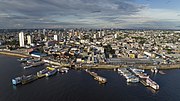
 | of cargo transportation in Amazonas. Its Catedral Prelatícia Nossa Senhora do Rosário, dedicated to Our Lady of the Rosary, is the episcopal see of the... 11 KB (634 words) - 07:58, 13 October 2023 |
List of beaches in Portugal (section Norte) Praia do Areal (Lourinhã e Atalaia, Lourinhã) Praia do Baleal-Campismo (Peniche) Praia do Baleal-Norte (Peniche) Praia do Baleal-Sul (Peniche) Praia do Caniçal... 36 KB (3,589 words) - 01:06, 23 April 2024 |
 | located on the northern shore of the Rio Negro River, in the region of Cabeça do Cachorro, Amazonas state, Brazil. The city was founded in 1668 as an aldea... 10 KB (462 words) - 07:11, 11 January 2024 |
 | ISA: Instituto Socioambiental, retrieved 2016-08-30 "Normais Climatológicas Do Brasil 1981–2010" (in Portuguese). Instituto Nacional de Meteorologia. Retrieved... 8 KB (241 words) - 22:11, 14 December 2023 |
uncontacted or recently contacted indigenous people in the country and on the Vale do Javari. Pereira was born as the second of the three sons to Max Pereira Pereira... 10 KB (812 words) - 21:58, 31 January 2024 |
 | (in Portuguese). Ministério do Meio Ambiente. SOUZA, Marcio. História da Amazônia: Do período pré-colombiano aos desafios do século XXI [History of the... 7 KB (688 words) - 13:57, 1 March 2024 |
 | Boca do Acre (Mouth of Acre) is a municipality located in the Brazilian state of Amazonas. Its population was 34,635 (2020) and its area is 22,349 km2... 3 KB (110 words) - 00:26, 15 April 2024 |
 | 35°49′19″W / 9.60278°S 35.82194°W / -9.60278; -35.82194 Santa Luzia do Norte is a municipality located in the Brazilian state of Alagoas. Its population... 4 KB (60 words) - 01:22, 16 April 2024 |
Paraíso do Norte is a municipality in the state of Paraná in the Southern Region of Brazil. List of municipalities in Paraná IBGE 2020 "Divisão Territorial... 5 KB (159 words) - 19:35, 13 May 2022 |
 | Alto Solimoes Amaturá Atalaia do Norte Benjamin Constant Fonte Boa Jutaí Santo Antônio do Içá São Paulo de Olivença Tabatinga Tonantins Jurua Carauari... 2 KB (53 words) - 01:35, 16 April 2024 |