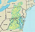
 | (secondary coordinates) The Atlantic Seaboard Fall Line, or Fall Zone, is a 900-mile (1,400 km) escarpment where the Piedmont and Atlantic coastal plain meet in... 13 KB (972 words) - 16:26, 13 March 2024 |
coordinates) The Atlantic Seaboard Fall Line, or Fall Zone, is a 1,400-kilometre (900-mile) escarpment where the Piedmont and Atlantic Coastal Plain meet... 9 KB (959 words) - 14:01, 20 April 2024 |
 | U.S. Route 1 (redirect from Atlantic Highway (United States)) assigned to the existing Atlantic Highway, which followed the Atlantic Seaboard Fall Line between the Piedmont and the Atlantic Plain north of Augusta,... 56 KB (5,386 words) - 03:55, 25 April 2024 |
 | East Coast of the United States (redirect from Atlantic Seaboard) Seaboard, the Atlantic Coast, and the Atlantic Seaboard, is the region encompassing the coastline where the Eastern United States meets the Atlantic Ocean... 33 KB (2,230 words) - 23:43, 30 April 2024 |
 | larger rivers cross the Atlantic seaboard fall line. Over time, many large cities emerged where these rivers cross the fall line as watermills allowed for... 9 KB (865 words) - 05:37, 29 January 2023 |
 | the Piedmont Upland, and the Piedmont Lowlands sections. The Atlantic Seaboard Fall Line marks the Piedmont's eastern boundary with the Coastal Plain... 8 KB (793 words) - 03:20, 29 March 2024 |
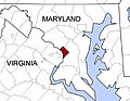
 | an area of rapids located where the Potomac River crosses the Atlantic Seaboard fall line where Washington, DC; Maryland; and Virginia meet. Descending... 3 KB (278 words) - 02:45, 3 September 2023 |
 | 1, 1967, when it merged with the Atlantic Coast Line Railroad, its longtime rival, to form the Seaboard Coast Line Railroad. Predecessor railroads dated... 62 KB (7,506 words) - 20:02, 17 March 2024 |
(Jefferson Davis Highway) across the Appomattox River at the Atlantic Seaboard fall line. It joins Colonial Heights and Petersburg, Virginia. Originally... 4 KB (147 words) - 10:49, 21 February 2023 |
 | purposes. Located near where the Rappahannock River crosses the Atlantic Seaboard fall line, Fredericksburg was a prominent port in Virginia during the colonial... 77 KB (6,208 words) - 12:35, 18 April 2024 |
 | Plateau, and the Atlantic coastal plain. Once the Potomac drops from the Piedmont to the Coastal Plain at the Atlantic Seaboard fall line at Little Falls... 89 KB (6,049 words) - 06:48, 13 March 2024 |
 | South Carolina (section Atlantic Coastal Plain) rice plantations in the South Carolina Lowcountry, east of the Atlantic Seaboard fall line. Plantation labor was done by African slaves who formed the majority... 126 KB (11,852 words) - 06:01, 1 May 2024 |
 | Klint South Småland-Sub-Cambrian escarpment Malta Victoria Lines Atlantic Seaboard Fall Line Florida Escarpment, Gulf of Mexico Sigsbee Escarpment, Gulf of... 10 KB (907 words) - 16:07, 13 December 2023 |
 | and West Texas in this subregion) by physiography: Atlantic coastal plain Atlantic Seaboard Fall Line East Coast of the United States Great Basin Great... 34 KB (3,022 words) - 15:12, 26 April 2024 |
refer to: Atlantic Seaboard Fall Line, a long escarpment in the Eastern United States Fall Line Freeway, Georgia State Route 540 Fall Line Trail, a multi-use... 794 bytes (140 words) - 16:15, 16 April 2024 |
 | hydrological divide in eastern North America that separates the easterly Atlantic Seaboard watershed from the westerly Gulf of Mexico watershed. The divide nearly... 34 KB (1,383 words) - 03:42, 25 April 2024 |
 | kaolin deposits are found in central Georgia, on a stretch of the Atlantic Seaboard fall line between Augusta and Macon. This area of thirteen counties is... 50 KB (5,470 words) - 21:16, 11 April 2024 |
 | Potomac River to the north, the Fall Line to the west, the Virginia-North Carolina border to the south, and the Atlantic Ocean to the east. Generally peaceful... 75 KB (5,500 words) - 13:12, 5 April 2024 |
 | The coastal plain transitions to the Piedmont region along the Atlantic Seaboard fall line, the elevation at which waterfalls first appear on streams and... 214 KB (19,249 words) - 23:39, 30 April 2024 |
 | Philadelphia (category Port cities and towns of the Pennsylvania Atlantic coast) N, 75.20747 W. Philadelphia is located on the Atlantic Seaboard Fall Line that separates the Atlantic Plain from the Piedmont. The Schuylkill River's... 277 KB (23,179 words) - 13:25, 27 April 2024 |
 | Washington, D.C. (category Mid-Atlantic states) Potomac River, located at the northwest edge of the city at the Atlantic Seaboard fall line. The highest natural elevation in the district is 409 feet (125 m)... 290 KB (24,196 words) - 06:34, 1 May 2024 |
 | Delaware (category Mid-Atlantic states) The Atlantic Seaboard fall line approximately follows the Robert Kirkwood Highway between Newark and Wilmington; south of this road is the Atlantic Coastal... 144 KB (13,123 words) - 23:57, 29 April 2024 |
 | Street (now Florida Avenue) at the base of the escarpment of the Atlantic Seaboard Fall Line, to the southeast by the Anacostia River, to the southwest by... 33 KB (3,956 words) - 13:46, 8 April 2024 |
Gently-Hargrove, she launched The Fall Line on June 12, 2017. The podcast's name refers to the Atlantic Seaboard fall line in Georgia. The first season of... 4 KB (344 words) - 03:04, 14 March 2024 |
 | River, the Eastern Branch, the base of the escarpment of the Atlantic Seaboard Fall Line, and Rock Creek. His plan specified locations for two buildings... 80 KB (7,994 words) - 03:46, 1 May 2024 |
 | southwest 30 mi (48 km) to Macon. Milledgeville is located on the Atlantic Seaboard fall line of the United States. The Oconee River flows a half mile east... 35 KB (2,626 words) - 19:03, 15 April 2024 |
 | River, the Eastern Branch, the base of the escarpment of the Atlantic Seaboard Fall Line, and Rock Creek (named on the plan as Pine Creek). His plan specified... 68 KB (7,335 words) - 22:43, 28 April 2024 |
on the fall line of the Potomac River, the point furthest inland reachable by ships coming up the river. (See also Atlantic Seaboard fall line.) Below... 2 KB (254 words) - 02:25, 18 December 2020 |
 | Augusta. Its location was unique due to its close proximity to the Atlantic seaboard fall line. Between 1790 and 1854, Wilkes County's area was reduced as it... 19 KB (1,487 words) - 20:48, 23 April 2024 |
 | the Atlantic Seaboard Fall Line which separates the Piedmont region from the Atlantic coastal plain. Historically, U.S. Route 1 followed this line, and... 31 KB (3,443 words) - 00:44, 1 May 2024 |