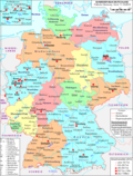
 | Bad Lauterberg is a town in the district of Göttingen, in Lower Saxony, Germany. It is situated in the southern Harz, approx. 15 km southwest of Braunlage... 3 KB (237 words) - 11:19, 20 January 2024 |
 | line from Ilsenburg to Bad Lauterberg, which roughly separates the catchment areas for the Weser (Upper Harz) and Elbe (Lower Harz). Only on the southeastern... 62 KB (8,357 words) - 09:53, 14 May 2024 |
 | western Harz mountain range, extending from Herzberg and Bad Lauterberg at the southern edge to Bad Harzburg and Ilsenburg on the northern slopes. 95% of... 18 KB (2,393 words) - 11:38, 5 December 2023 |
 | Langensalza (Thuringia) Bad Lauchstädt (Saxony-Anhalt) Bad Lausick (Saxony) Bad Lauterberg im Harz (Lower Saxony) Bad Liebenstein (Thuringia) Bad Liebenwerda (Brandenburg)... 79 KB (356 words) - 19:10, 17 February 2024 |
Osterode am Harz as collateral. In 1415, Eric declared war on the Counts of Hohenstein, because both sides claimed the county of Bad Lauterberg im Harz and defeated... 6 KB (461 words) - 01:03, 13 May 2024 |
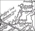 | Oder Valley Railway (category Transport in the Harz) Scharzfeld, through Bad Lauterberg, to St. Andreasberg-Silberhütte. It traced the upper course of the River Oder in the West Harz mountains and was commonly... 6 KB (721 words) - 21:17, 11 September 2023 |
via Herzberg am Harz, Bad Lauterberg-Barbis, Bad Sachsa, Walkenried and Ellrich. The line is 69 kilometres (43 mi) long. The South Harz line runs roughly... 13 KB (1,183 words) - 10:26, 5 December 2022 |
Mine Pit, Göttingerode Friederike Iron Ore Mine Pit Wolkenhügel Pit, Bad Lauterberg (closed 2007) August Gallery Aufcontainingtigkeit Pit, 1741 - 1761,... 7 KB (754 words) - 00:39, 6 August 2022 |
 | Herzberg (Harz) station is a railway station in the municipality of Herzberg am Harz, located in the Göttingen district in Lower Saxony, Germany. Eisenbahnatlas... 3 KB (71 words) - 22:54, 10 December 2023 |
 | Accessed on 2 Nov 2010. Topographische Karte 1:25,000, No. 4328 Bad Lauterberg im Harz 51°41′31″N 10°21′31″E / 51.69194°N 10.35861°E / 51.69194; 10... 3 KB (404 words) - 18:47, 30 August 2021 |
 | der Helmetalbahn" (in German). Retrieved 2008-08-04. "Stadtplan Bad Lauterberg im Harz - Osterhagen". Retrieved 2008-08-04. - town plan of Osterhagen,... 2 KB (183 words) - 20:55, 4 January 2022 |
 | Eichelnkopf (category Hills of the Harz) ISBN 3-510-65154-5, p. 19 Topographische Karte 1:25000 Nr. 4328 Bad Lauterberg im Harz Geologische Karte Harz 1:100000, Herausgegeben vom Landesamt für Geologie und... 2 KB (214 words) - 18:54, 7 June 2017 |
 | Krumme Lutter (category Tributaries of the Oder (Harz)) Lutter. List of rivers of Lower Saxony Grube Wolkenhügel bei karstwanderweg.de Topographical map, 1:25,000 series, no. 4328, Bad Lauterberg im Harz. v t e... 2 KB (93 words) - 13:15, 25 February 2020 |
Aschentalshalbe (category Mountains of the Harz) nearby Schadenbeeksköpfe. Topographic map 1:25,000 series, No. 4328, Bad Lauterberg im Harz Map services of the Federal Agency for Nature Conservation Aschentalshalbe... 4 KB (447 words) - 16:39, 27 March 2020 |
Adlersberg (redirect from Adlersberg (Harz)) Pagelsburg 1.2 km south, the Höxterberg 1.6 km southwest and the Großer Knollen 1.9 km southeast. Topographic map 1:25000, No. 4328 Bad Lauterberg im Harz... 2 KB (104 words) - 10:58, 21 February 2018 |
Koboltstaler Köpfe (category Mountains of the Harz) Gödeckental. To the southwest it falls away steeply towards the Großes Gödeckental valley. Topographische Karte 1:25000, No. 4328 Bad Lauterberg im Harz v t e... 2 KB (143 words) - 14:20, 3 January 2024 |
Steile Wand (category Hills of the Harz) south side with deciduous woods. There is an old quarry on its steep northwest slope. Topographic map 1:25,000 No. 4328, Bad Lauterberg im Harz v t e... 2 KB (119 words) - 03:22, 18 April 2019 |
| Grade Lutter (category Tributaries of the Oder (Harz)) Kupferhütte of Bad Lauterberg to form the Lutter. List of rivers of Lower Saxony Topographische Karte 1:25000, Nr. 4328 Bad Lauterberg im Harz v t e v t e... 2 KB (83 words) - 10:30, 19 February 2020 |
 | Sperrlutter (category Tributaries of the Oder (Harz)) (7 mi)-long tributary of the Oder between Sankt Andreasberg and Bad Lauterberg in the Harz Mountains. The Sperrlutter rises at about 700 metres (2,300 ft)... 2 KB (116 words) - 22:34, 17 March 2022 |
 | Göttingen 552 5520 Braunlage 5521 Herzberg am Harz 5522 Osterode (Harz) 5523 Bad Sachsa 5524 Bad Lauterberg (Harz) 5525 Walkenried 5527 Duderstadt 5528 Gieboldehausen... 186 KB (15,930 words) - 17:07, 12 May 2024 |
 | Große Steinau (category Rivers of the Harz) 1:25000, Nr. 4228 Riefensbeek Topographische Karte 1:25000, Nr. 4328 Bad Lauterberg im Harz Topographische Karte 1:25000, Nr. 4327 Gieboldehausen Environmental... 3 KB (199 words) - 00:38, 10 September 2020 |
Pagelsburg (category Hills of the Harz) Landesvermessung, ed. (1978), Topographische Karte 1:25000, 4328 Bad Lauterberg im Harz (in German), Hannover{{citation}}: CS1 maint: location missing publisher... 2 KB (126 words) - 12:27, 18 December 2018 |
Avangard Kiew im Europapokal (Achtelfinale). Schach-Echo 1981, Heft 7, S. 102 bis 106 (Bericht und Partien). Helmut Reefschläger: SG Porz scheitert im Viertelfinale... 8 KB (280 words) - 17:52, 6 May 2024 |
Fissenkenkopf (category Hills of the Harz) 527 metres high and is the western extension of the Adlersberg and the Kloppstert hills. Topographic map 1:25,000 series, No. 4328 Bad Lauterberg im Harz v t e... 1 KB (55 words) - 11:02, 21 February 2018 |
Braakberg (category Mountains of the Harz) the Harz National Park. Topographische Karte 1:25000, No. 4328 Bad Lauterberg im Harz Topographische Karte 1:25000, Nr. 4328 Bad Lauterberg im Harz Map... 3 KB (323 words) - 06:40, 2 February 2021 |
Kleiner Knollen (category Mountains of the Harz) east of Herzberg am Harz, northeast of Scharzfeld, northwest of Bad Lauterberg im Harz and south of Sieber. It is dominated by the Großen Knollen (687 m)... 2 KB (163 words) - 13:25, 22 February 2018 |
Gropenbornskopf (category Hills of the Harz) that flows downs its western side, and which it initially divides from the River Sieber. Topographic map 1:25000, No. 4328 Bad Lauterberg im Harz v t e... 1 KB (73 words) - 11:19, 21 February 2018 |
Schadenbeeksköpfe (category Hills of the Harz) Karte 1:25000, Nr. 4328 Bad Lauterberg im Harz Ina Begemann: Palynologische Untersuchungen zur Geschichte von Umwelt und Besiedlung im südwestlichen Harzvorland... 3 KB (191 words) - 23:03, 7 May 2018 |
Übelsberg (category Mountains of the Harz) linked via a ridge to the Aschentalshalbe in the north and the Mittelberg in the south. Topographische Karte 1:25000, Nr. 4328 Bad Lauterberg im Harz... 1 KB (69 words) - 11:02, 21 February 2018 |
Kloppstert (category Hills of the Harz) Harz near Lerbach and near Badenhausen as well as in the Solling hills southwest of Dassel. Topographische Karte 1:25,000, Sheet 4328 Bad Lauterberg im... 3 KB (224 words) - 18:11, 8 May 2023 |