Barlow Trail is a major arterial road in Calgary, Alberta, that is composed of three parts: the southern section which runs from Deerfoot Trail near 130... 10 KB (752 words) - 16:00, 21 October 2022 |
 | and McKenzie Towne, crossing 130 Avenue SE to the south terminus of Barlow Trail. It then reduces to six lanes, curving to the west through the neighbourhoods... 78 KB (7,104 words) - 04:44, 17 March 2024 |
 | Alberta Highway 2A (section Barlow Trail) Deerfoot Trail. Direct access from Barlow Trail to Blackfoot Trail was closed to make room for the 17 Avenue SE / Blackfoot Trail / Deerfoot Trail interchange... 26 KB (1,148 words) - 16:50, 22 August 2023 |
 | (3,200 km) Oregon Trail. Before the opening of the Barlow Road, pioneers traveling by land from the east followed the Oregon Trail to Wascopam Mission... 23 KB (2,587 words) - 12:47, 21 November 2023 |
 | from the City Hall Interlocking. The station serves areas located along Barlow Trail, such as Mayland with a 50 space parking lot available for commuters... 4 KB (226 words) - 18:25, 8 May 2024 |
Trail (Highway 201). The City of Calgary is currently constructing interchanges at 19 Street NE and Barlow Trail, as well as expanding Airport Trail between... 13 KB (1,276 words) - 05:39, 11 October 2023 |
 | State Park via the Winslow Trail (1.1 mi) or the Barlow Trail (1.6 mi.), built in 1997 by Trailwrights, a volunteer trail group, for the SRK Greenway... 6 KB (627 words) - 22:56, 7 October 2023 |
 | most widely chosen final segment to the Oregon Trail. Barlow was the son of William Henry Harrison Barlow and Sarah Kimbrough, born in Nicholas County,... 6 KB (664 words) - 03:10, 7 January 2024 |
 | 1868 to 1990. In 1846, the Barlow Road was completed around Mount Hood, providing a rough but completely passable wagon trail from the Missouri River to... 143 KB (19,100 words) - 18:25, 15 May 2024 |
quadrant of Calgary, Alberta. It is bounded by Barlow Trail to the east, Memorial Drive to the south, Deerfoot Trail to the west and Trans-Canada Highway to... 6 KB (296 words) - 13:55, 24 January 2023 |
 | studios at the Calgary Television Centre on 23 Street Northeast and Barlow Trail in northeast Calgary, near the Mayland Heights neighbourhood; its transmitter... 15 KB (1,535 words) - 21:55, 6 June 2023 |
24 Street SE. The freeway ends at an at-grade split intersection with Barlow Trail, and the four lane expressway continues east through commercial and light... 24 KB (2,324 words) - 04:01, 19 March 2024 |
 | many hotels included saloons, and some stand-alone saloons, such as the Barlow Trail Saloon in Damascus, Oregon, featured a railed porch.[citation needed]... 20 KB (2,301 words) - 16:42, 25 April 2024 |
18, 2017. "16 Avenue N.E. Functional Planning Study – Deerfoot Trail to Barlow Trail". Transportation Planning. City of Calgary. April 2, 2013. Retrieved... 39 KB (2,758 words) - 04:32, 20 March 2024 |
 | underneath the runway to connect Barlow Trail to 36th Street N.E. and now, to the edge of the city at the major freeway of Stoney Trail, Calgary's "Ring Road."... 89 KB (6,621 words) - 16:59, 15 May 2024 |
Glenmore Trail) and Macleod Trail. At the north end, Highway 2 continued east on 17 Avenue SE, before turning north to Barlow Trail. Blackfoot trail started... 6 KB (342 words) - 07:25, 5 June 2023 |
 | Station. After passing Barlow Trail, the road downgrades to a major arterial with the C-Train turning north along 36 Street E/Métis Trail after the Franklin... 9 KB (509 words) - 17:15, 6 December 2023 |
Look up barlow in Wiktionary, the free dictionary. Barlow may refer to: Barlow River (Chibougamau River), Quebec Barlow, Yukon, a local community of Yukon... 3 KB (402 words) - 12:29, 2 November 2023 |
 | Sarcee Trail Shaganappi Trail Crowchild Trail 14 Street W Centre Street Macleod Trail Edmonton Trail Blackfoot Trail Deerfoot Trail Barlow Trail 36 Street... 2 KB (58 words) - 06:53, 10 January 2021 |
 | becomes a short freeway, beginning with a cloverleaf interchange at Barlow Trail; the area is formerly known as Crossroads since it used to be the former... 21 KB (1,449 words) - 03:04, 12 December 2023 |
 | Jonsrud Viewpoint (category Oregon Trail) "Devil's Backbone," a ridge named by pioneers who were traveling on the Barlow Trail. The site has been considered one of the "best views in Oregon." The... 3 KB (189 words) - 10:44, 4 April 2024 |
 | Deerfoot Trail, 17 Avenue SE leaves the Bow River valley and intersects Barlow Trail, though it is only accessible for westbound traffic. It passes through... 13 KB (931 words) - 19:48, 18 May 2023 |
 | taking nearly 64% of the popular vote while the second place candidate trailed far behind with just 22%. Johnston stood for re-election in the 2008 provincial... 12 KB (535 words) - 20:04, 21 February 2024 |
 | Trail and 36 Street East in the northern half of the city; between Macleod Trail, Deerfoot Trail and Glenmore Trail in the south and east of Barlow Trail... 94 KB (1,098 words) - 18:40, 23 January 2024 |
becomes divided. In Calgary, the route is a busy freeway named Deerfoot Trail that continues into central Alberta as the Queen Elizabeth II Highway, bypassing... 110 KB (7,615 words) - 01:37, 13 April 2024 |
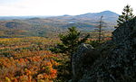
 | 8 km) foot trail (the Winslow Trail) leads from the picnic area to the summit of Mount Kearsarge. A 1.7-mile (2.7 km) trail (the Barlow Trail) offers a... 4 KB (281 words) - 01:46, 3 August 2023 |
| and receives North Boulder Creek from the right. Barlow Trail County Park and remnants of the Barlow Road lie to the right along this stretch of the river... 20 KB (2,089 words) - 23:28, 25 November 2022 |
increasing to 70 km/h (43 mph) and becomes an expressway east of Sarcee Trail. John Laurie Boulevard continues east along the southern edge of Nose Hill... 11 KB (615 words) - 08:28, 3 May 2024 |
 | trip from the park to the summit is about 1 mile by the Winslow Trail. The Barlow Trail is a longer route to the summit that allows hikers to make a loop... 16 KB (1,564 words) - 17:00, 3 May 2024 |
 | small segment of Country Hills Boulevard between Deerfoot Trail (Highway 2) and Barlow Trail was once designated as part of Highway 2A, but was decommissioned... 6 KB (281 words) - 19:46, 7 October 2023 |