
A bathymetric chart is a type of isarithmic map that depicts the submerged bathymetry and physiographic features of ocean and sea bottoms. Their primary...
9 KB (1,929 words) - 14:07, 25 May 2024
The General Bathymetric Chart of the Oceans (GEBCO) is a publicly available bathymetric chart of the world's oceans. The project was conceived with the...
8 KB (1,076 words) - 19:06, 24 May 2024

Bathymetry (redirect from Bathymetric)
are from Ancient Egypt over 3000 years ago. Bathymetric charts (not to be confused with hydrographic charts), are typically produced to support safety...
27 KB (3,776 words) - 14:08, 30 June 2024

have not been done yet. The General Bathymetric Chart of the Oceans (GEBCO) is a publicly available bathymetric chart of the world's oceans. The project...
34 KB (4,083 words) - 06:50, 27 August 2024

on-demand chart files so that these charts are up to date at the time of printing. Nautical charts are based on hydrographic surveys and bathymetric surveys...
17 KB (2,284 words) - 19:32, 18 September 2024
The International Bathymetric Chart of the Southern Ocean (IBCSO) is a regional mapping initiative of the General Bathymetric Chart of the Oceans (GEBCO)...
8 KB (797 words) - 14:26, 22 December 2023

Topographic map (redirect from Topographic chart)
allows re-use, such as a Creative Commons license. Aeronautical chart Bathymetric chart Cadastral map Thematic map Hypsometric tints International Map...
20 KB (2,043 words) - 06:29, 4 September 2024

are often drawn seaward of the actual shallowest depth portrayed. A bathymetric chart does show marine topology accurately. Details covering the above limitations...
13 KB (1,609 words) - 10:35, 8 August 2024
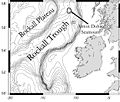
Rockall Trough (Scottish Gaelic: Clais Sgeir Rocail) is a deep-water bathymetric feature to the northwest of Scotland and Ireland, running roughly from...
9 KB (988 words) - 21:46, 21 June 2024

algorithms (software) to derive bathymetric measurements from the data recorded by the sensor. SDB methods can provide bathymetric data with varying spatial...
6 KB (604 words) - 07:56, 16 September 2024

November 2020. Retrieved 12 November 2020. Ritchie, G.S. (1967). The Admiralty Chart. London: Hollis & Carter. pp. 317–319. Richards, G.H. (1869). "Suez Canal...
127 KB (14,126 words) - 10:49, 15 September 2024

the eastern limit of this basin, nearly due south of Brenachoil. Bathymetric charts show that the soundings throughout this basin gradually increase in...
17 KB (2,163 words) - 16:25, 20 July 2024

shows a date of 1926. The topographic data supplied by the General Bathymetric Chart of the Oceans (GEBCO), however, shows a sea depth of 3.3 miles (5...
2 KB (287 words) - 15:05, 10 July 2023

in various global terrain data sets, such as the bathymetric data from the General Bathymetric Chart of the Oceans, which reported an elevation of 1 metre...
16 KB (1,822 words) - 00:49, 30 June 2024

"Map of the Black Sea bottom relief, based on the International Bathymetric Chart of the Mediterranean Sea". researchgate.net. Archived from the original...
21 KB (1,694 words) - 18:46, 14 September 2024

(20 June 2013). "The International Bathymetric Chart of the Southern Ocean (IBCSO) Version 1.0—A new bathymetric compilation covering circum-Antarctic...
114 KB (14,713 words) - 20:26, 18 September 2024
The Molloy Deep (also known as the Molloy Hole) is a bathymetric feature in the Fram Strait, within the Greenland Sea east of Greenland and about 160 km...
13 KB (1,205 words) - 10:53, 29 July 2024

Bear Lake Show map of Idaho Bear Lake Show map of the United States Bathymetric chart Location Bear Lake County, Idaho Rich County, Utah, U.S. Coordinates...
21 KB (1,877 words) - 19:21, 29 August 2024
General Bathymetric Chart of the Oceans program.[citation needed] Establishment of the Chart Specifications Committee and International Charts: The exploration...
11 KB (1,157 words) - 19:41, 3 August 2024

the south-west Pacific: a preliminary interpretation of H. O. 5484, bathymetric chart, New Guinea to New Zealand.". Proceedings of the 7th Pacific Science...
21 KB (1,901 words) - 13:38, 3 July 2024

6 July 2012. ROC reaffirms sovereignty over Huangyan Island "NGA Bathymetric Chart 91005". Retrieved 5 June 2024. Alcérreca-Huerta, Juan Carlos; Reyes-Mendoza...
26 KB (3,005 words) - 19:54, 12 July 2024

S-102 on Bathymetric Surfaces, S-111 on Surface Currents and S-124 on Navigational Warnings. e-Navigation concept Raster Navigational Charts (NOAA) Navionics...
15 KB (1,631 words) - 17:37, 26 August 2024

Bathymetric chart around Iwo Jima (by the Japan Coast Guard)...
55 KB (5,890 words) - 05:11, 7 September 2024
resonance Tide gauge Tideline Landforms Abyssal fan Abyssal plain Atoll Bathymetric chart Carbonate platform Coastal geography Cold seep Continental margin...
1 KB (119 words) - 00:52, 23 May 2023

Canyon, an undersea feature in the Ross Sea, appears on the General Bathymetric Chart of the Oceans, published by the International Hydrographic Organization...
74 KB (7,143 words) - 22:38, 4 September 2024

doi:10.1175/JPO-D-18-0243.1. ISSN 0022-3670. S2CID 195545808. "Global bathymetric chart of the ocean". "CMEMs data base". Copernicus. Pennelly, Clark; Myers...
17 KB (2,005 words) - 07:36, 18 January 2024

feature was discovered by Matthew Fontaine Maury while producing a bathymetric chart of the ocean in 1853, compiled from sounding data from multiple ships'...
6 KB (886 words) - 15:49, 6 February 2023

Virginia Military Institute, 1869 Earth sciences portal Virginia portal Bathymetric chart Flying Cloud National Institute for the Promotion of Science Notable...
44 KB (5,128 words) - 03:32, 27 August 2024

parts of the International Hydrographic Organization (IHO) General Bathymetric Chart of the Oceans (GEBCO) gazetteer for under-sea features situated south...
4 KB (308 words) - 00:48, 24 August 2024

(September 2003). "Proposal for the preparation of a new International Bathymetric Chart of the Southern Ocean" (PDF). IHO International Hydrographic Committee...
49 KB (6,556 words) - 16:26, 28 May 2024