 | Bathymetry (/bəˈθɪmətri/; from Ancient Greek βαθύς (bathús) 'deep', and μέτρον (métron) 'measure') is the study of underwater depth of ocean floors (seabed... 27 KB (3,759 words) - 17:47, 15 March 2024 |
 | Lidar (redirect from Airborne laser bathymetry) frequency doubled solid-state IR laser output is the standard for airborne bathymetry. This light can penetrate water but pulse strength attenuates exponentially... 128 KB (14,556 words) - 09:51, 5 April 2024 |
 | Satellite-Derived Bathymetry (SDB) is the calculation of shallow water depth from active or passive satellite sensors. The technology requires a sensor... 6 KB (615 words) - 09:59, 19 March 2024 |
 | bathymetric profiles which are vertical sections through a feature. The use of bathymetry and the development of bathymetric charts dates back around the 19th century... 9 KB (1,920 words) - 18:30, 14 January 2024 |
 | Challenger Deep (section Surveys and bathymetry) submersibles, remotely operated underwater vehicles, benthic landers, and sonar bathymetry. The differences in depth estimates and their geodetic positions are scientifically... 173 KB (19,837 words) - 20:33, 10 April 2024 |
 | Diamantina Fracture Zone (section Bathymetry) which are believed to be new species. The first high-resolution multibeam bathymetry of the central DFZ was collected between June 2014 and June 2016, for... 7 KB (850 words) - 19:23, 3 September 2023 |
 | Lake Huron (category Articles using infobox body of water without alt bathymetry) Huron Michigan lighthouses National Geophysical Data Center (1999). "Bathymetry of Lake Erie and Lake Saint Clair". National Oceanographic and Atmospheric... 31 KB (3,175 words) - 13:20, 27 April 2024 |
 | measurement of altitude is called altimetry, which is related to the term bathymetry, the measurement of depth under water. Altitude can be determined based... 6 KB (731 words) - 06:05, 4 October 2023 |
 | Bathymetry of the ocean floor showing the continental shelves and oceanic plateaus (red), the mid-ocean ridges (yellow-green) and the abyssal plains (blue... 33 KB (4,185 words) - 21:14, 15 April 2024 |
 | Sherman; MacLeod, Christopher; Taylor, Brian; Goodliffe, Andrew (2000). "Bathymetry of the Tonga Trench and Forearc: A Map Series". Marine Geophysical Researches... 266 KB (22,127 words) - 06:37, 1 May 2024 |
 | Mariana Trough (section Location and Bathymetry) the mantle. Where not covered by sediments, the seafloor is deeper and bathymetry more rugged than normal. The most recent, "zero-age" seafloor of the Philippine... 8 KB (1,041 words) - 19:10, 15 July 2021 |
 | MR1 mapping system. This mapping system has the ability to record both bathymetry and sidescan data at the same time. The two vessels that this system was... 11 KB (1,008 words) - 08:43, 28 April 2024 |
 | Pfirman, Stephanie; Schenke, Hans Werner; Reil, Wolfgang (1990-08-01). "Bathymetry of Molloy Deep: Fram Strait between Svalbard and Greenland". Mar. Geophys... 9 KB (856 words) - 22:01, 6 September 2023 |
 | Bénard et al. 2010, Introduction, pp. 1–2 NOAA Bathymetry Viewer https://maps.ngdc.noaa.gov/viewers/bathymetry/ Bénard et al. 2010, Geological and plate boundary... 23 KB (2,418 words) - 17:27, 5 March 2024 |
 | and the global oceanic circulation, as well as the global climate. The bathymetry of the Drake Passage plays an important role in the global mixing of oceanic... 24 KB (2,628 words) - 01:02, 17 April 2024 |
 | Lake Victoria (category Articles using infobox body of water without image bathymetry) Anthony Munyaho; Noah, Krach; Sarah, Glaser (17 May 2018). "Bathymetry TIFF, Lake Victoria Bathymetry, raster, 2017, V7" (Data Set). Harvard Dataverse. doi:10... 72 KB (8,072 words) - 12:34, 26 February 2024 |
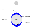 | Tide (section Bathymetry) systems of the oceans, and the shape of the coastline and near-shore bathymetry (see Timing). They are however only predictions, the actual time and height... 109 KB (13,054 words) - 12:33, 17 February 2024 |
 | Great Lakes (category Articles using infobox body of water without alt bathymetry) 2010. From left to right: Lake Superior, Michigan, Huron, Erie, Ontario Bathymetry map of the Great Lakes Location Eastern North America Coordinates 45°N... 115 KB (11,914 words) - 14:45, 21 April 2024 |
 | internal structure of Earth is based on observations of topography and bathymetry, observations of rock in outcrop, samples brought to the surface from... 31 KB (3,015 words) - 01:34, 25 April 2024 |
Tidal scour (section Bathymetry) bathymetry over time. Bathymetry of tidal channels is determined using multi-beam sonar or LiDAR. By comparing cross-sections of channel bathymetry over... 6 KB (665 words) - 12:07, 24 May 2023 |
 | Bathymetry of the Palk Strait, showing water depth in metres... 29 KB (3,097 words) - 03:32, 30 January 2024 |
 | Bering Strait (category Articles using infobox body of water without alt bathymetry) The Bering Strait (Russian: Берингов пролив, romanized: Beringov proliv) is a strait between the Pacific and Arctic oceans, separating the Chukchi Peninsula... 20 KB (2,120 words) - 11:50, 17 April 2024 |
 | Algoa Bay (category Articles using infobox body of water without image bathymetry) Algoa Bay is a maritime bay in the Eastern Cape, South Africa. It is located on the east coast, 683 kilometres (424 mi) east of the Cape of Good Hope.... 16 KB (2,177 words) - 00:20, 12 February 2024 |
 | Lake Michigan (category Articles using infobox body of water without alt bathymetry) Traverse Bay Port of Milwaukee National Geophysical Data Center, 1996. Bathymetry of Lake Michigan. National Geophysical Data Center, NOAA. doi:10.7289/V5B85627... 51 KB (5,058 words) - 19:03, 1 May 2024 |
thick craton with no active volcanism after the Proterozoic, and regional bathymetry explains the "runway" formation under the anomaly as part of a larger... 11 KB (1,185 words) - 17:22, 23 April 2024 |
Marine geology (section Multibeam bathymetry) generate a more detailed survey. Similarly to side-scan sonar, multibeam bathymetry uses a transducer array to send and receive sound waves in order to detect... 57 KB (6,326 words) - 04:16, 25 April 2024 |
 | Nepheloid layer (section Bathymetry) Nepheloid layers can impact the accuracy of instruments when measuring bathymetry as well as affect the types of marine life in an area. There are several... 7 KB (906 words) - 20:48, 13 August 2023 |
 | NOAA Bathymetry Image of Puerto Rico (2020)... 321 KB (32,665 words) - 12:14, 1 May 2024 |
 | Pacific Ocean (category Articles using infobox body of water without image bathymetry) The Pacific Ocean is the largest and deepest of the Earth's five oceanic divisions. It extends from the Arctic Ocean in the north to the Southern Ocean... 78 KB (8,328 words) - 22:50, 1 May 2024 |
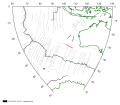
 | Bransfield Basin Bathymetry map of the Bransfield Basin created using Geomap App software with a bathymetry map overlay with a distance and elevation scale... 18 KB (1,744 words) - 03:59, 26 November 2023 |