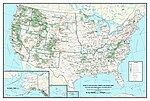
 | The Beaverhead–Deerlodge National Forest is the largest of the National Forests in Montana, United States. Covering 3.36 million acres (13,600 km2), the... 9 KB (811 words) - 20:28, 9 January 2024 |
 | Sphinx Mountain is visible. The surrounding lands are part of Beaverhead–Deerlodge National Forest. "Cameron". Montana Place Names Companion. Montana Historical... 2 KB (123 words) - 05:44, 14 November 2023 |
 | Silver Bow County, six miles south-southeast of Butte in Beaverhead-Deerlodge National Forest at an elevation of 6,329 feet (1,929 m). The pass carries... 4 KB (414 words) - 03:07, 12 January 2024 |
 | 2012. "Beaverhead–Deerlodge National Forest". U.S. Forest Service. Retrieved October 15, 2012. "National Forests in Mississippi". U.S. Forest Service... 116 KB (2,714 words) - 14:10, 30 January 2024 |
in the Rocky Mountains at the continental divide in the Beaverhead-Deerlodge National Forest in western Jefferson County. It flows east and southeast... 6 KB (267 words) - 22:49, 23 April 2022 |
 | the Little Blackfoot River, and serves as a gateway to the Beaverhead-Deerlodge National Forest. The post office was opened in 1884 by Bill Cramer. The town... 6 KB (512 words) - 23:48, 9 September 2023 |
 | in the Tobacco Root Mountains. The mountain is located in Beaverhead-Deerlodge National Forest. (There is also another Mount Jefferson in Montana, further... 7 KB (987 words) - 14:13, 29 June 2023 |
 | Tobacco Root Mountains (category Beaverhead-Deerlodge National Forest) range is within the Beaverhead-Deerlodge National Forest, although many—mostly small—patented mining claims exist within the forest boundary. The range... 9 KB (1,165 words) - 21:25, 3 April 2024 |
 | portions of the Beaverhead, Salmon, and Targhee National Forests. Scott Peak, el. 11,393 feet, the highest point in the Beaverheads, is in this roadless... 9 KB (641 words) - 21:53, 18 October 2023 |
 | today is famous for trout fishing. It is located in the Beaverhead–Deerlodge National Forest. According to the Köppen Climate Classification system, Melrose... 2 KB (164 words) - 12:32, 28 August 2023 |
 | 66,000 acres in size. Nearly all the range is part of the Beaverhead-Deerlodge National Forest. In the northern part of the range is the Bureau of Land... 6 KB (371 words) - 22:14, 25 November 2023 |
 | County, Montana, 10 miles (16 km) south of Butte, Montana, in Beaverhead-Deerlodge National Forest, at an elevation of 6,453 feet (1,967 m). The Chicago, Milwaukee... 2 KB (266 words) - 14:39, 10 April 2023 |
 | Anaconda–Pintler Wilderness (category Beaverhead-Deerlodge National Forest) jointly by the Beaverhead-Deerlodge and Bitterroot National Forests. In 1964, Montana's Senator Mike Mansfield requested the National Park Service study... 6 KB (497 words) - 01:40, 7 July 2022 |
 | Management land), as indicated. Anaconda–Pintler Wilderness (partly in Beaverhead NF, Deerlodge NF) Frank Church–River of No Return Wilderness (partly in Payette... 11 KB (1,078 words) - 02:23, 9 January 2024 |
 | is located in Lee Metcalf Wilderness within Gallatin and Beaverhead-Deerlodge National Forests. Lone Mountain is 16.63 mi (26.76 km) north of Koch Peak... 2 KB (133 words) - 02:41, 18 December 2023 |
 | Madison Range (category Beaverhead-Deerlodge National Forest) Yellowstone Ecosystem. Most of the range lies within Beaverhead-Deerlodge and Gallatin National Forests. A small portion of the range has been further protected... 5 KB (333 words) - 14:20, 3 December 2023 |
 | Lee Metcalf Wilderness (category Beaverhead-Deerlodge National Forest) sections of the wilderness are jointly managed by Beaverhead-Deerlodge and Gallatin National Forests, both of which are a part of the Department of Agriculture... 8 KB (418 words) - 23:49, 23 November 2023 |
 | In the United States, national forest is a classification of protected and managed federal lands that are largely forest and woodland areas. They are owned... 13 KB (1,377 words) - 00:23, 19 April 2024 |
 | Big Hole Pass (category Landforms of Beaverhead County, Montana) Montana State Highway 43 in the Beaverhead–Deerlodge National Forest in Beaverhead County, Montana, and Salmon National Forest in Lemhi County, Idaho. Note:... 4 KB (369 words) - 21:16, 12 March 2023 |
| Lemhi Pass (category Beaverhead-Deerlodge National Forest) mountain pass in the Beaverhead Mountains, part of the Bitterroot Range in the Rocky Mountains and within Salmon-Challis National Forest. The pass lies on... 7 KB (734 words) - 12:15, 21 February 2024 |
 | Continental Divide Trail (redirect from Continental Divide National Scenic Trail) Divide National Scenic Trail in Rocky Mountain National Park (National Park Service) Jonathan Ley's CDT Hike - a hiker's website Beaverhead-Deerlodge National... 40 KB (4,723 words) - 18:34, 25 March 2024 |
 | Monida Pass (category Landforms of Beaverhead County, Montana) Climbing Guide - 76. Retrieved 4 March 2007. USDA Forest Service - Beaverhead-Deerlodge National Forest - Cultural Resources at the Wayback Machine (archived... 6 KB (430 words) - 10:48, 2 March 2023 |
 | Jefferson County - east Madison County - south Beaverhead County - southwest Beaverhead–Deerlodge National Forest (part) As of the 2020 census, there were 35... 14 KB (995 words) - 00:31, 26 April 2024 |
 | Highland Mountains in Madison County, Montana. It is located in Beaverhead-Deerlodge National Forest. Headwaters of Moose Creek, Fish Creek and Hell's Canyon... 2 KB (80 words) - 17:03, 8 October 2018 |
 | narrow canyon. The community is largely surrounded by the Beaverhead-Deerlodge National Forest. Basin Creek flows south through the center of Basin to its... 35 KB (3,766 words) - 21:22, 25 April 2024 |
 | Conrow Fire (category Beaverhead-Deerlodge National Forest) wildfire that burned seven miles northeast of Whitehall in the Beaverhead–Deerlodge National Forest in Montana in the United States. The fire was started by... 5 KB (427 words) - 05:48, 3 December 2023 |
 | remote section of the Lee Metcalf Wilderness within the Beaverhead-Deerlodge National Forest. The peak was first climbed in 1948. The peak was named for... 2 KB (122 words) - 07:02, 30 January 2022 |
 | Cedar Mountain (Montana) (category Beaverhead-Deerlodge National Forest) set within the Lee Metcalf Wilderness on land managed by Beaverhead–Deerlodge National Forest. The mountain has an east peak (10,768-ft), as well as the... 4 KB (302 words) - 02:22, 18 December 2023 |
Caribou-Targhee National Forest that borders Yellowstone National Park. Other sequences were shot in the Beaverhead-Deerlodge National Forest. The summer... 13 KB (1,508 words) - 14:41, 23 December 2022 |
| Custer National Forest (1908) Madison National Forest, now part of Beaverhead, Gallatin and Deerlodge National Forests (1931) Missoula National Forest, now... 9 KB (1,434 words) - 10:11, 16 July 2023 |