 | Beaverhead County is the largest county by area in the U.S. state of Montana. As of the 2020 census, the population was 9,371. Its county seat is Dillon... 15 KB (1,034 words) - 17:09, 24 February 2024 |
 | Bannack is a ghost town in Beaverhead County, Montana, United States, located on Grasshopper Creek, approximately 11 miles (18 km) upstream from where... 16 KB (1,310 words) - 04:08, 22 November 2023 |
 | Dillon is a city in and the county seat of Beaverhead County, Montana, United States. The population was 3,880 at the 2020 census. The city was named... 27 KB (2,005 words) - 05:48, 19 February 2024 |
(secondary coordinates) There are at least 158 named mountains in Beaverhead County, Montana. Ajax Peak, 45°19′52″N 113°44′19″W / 45.33111°N 113.73861°W... 29 KB (6,897 words) - 15:54, 20 March 2022 |
 | The Beaverhead impact structure is the second largest impact structure within the U.S. It lies within the states of Idaho and Montana. Estimated at 60... 2 KB (183 words) - 20:06, 17 March 2024 |
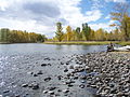
 | The Beaverhead River is an approximately 69-mile-long (111 km) tributary of the Jefferson River in southwest Montana (east of the Continental Divide).... 6 KB (443 words) - 05:05, 21 December 2022 |
Arrowhead Mountain is a 6,936-foot (2,114 m) mountain in Beaverhead County, Montana, United States. "Arrowhead Mountain". Geographic Names Information... 352 bytes (56 words) - 16:36, 27 November 2023 |
 | states of Montana and Idaho. (See also the GNIS link here.) They are a sub-range of the Bitterroot Range, and divide Beaverhead County, Montana from Lemhi... 9 KB (641 words) - 21:53, 18 October 2023 |
 | Big Hole River (category Rivers of Beaverhead County, Montana) Jefferson River, approximately 153 miles (246 km) long, in Beaverhead County, in southwestern Montana, United States. It is the last habitat in the contiguous... 18 KB (1,758 words) - 15:01, 15 September 2023 |
 | The Beaverhead–Deerlodge National Forest is the largest of the National Forests in Montana, United States. Covering 3.36 million acres (13,600 km2), the... 9 KB (811 words) - 20:28, 9 January 2024 |
 | Beaverhead Rock, also known as Point of Rocks, is a rock formation overlooking the Beaverhead River in Montana protected as Beaverhead Rock State Park... 4 KB (322 words) - 05:54, 1 August 2023 |
 | Beaverhead County High School is a high school in the small town of Dillon, Beaverhead County, Montana. The Dillon Beavers have been the Class "A" State... 3 KB (233 words) - 21:29, 7 April 2024 |
Montana is in Beaverhead County, Montana, between Dell and Redrock, along Interstate 15 going north towards Dillon, Montana, 59725. "Kidd (Beaverhead... 592 bytes (48 words) - 17:23, 21 August 2023 |
 | Pioneer Mountains cover 2,000 square miles (5,200 km2) in Beaverhead County in southwestern Montana, USA. The highest peaks in this range include: Tweedy... 6 KB (501 words) - 13:50, 4 October 2023 |
 | Mountain is a 9,688-foot elevation (2,953 m) mountain summit in Beaverhead County, Montana, United States. Sheep Mountain is the seventh-highest peak in... 4 KB (305 words) - 14:28, 29 June 2023 |
Wise River (category Rivers of Beaverhead County, Montana) in southwestern Montana in the United States. It rises in the Beaverhead National Forest in the Pioneer Mountains in Beaverhead County. It flows NNW through... 3 KB (164 words) - 22:43, 23 April 2022 |
(secondary coordinates) There are at least 20 named trails in Beaverhead County, Montana according to the U.S. Geological Survey, Board of Geographic Names... 6 KB (1,151 words) - 01:23, 11 April 2022 |
Jackson is an unincorporated community in Beaverhead County, Montana, United States. Jackson has a post office with a ZIP code 59736. As of the 2020 census... 9 KB (256 words) - 21:41, 25 November 2023 |
| Lemhi Pass (category Landforms of Beaverhead County, Montana) the Beaverhead Mountains, part of the Bitterroot Range in the Rocky Mountains and within Salmon-Challis National Forest. The pass lies on the Montana-Idaho... 7 KB (734 words) - 12:15, 21 February 2024 |
 | Monida is an unincorporated community in Beaverhead County, Montana, United States. Monida is located on Interstate 15 at the top of Monida Pass, 14.7... 3 KB (129 words) - 23:53, 19 November 2023 |
45 streams named Willow Creek in the U.S. state of Montana. Willow Creek (Beaverhead County, Montana), 44°39′02″N 112°39′00″W / 44.65056°N 112.65000°W... 9 KB (2,119 words) - 04:58, 19 February 2021 |
 | Creek, originates in the Beaverhead National Forest within a few hundred meters of the North American Continental Divide and Montana-Idaho border near Brower's... 4 KB (288 words) - 02:46, 12 June 2022 |
 | east into Montana, between Chief Joseph Pass and Lost Trail Pass, and follows the Ravalli County-Beaverhead County border. Ravalli County was once home... 14 KB (1,029 words) - 11:05, 17 April 2024 |
Wise River is an unincorporated community in northern Beaverhead County, Montana, United States. State Highway 43 runs through the town. This community... 7 KB (182 words) - 00:24, 22 November 2023 |
 | Monida Pass (category Landforms of Beaverhead County, Montana) eastern Idaho and southwestern Montana, and is between the towns of Spencer in Clark County and Lima in Beaverhead County. On the Idaho side is Beaver Creek... 6 KB (430 words) - 10:48, 2 March 2023 |
the Snowcrest Range in southern Beaverhead County. It flows northwest, joining the Beaverhead River near Dillon, Montana. The creek contains rainbow, brook... 3 KB (213 words) - 17:39, 14 January 2024 |
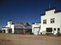 | Wisdom is a small town in Beaverhead County, Montana, United States. The population was 98 at the 2010 census. The ZIP Code of the area is 59761. The town... 18 KB (1,187 words) - 20:21, 17 March 2024 |
 | -113.76639 (Ahern Pass), el. 7,116 feet (2,169 m) Alder Pass, Beaverhead County, Montana, 45°44′42″N 113°10′04″W / 45.74500°N 113.16778°W / 45.74500;... 33 KB (7,526 words) - 18:06, 7 March 2024 |
 | list of the National Register of Historic Places listings in Beaverhead County, Montana. It is intended to be a complete list of the properties and districts... 11 KB (366 words) - 14:18, 9 August 2023 |
 | the Continental Divide between Fremont County of northeastern Idaho and Beaverhead County of southwestern Montana. Mount Jefferson is the highest point... 3 KB (242 words) - 09:46, 23 December 2021 |