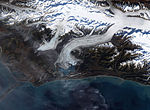
 | Bering Glacier is a glacier in the U.S. state of Alaska. It currently terminates in Vitus Lake south of Alaska's Wrangell-St. Elias National Park, about... 4 KB (457 words) - 19:59, 8 April 2023 |
 | coast on the North American continent. The Bering Strait, the Bering Sea, Bering Island, the Bering Glacier, and Vitus Lake were all named in his honor... 39 KB (5,599 words) - 20:25, 1 February 2024 |
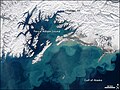
river begins at Vitus Lake, which takes in meltwater from mouth of the Bering Glacier, and flows southwest to the Gulf of Alaska. List of rivers of Alaska... 2 KB (85 words) - 12:37, 21 July 2021 |
 | form of glacier ice, covers some 16,000 square miles (41,000 km2) of land and 1,200 square miles (3,100 km2) of tidal zone. The Bering Glacier complex... 19 KB (2,095 words) - 15:21, 6 March 2024 |
 | Bagley Icefield (category Glaciers of Chugach Census Area, Alaska) recognize that the huge glacier now named Bagley Icefield actually forms the upper reaches of the distant and similarly vast Bering Glacier, which had been named... 4 KB (295 words) - 19:00, 27 February 2024 |
 | a number of tidewater glaciers. Alaska's largest glaciers, the Malaspina Glacier and Bering Glacier, spill out onto the coastal line along the Gulf of... 13 KB (1,145 words) - 16:57, 28 April 2024 |
 | Glacial erratic (section Glacier-borne erratic) They can be transported by glaciers, and are thereby one of a series of indicators which mark the path of prehistoric glacier movement. Their lithographic... 30 KB (3,378 words) - 19:39, 5 January 2024 |
 | The Bering Strait (Russian: Берингов пролив, romanized: Beringov proliv) is a strait between the Pacific and Arctic oceans, separating the Chukchi Peninsula... 20 KB (2,120 words) - 11:50, 17 April 2024 |
 | Beringia (redirect from Bering Land Bridge) tip of the Kamchatka Peninsula. It includes the Chukchi Sea, the Bering Sea, the Bering Strait, the Chukchi and Kamchatka Peninsulas in Russia as well as... 45 KB (5,892 words) - 00:22, 26 March 2024 |
geodetic method. Runoff from Bering Glacier (derived from simulated ablation and rain) correlates with four of the glacier surges that have occurred since... 6 KB (835 words) - 20:51, 2 October 2020 |
 | determine the balance of the Bering and Hubbard Glaciers and is also validated for the Gulkana, a USGS benchmark glacier. Global warming portal Ecology... 42 KB (5,031 words) - 07:11, 22 April 2024 |
 | the Knik and Turnagain Arms of the Cook Inlet on the west to Bering Glacier, Tana Glacier, and the Tana River on the east. It is bounded on the north by... 10 KB (1,008 words) - 16:07, 26 September 2023 |
 | Behavior of the Bering Glacier-Bagley Icefield System During a Surge". European Space Agency. Retrieved 2010-06-14. "Nabesna Glacier (Wrangell-St. Elias... 4 KB (370 words) - 18:36, 29 June 2022 |
 | Barnard Glacier Bear Glacier - Aialik Peninsula, Resurrection Bay Bering Glacier Black Rapids Brady Glacier Brooks Glacier - Alaska Range Buckskin Glacier -... 26 KB (2,388 words) - 22:41, 9 February 2024 |
 | Mendenhall Glacier (in Tlingit language “Sít”) is a glacier about 13.6 miles (21.9 km) long located in Mendenhall Valley, about 12 miles (19 km) from downtown... 15 KB (1,500 words) - 14:23, 1 March 2024 |
 | southwest flatlands). Glacier ice covers about 28,957 square miles (75,000 km2) of Alaska. The Bering Glacier is the largest glacier in North America, covering... 191 KB (17,166 words) - 16:34, 2 May 2024 |
 | was adopted after the retreat of Guyot Glacier resulted in a separate branch. List of glaciers "USGS Bering Glacier B-2 (AK) Topo Map". Topozone. Retrieved... 2 KB (110 words) - 18:46, 25 May 2022 |
 | -2 °C, and the coldest month is January, at -20 °C. List of glaciers "USGS Bering Glacier C-5 (AK) Topo Map". Topozone. Retrieved 2007-01-24. "NASA Earth... 2 KB (118 words) - 20:42, 24 July 2023 |
 | A supraglacial lake is any pond of liquid water on the top of a glacier. Although these pools are ephemeral, they may reach kilometers in diameter and... 8 KB (1,153 words) - 16:04, 8 January 2024 |
 | The Bering Land Bridge National Preserve is one of the most remote Protected areas of the United States, located on the Seward Peninsula. The National... 26 KB (2,701 words) - 14:08, 24 December 2023 |
 | Tracy Arm (redirect from Sawyer Glacier) the most recent glaciated period, both fjords were filled with active glaciers. The most common access is by boat using Stephens Passage and entering... 6 KB (574 words) - 20:15, 25 November 2023 |
 | northeast of Cordova, and 20 mi (32 km) north of the Bering Glacier, North America's largest glacier. The mountain lies within the Copper River drainage... 5 KB (463 words) - 17:07, 28 March 2024 |
 | local terrain. For example, it rises 8,000 feet (2,400 m) above the Bering Glacier to the south in about 4 horizontal miles (6.4 km). Mount Steller is... 4 KB (375 words) - 01:30, 23 December 2023 |
 | Glacier Bay National Park and Preserve is an American national park located in Southeast Alaska west of Juneau. President Calvin Coolidge proclaimed the... 44 KB (4,649 words) - 00:50, 1 April 2024 |
 | The mountain is surrounded by the Leeper Glacier, Guyot Glacier, Yahtse Glacier, and smaller unnamed glaciers. Precipitation runoff and glacial meltwater... 6 KB (487 words) - 15:36, 5 March 2024 |
 | Wisconsin glaciation (redirect from Wisconsin Glacier) including humans, to occupy Beringia (the Bering Land Bridge) and move between North America and Siberia. As the glaciers retreated, glacial lakes were breached... 16 KB (1,491 words) - 08:31, 2 May 2024 |
 | hydrological divide of the Americas. The Continental Divide extends from the Bering Strait to the Strait of Magellan, and separates the watersheds that drain... 21 KB (2,397 words) - 21:25, 4 January 2024 |
tributary of the Kesagami River United States - Alaska Seal River (Bering Glacier) Seal River (Cook Inlet) Little Seal River (Ontario) This disambiguation... 358 bytes (82 words) - 13:32, 4 December 2017 |
 | ice advance? What 15 year of post-surge retreat have revealed beneath Bering Glacier, Alaska, GSA Abstracts with Programs, Abstract #247-8 Cuvier & Brongniart... 23 KB (3,084 words) - 07:08, 12 December 2023 |
 | rises above the Columbus Glacier and Bagley Icefield to its north, the Tyndall Glacier to the south, and the Yahtse Glacier to the west. Precipitation... 5 KB (429 words) - 02:39, 28 June 2023 |