
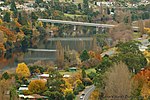
Blackmans Bay is a coastal suburb of Kingborough Council, Tasmania, Australia. It forms part of the Kingston-Blackmans Bay urban area and is a satellite...
9 KB (749 words) - 11:51, 9 February 2024
147.861 Blackman Bay is located on the south-east coast of Tasmania. It extends from the bay's inlet at the southern peninsula of Marion Bay to the village...
2 KB (191 words) - 10:30, 28 May 2022
Marion Bay is a rural / residential locality in the local government area (LGA) of Sorell in the South-east LGA region of Tasmania. The locality is about...
6 KB (608 words) - 23:05, 27 March 2024
regions in Tasmania. The Kingston-Huntingfield statistical area had an estimated population of 13,473 in June 2021. Although the Kingston-Blackmans Bay region...
9 KB (706 words) - 12:01, 9 February 2024

different) Blackmans Bay, and the following year Tobias Furneaux became the first Englishman to land in Tasmania when he arrived at Adventure Bay, which he...
183 KB (15,463 words) - 16:45, 20 May 2024
Bay, Barnes Bay, Dennes Point, Great Bay, Killora, Lunawanna, North Bruny, Simpsons Bay, and South Bruny; the Hobart suburbs of Blackmans Bay, Bonnet Hill...
25 KB (1,180 words) - 15:59, 7 May 2024

Retrieved 1 June 2023. Tasmania. Town and Country Planning Commission; Bolt, Frank, 1928- (1956), Kingston, Kingston Beach, & Blackmans Bay (Add. Sept. '56 ed...
6 KB (497 words) - 23:04, 27 March 2024
Kingborough Council (redirect from Kingborough Council, Tasmania)
• Blackmans Bay • Bonnet Hill • Howden • Huntingfield • Kingston • Kingston Beach • Taroona • Adventure Bay • Allens Rivulet • Alonnah • Apollo Bay •...
9 KB (652 words) - 07:03, 27 November 2023
Norfolk Bay is a body of water in the south east of Tasmania, Australia. The north west aspect of Norfolk Bay is continuous with Frederick Henry Bay. The...
7 KB (620 words) - 00:03, 26 December 2023

purchased Hobart Coaches which operated services to New Norfolk, Richmond, Blackmans Bay and the Channel areas of Hobart. Hobart Coaches was retained as the...
32 KB (4,303 words) - 13:11, 27 September 2023
of Tasmania. Dunalley was gazetted as a locality in 1967. The Denison canal, with a swing bridge for road traffic, has been cut between Dunalley Bay and...
7 KB (521 words) - 04:15, 13 December 2023
Boomer Bay is a rural locality in the local government area (LGA) of Sorell in the South-east LGA region of Tasmania. The locality is about 27 kilometres...
3 KB (195 words) - 08:19, 6 May 2024

Nutgrove Beach (redirect from Nutgrove, Tasmania)
is a popular beach destination along the River Derwent in Sandy Bay, Hobart, Tasmania. The north facing beach has views of kunanyi / Mount Wellington...
8 KB (625 words) - 04:10, 24 November 2023
Protected areas of Tasmania consist of protected areas located within Tasmania and its immediate onshore waters, including Macquarie Island. It includes...
70 KB (4,158 words) - 03:28, 11 January 2024
693.1204. doi:10.1080/10889370802579856. S2CID 128640917. Winter Quarters Bay is the world's southernmost port. David Rootes (1988). A concise account...
45 KB (1,817 words) - 12:55, 12 March 2024
Huntingfield. It is an outer suburb of the greater Hobart area, bordering Blackmans Bay and Kingston. The area was created in the late 1980s. Located in Huntingfield...
5 KB (319 words) - 12:00, 9 February 2024

Abel Tasman (category Explorers of Tasmania)
Tasman skirted the southern end of Tasmania and turned north-east. He then tried to work his two ships into Adventure Bay on the east coast of South Bruny...
37 KB (4,312 words) - 03:17, 16 May 2024

walking tracks and overlooks the coastal suburbs of Kingston Beach and Blackmans Bay. Maranoa Heights is home to the Boronia Hill Flora Track. Development...
3 KB (206 words) - 02:59, 11 February 2024
the Channel Highway between North-West Bay and the Snug Tiers, 7 kilometres (4 mi) south of Kingston in Tasmania, Australia. It is mostly in the Kingborough...
7 KB (785 words) - 07:26, 29 September 2023

on the Channel Highway located 30 kilometres (19 mi) south of Hobart in Tasmania, Australia. At the 2021 census, Snug had a population of 1440. Snug is...
7 KB (680 words) - 03:13, 11 February 2024
subsidiary company of Hazell Bros with services starting in the Kingston and Blackmans Bay, D'Entrecasteaux Channel, Huon, Richmond and New Norfolk areas. From...
3 KB (330 words) - 08:37, 6 May 2024

Road is a major link road, connecting the residents of Blackmans Bay to Kingston in Southern Tasmania, Australia. The road was constructed in 1986 as a two...
2 KB (105 words) - 14:16, 8 December 2021
East Bay Neck refers to an isthmus connecting the Forestier Peninsula to the mainland of Tasmania. East Bay Neck is formed by Dunalley Bay on the west...
684 bytes (82 words) - 11:52, 3 May 2022
tombolo connects the landmass to the mainland in Boomer Bay, which itself lies within Blackman Bay. The island can be seen in several public photographs...
6 KB (177 words) - 21:00, 18 October 2022
local government area (LGA) of Kingborough in the Hobart LGA region of Tasmania. The locality is about 12 kilometres (7.5 mi) south of the town of Kingston...
7 KB (658 words) - 12:15, 6 May 2024
Shipwrecks of Tasmania are shipwrecks which have occurred in and around the island state of Tasmania, Australia. Tasmania is an island and since the time...
20 KB (2,359 words) - 04:13, 13 May 2024
New Norfolk (redirect from New Norfolk, Tasmania)
(Leenowwenne/palawa kani: wulawali) is a town on the River Derwent, in the south-east of Tasmania, Australia. With a population of 6,153 in 2021, New Norfolk is the principal...
23 KB (2,366 words) - 12:05, 23 April 2024
Thelymitra erosa (category Orchids of Tasmania)
1998 by David Jones and Mark Clements from a specimen collected near Blackmans Bay and the description was published in Australian Orchid Research. The...
3 KB (396 words) - 11:21, 29 April 2021

Van Diemen's Land (category Colonial history of Tasmania)
European to land on the shores of Tasmania. After landing at Blackman Bay and later raising the Dutch flag at North Bay, Tasman named the island Anthoonij...
28 KB (3,186 words) - 17:15, 8 May 2024
City of Glenorchy (category Local government areas of Tasmania)
Glenorchy City Council (or City of Glenorchy) is a local government body in Tasmania, and one of the five municipalities that constitutes the Greater Hobart...
12 KB (1,020 words) - 09:59, 7 May 2024