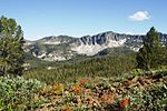
 | Boise National Forest is a National Forest covering 2,203,703 acres (8,918.07 km2) of the U.S. state of Idaho. Created on July 1, 1908, from part of Sawtooth... 62 KB (5,842 words) - 02:24, 9 January 2024 |
attack submarine Boise National Forest, a US national forest north and east of the city of Boise, Idaho Boise River Reuben P. Boise (1819-1907), former... 792 bytes (137 words) - 17:32, 21 June 2022 |
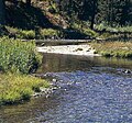
 | diverse habitats, including alpine canyons, forest, rangeland, agricultural lands, and urban areas. The Boise River rises in three separate forks in the... 14 KB (1,253 words) - 14:05, 13 January 2024 |
 | The Boise Mountains are a mountain range in the U.S. state of Idaho, spanning part of Boise and Sawtooth national forests. The highest point in the range... 3 KB (146 words) - 17:39, 4 September 2022 |
 | Frank Church–River of No Return Wilderness (category Boise National Forest) that their total is 39.59%) Boise National Forest (14.06%) Bitterroot National Forest (8.18%) Nez Perce National Forest (4.68%) Bureau of Land Management... 17 KB (1,546 words) - 23:04, 29 April 2024 |
 | south Ada County - southwest Gem County - northwest Boise National Forest (part) Sawtooth National Recreation Area (part) Sawtooth Wilderness (part) SH-21... 27 KB (2,391 words) - 00:29, 24 April 2024 |
 | based in the city of Boise and the Boise Airport is used for logistical support. The United States Forest Service (USFS) also uses Boise Airport as a base... 54 KB (4,416 words) - 05:32, 2 May 2024 |
 | Warm Lake (category Boise National Forest) feet (1,615 m) above sea level. It is the largest natural lake in Boise National Forest. The lake's abundance of wildlife makes it very popular for camping... 3 KB (235 words) - 01:00, 25 May 2023 |
 | 15, 2012. "Black Hills National Forest". U.S. Forest Service. Retrieved October 15, 2012. "Boise National Forest". U.S. Forest Service. Retrieved October... 116 KB (2,714 words) - 14:10, 30 January 2024 |
 | Lake Cascade (category Boise National Forest) Fork of the Payette River in Valley County, Idaho. Located in the Boise National Forest, it has a surface area of 47 square miles (122 km2), and is the... 7 KB (571 words) - 07:11, 19 September 2023 |
When three people are found dead in a remote region of Idaho's Boise National Forest and a fourth is reported missing, the BAU sets out to profile and... 31 KB (1,394 words) - 09:50, 3 May 2024 |
 | and Boise National Forests. These lands were split into separate National Forests by executive order on June 26 and July 1, 1908.: 12 The forest's area... 112 KB (10,798 words) - 10:42, 31 December 2023 |
 | Sawtooth National Recreation Area (SNRA) is a national recreation area in central Idaho, United States that is managed as part of Sawtooth National Forest. The... 19 KB (1,811 words) - 13:14, 17 November 2023 |
 | Bogus Basin (category Buildings and structures in Boise County, Idaho) Association, a non-profit organization, on private and leased land in the Boise National Forest.[citation needed] Ski season generally runs from Thanksgiving weekend... 24 KB (2,260 words) - 01:16, 21 April 2024 |
Sage Hen Reservoir and is located in the West Mountains of Boise National Forest between Boise and McCall. The dam is owned by the Squaw Creek Irrigation... 3 KB (153 words) - 22:14, 28 May 2023 |
 | above sea level, surrounded by the Boise National Forest; it is near the headwaters of the Middle Fork of the Boise River, approximately two miles (3 km)... 11 KB (980 words) - 21:54, 21 July 2023 |
 | Boise (locally /ˈbɔɪsi/ BOY-see, also /bɔɪzi/ BOY-zee) is the capital and most populous city in the U.S. state of Idaho and is the county seat of Ada... 110 KB (11,047 words) - 02:24, 2 May 2024 |
 | Condor. 55: 158. "American Dipper or Water-Ouzel". USDA Forest Service - Boise National Forest. Retrieved 9 September 2021. Erlich et al. The Birder's... 9 KB (967 words) - 07:56, 7 March 2024 |
Islands, Alaska, including Tugidak Island Trinity Mountain (Idaho), Boise National Forest, Idaho Trinity River (California) Trinity River (Texas) Trinity... 9 KB (1,070 words) - 13:41, 16 April 2024 |
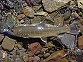 | indicator species for several national forests, including Boise National Forest and Sawtooth National Forest (Sawtooth National Recreation Area). They can... 24 KB (2,753 words) - 23:35, 19 February 2024 |
Confederate monuments and memorials (section National) National Forests of the Intermountain Region. United States Forest Service. 1981. p. 46. "Is there a Robert E. Lee campground in the Boise National Forest... 367 KB (34,005 words) - 18:52, 2 May 2024 |
 | Deadwood Reservoir (category Boise National Forest) States, in Valley County, Idaho. Located in the mountains of the Boise National Forest about 25 miles (40 km) southeast of Cascade, the 3,000-acre (12 km2)... 10 KB (397 words) - 12:00, 21 January 2024 |
 | about a ten square mile area. It is located in the Boise National Forest and the Sawtooth National Forest.. It includes the ghost town of Rocky Bar and a... 2 KB (216 words) - 05:54, 5 August 2023 |
 | Hells Canyon National Recreation Area and the Hells Canyon to the west, Salmon-Challis National Forest to the east, Boise National Forest to the south... 5 KB (465 words) - 15:38, 9 October 2022 |
 | Archived from the original (PDF) on September 24, 2015. Retrieved December 26, 2014. Boise National Forest (Map). 1:126720. U.S. Forest Service. 2012.... 3 KB (131 words) - 15:50, 1 May 2023 |
 | It is bounded on the north by the Payette National Forest and on the south by the Boise National Forest. Located at 4,802 feet (1,464 m), Yellow Pine... 13 KB (628 words) - 00:12, 17 January 2024 |
 | Ada County, Idaho (category Boise metropolitan area) maintained by the Ada County Highway District. Boise National Forest (part) Snake River Birds of Prey National Conservation Area (part) As of the 2010 census... 28 KB (2,098 words) - 00:29, 24 April 2024 |
 | Grandjean Peak (category Boise National Forest) of Stanley, Idaho, in the Sawtooth Wilderness on land managed by Boise National Forest. Precipitation runoff from the mountain's slopes drains to the South... 4 KB (290 words) - 05:18, 19 September 2023 |
 | Retrieved 2013-12-31. "Small streams: Silver Creek". Fishing Boise National Forest. United States Forest Service. 2007. Retrieved 2007-06-03. "Silver Creek".... 3 KB (283 words) - 04:56, 27 October 2022 |
 | tributary of the South Fork Payette River, flowing through Boise National Forest in Valley and Boise counties, Idaho in the United States. It joins the South... 4 KB (191 words) - 16:12, 14 September 2022 |