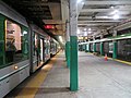
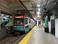
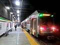
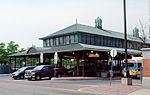
 | Boylston station (also signed as Boylston Street) is a light rail station on the MBTA Green Line in downtown Boston, Massachusetts, located on the southeast... 18 KB (1,851 words) - 04:24, 18 March 2024 |
 | downtown, with stations at Boylston, Park Street, Government Center, Haymarket, and North Station – all with connections to other lines of the MBTA subway system... 87 KB (8,773 words) - 19:00, 6 May 2024 |
 | Chinatown station is a rapid transit station on the Massachusetts Bay Transportation Authority (MBTA) Orange Line, located at the edge of the Chinatown... 19 KB (1,750 words) - 02:50, 6 April 2024 |
 | Copley station is an underground light rail station on the MBTA Green Line, located in the Back Bay section of Boston, Massachusetts. Located in and named... 12 KB (1,227 words) - 05:48, 15 March 2024 |
 | Arlington station is an underground light rail station on the Massachusetts Bay Transportation Authority (MBTA) Green Line located at the southwest corner... 15 KB (1,253 words) - 00:20, 20 April 2024 |
New York Boylston, Wisconsin Boylston Junction, Wisconsin Boylston Street in Boston, Massachusetts Boylston (MBTA station), a subway station in Boston... 605 bytes (93 words) - 14:55, 6 January 2024 |
 | phase. In 1999, the MBTA designated the Washington Street and Transitway projects as the Silver Line, and planned for the Boylston tunnel extension to... 111 KB (11,039 words) - 18:24, 22 April 2024 |
 | Stony Brook station is a rapid transit station in Boston, Massachusetts. It serves the MBTA Orange Line and is located below grade at Boylston Street in... 9 KB (859 words) - 00:32, 10 May 2024 |
 | Newbury Street building. MBTA bus routes 1 and 55 stop near the station. A normally closed secondary entrance from Boylston Street leads to a smaller... 40 KB (3,967 words) - 05:50, 15 March 2024 |
 | Kenmore station is a light rail station on the MBTA Green Line, located under Kenmore Square in the Fenway/Kenmore neighborhood of Boston, Massachusetts... 21 KB (2,012 words) - 05:50, 15 March 2024 |
 | Park Street station is an MBTA subway station in Boston, Massachusetts. It is located at the intersection of Park Street and Tremont Street at the eastern... 42 KB (4,282 words) - 12:50, 7 May 2024 |
 | Boylston, Park Street, Downtown Crossing, South Station, State, Government Center, Haymarket, North Station, Airport, and Ashmont. Interactive MBTA Subway... 23 KB (2,083 words) - 16:58, 20 April 2024 |
 | Transportation Authority (MBTA) as part of the MBTA subway system. The line runs south on the surface from Oak Grove station in Malden, Massachusetts through... 59 KB (5,699 words) - 02:50, 20 April 2024 |
 | building Steinert Hall Trinity Church The MBTA Green Line follows Boylston Street in Back Bay, with stops at Boylston, Arlington, Copley, and Hynes Convention... 8 KB (674 words) - 10:48, 27 March 2024 |
 | Prudential station is an underground light rail station on the MBTA Green Line E branch, located below Huntington Avenue next to the Prudential Tower complex... 6 KB (544 words) - 08:28, 8 October 2023 |
 | Downtown Crossing station (often known as DTX) is an underground Massachusetts Bay Transportation Authority (MBTA) rapid transit station located in the Downtown... 25 KB (2,328 words) - 01:18, 6 April 2024 |
 | This is a list of MBTA subway stations in Boston and surrounding municipalities. All stations are operated by the Massachusetts Bay Transportation Authority... 57 KB (537 words) - 08:06, 25 February 2024 |
 | subway system as well as MBTA buses. Harvard averaged 18,528 entries each weekday in FY2019, making it the third-busiest MBTA station after Downtown Crossing... 65 KB (7,082 words) - 22:21, 19 April 2024 |
 | Northeastern University station (signed as Northeastern) is a surface-level trolley stop on the MBTA Green Line. It is located in a dedicated median along... 7 KB (581 words) - 22:07, 30 November 2023 |
 | Tremont Street subway (redirect from Boylston Street portal) connecting Boylston Street to Park Street and Government Center stations. The tunnel originally served five closely spaced stations: Boylston, Park Street... 14 KB (1,372 words) - 11:31, 2 March 2024 |
 | Government Center station is an MBTA subway station in Boston, Massachusetts. It is located at the intersection of Tremont, Court and Cambridge Streets... 32 KB (3,195 words) - 21:10, 10 May 2024 |
 | Massachusetts, operated by the Massachusetts Bay Transportation Authority (MBTA) as part of MBTA bus service. The route runs southwest from downtown Boston along... 5 KB (574 words) - 00:24, 21 July 2023 |
 | Symphony station is an underground light rail station in Boston, Massachusetts on the E branch of the MBTA Green Line. It is located at the intersection... 10 KB (862 words) - 22:27, 16 August 2023 |
 | Longwood Medical Area station is a light rail stop on the MBTA Green Line E branch, located in the Mission Hill neighborhood of Boston, Massachusetts.... 4 KB (363 words) - 11:52, 5 May 2024 |
 | steep grade and the proximity to Boylston station. In September 1968, the MBTA began construction of the shell of a station - then called South Cove - and... 12 KB (1,152 words) - 22:57, 5 May 2024 |
 | Terminal) is a ground-level Massachusetts Bay Transportation Authority (MBTA) bus station located in Nubian Square (formerly Dudley Square) in the Roxbury neighborhood... 13 KB (1,250 words) - 05:35, 11 April 2024 |
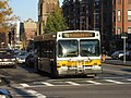
 | quarter of 2023. Most MBTA bus routes are local service operated in Boston and its inner suburbs and connect to MBTA subway stations. Fifteen high-ridership... 48 KB (4,500 words) - 19:43, 5 May 2024 |
 | Green Line E branch (redirect from Hyde Square (MBTA station)) Avenue subway. The line merges into the Boylston Street subway just west of Copley, running to North Station via the Tremont Street subway. It then follows... 84 KB (8,619 words) - 07:32, 5 May 2024 |
 | Eliot station is a light rail station on the MBTA Green Line D branch located just north of Route 9 (Boylston Street) between the Newton Highlands and... 5 KB (355 words) - 00:12, 7 May 2024 |
 | Charles/MGH station is a rapid transit station on the MBTA Red Line, elevated above Charles Circle on the east end of the Longfellow Bridge in the West... 31 KB (2,964 words) - 08:51, 31 December 2023 |