 | the town named Braničevo also existed in the area, at the estuary of the river Mlava into Danube. In the Early Middle Ages, Braničevo became a part of... 11 KB (691 words) - 23:34, 11 November 2023 |
Braničevo may refer to: Braničevo (region) [sr], a region in Serbia Braničevo Fortress, a fortress in Serbia, in Selo Kostolac Braničevo District, a district... 585 bytes (95 words) - 11:17, 20 August 2022 |
Frederick Barbarossa passed through Braničevo on the Third Crusade. Western sources accuse the duke of Braničevo (dux de Brandicz) of treachery. With... 4 KB (316 words) - 15:44, 2 October 2023 |
 | has six monks and one nun, which makes it the largest one in the Braničevo District. Because of the several historical healers who dwelled in the monastery... 13 KB (1,775 words) - 02:05, 18 December 2022 |
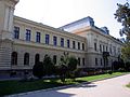 | Požarevac (category Populated places in Braničevo District) pronounced [pǒʒarevats]) is a city and the administrative centre of the Braničevo District in eastern Serbia. It is located between three rivers: Danube, Great... 19 KB (1,405 words) - 11:54, 11 February 2024 |
Četereže (category Populated places in Braničevo District) 44.36861°N 21.24278°E / 44.36861; 21.24278 Country Serbia District Braničevo District Municipality Žabari Population (2002) • Total 641 Time zone... 2 KB (76 words) - 19:01, 24 May 2023 |
Braničevo District League is a section of the District Leagues, Serbia's fifth football league. The league is operated by the Football Association of Serbia... 2 KB (136 words) - 09:24, 9 December 2023 |
Knežica (Petrovac) (category Populated places in Braničevo District) 44.39917°N 21.42861°E / 44.39917; 21.42861 Country Serbia District Braničevo District Municipality Petrovac na Mlavi Time zone UTC+1 (CET) • Summer... 2 KB (46 words) - 15:25, 11 December 2017 |
Lopušnik (category Populated places in Braničevo District) 44.36389°N 21.34750°E / 44.36389; 21.34750 Country Serbia District Braničevo District Municipality Petrovac na Mlavi Time zone UTC+1 (CET) • Summer... 2 KB (46 words) - 03:20, 6 January 2018 |
Šapine (category Populated places in Braničevo District) 44.57250°N 21.36333°E / 44.57250; 21.36333 Country Serbia District Braničevo District Municipality Malo Crniće Population (2002) • Total 1,064 Time... 2 KB (72 words) - 10:01, 23 August 2023 |
Milatovac (Žagubica) (category Populated places in Braničevo District) 44.26083°N 21.76639°E / 44.26083; 21.76639 Country Serbia District Braničevo District Municipality Žagubica Population (2002) • Total 22,828 Time... 2 KB (71 words) - 16:29, 24 June 2017 |
Bliznak (Žagubica) (category Populated places in Braničevo District) 44.17917°N 21.54583°E / 44.17917; 21.54583 Country Serbia District Braničevo District Municipality Žagubica Population (2002) • Total 361 Time zone... 2 KB (71 words) - 03:11, 30 May 2017 |
Zabrđe (Petrovac) (category Populated places in Braničevo District) 44.38250°N 21.36861°E / 44.38250; 21.36861 Country Serbia District Braničevo District Municipality Petrovac na Mlavi Time zone UTC+1 (CET) • Summer... 2 KB (38 words) - 09:44, 21 March 2017 |
Kasidol (category Braničevo District geography stubs) 44.63139°N 21.32278°E / 44.63139; 21.32278 Country Serbia District Braničevo District City Požarevac Population (2002) • Total 744 Time zone UTC+1... 3 KB (81 words) - 01:22, 5 February 2018 |
Rabrovo (Kučevo) (category Populated places in Braničevo District) Rabrovo Village Country Serbia District Braničevo District Municipality Kučevo Population (2002) • Total 1,219 Time zone UTC+1 (CET) • Summer (DST)... 2 KB (71 words) - 13:43, 28 November 2021 |
Vojilovo (category Populated places in Braničevo District) 44.63417°N 21.59444°E / 44.63417; 21.59444 Country Serbia District Braničevo District Municipality Golubac Population (2002) • Total 290 Time zone... 2 KB (71 words) - 06:42, 4 July 2017 |
in the Province of Florence, Italy Vinci (Golubac), a community in Braničevo District, Serbia Alessandro Vinci (born 1987), Italian footballer Alessio Vinci... 2 KB (226 words) - 23:57, 29 August 2023 |
Ranovac (category Populated places in Braničevo District) 44.44000°N 21.47528°E / 44.44000; 21.47528 Country Serbia District Braničevo District Municipality Petrovac na Mlavi Time zone UTC+1 (CET) • Summer... 2 KB (46 words) - 14:25, 10 April 2018 |
Dobrnje (category Populated places in Braničevo District) 21°20′59″E / 44.33806°N 21.34972°E / 44.33806; 21.34972 Country Serbia District Braničevo Municipality Petrovac na Mlavi Time zone UTC+1 (CET) • Summer (DST)... 3 KB (50 words) - 05:03, 1 October 2019 |
 | Ceremošnja (category Populated places in Braničevo District) This Braničevo District, Serbia location article is a stub. You can help Wikipedia by expanding it.... 2 KB (48 words) - 21:13, 14 March 2017 |
Tabanovac (category Populated places in Braničevo District) 44.28556°N 21.38667°E / 44.28556; 21.38667 Country Serbia District Braničevo District Municipality Petrovac na Mlavi Time zone UTC+1 (CET) • Summer... 2 KB (46 words) - 16:47, 15 March 2021 |
Stamnica (category Populated places in Braničevo District) 44.35611°N 21.52139°E / 44.35611; 21.52139 Country Serbia District Braničevo District Municipality Petrovac na Mlavi Time zone UTC+1 (CET) • Summer... 2 KB (46 words) - 09:19, 30 May 2018 |
Voluja (category Populated places in Braničevo District) 44.48861°N 21.77194°E / 44.48861; 21.77194 Country Serbia District Braničevo District Municipality Kučevo Population (2002) • Total 1,123 Time zone... 2 KB (71 words) - 06:57, 4 July 2017 |
Bistrica (Petrovac) (category Populated places in Braničevo District) Bistrica is a village situated in Petrovac na Mlavi municipality, Braničevo District in Serbia. "Institut national d'études démographique (INED)". Archived... 3 KB (52 words) - 16:28, 24 July 2020 |
 | municipalities/cities, there are 24 districts (okruzi, 10 most populated listed below), with the City of Belgrade constituting an additional district. Except for Belgrade... 271 KB (24,695 words) - 08:34, 9 May 2024 |
Miljević (category Populated places in Braničevo District) 44.64278°N 21.51972°E / 44.64278; 21.51972 Country Serbia District Braničevo District Municipality Golubac Population (2002) • Total 527 Time zone... 2 KB (71 words) - 16:16, 24 June 2017 |
Dušmanić (category Populated places in Braničevo District) 21°33′E / 44.583°N 21.550°E / 44.583; 21.550 Country Serbia District Braničevo District Municipality Golubac Population (2002) • Total 176 Time zone... 2 KB (69 words) - 10:52, 7 June 2017 |
Šuvajić (category Populated places in Braničevo District) 44.66667°N 21.51861°E / 44.66667; 21.51861 Country Serbia District Braničevo District Municipality Golubac Population (2002) • Total 339 Time zone... 2 KB (71 words) - 00:47, 2 July 2017 |
held in all 4 municipalities of Bor District. Local elections were held in all 9 municipalities of Braničevo District, including the City of Požarevac.... 286 KB (14,996 words) - 06:57, 9 May 2024 |
Kučajna (category Populated places in Braničevo District) 44.45139°N 21.65361°E / 44.45139; 21.65361 Country Serbia District Braničevo District Municipality Kučevo Population (2002) • Total 468 Time zone... 2 KB (71 words) - 18:56, 22 June 2017 |