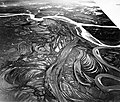
 | The Burdekin River is a river in North and Far North Queensland, Australia. The river rises on the northern slopes of Boulder Mountain at Valley of Lagoons... 27 KB (2,755 words) - 00:41, 27 February 2024 |
 | district is located between Townsville and Bowen in the delta of the Burdekin River. The shire covers an area of 5,044 square kilometres (1,947 sq mi).... 14 KB (710 words) - 09:11, 19 February 2024 |
 | The Burdekin Falls Dam, also known as the Burdekin Dam, is a concrete gravity dam with an uncontrolled spillway across the Burdekin River in the Whitsunday... 11 KB (887 words) - 00:37, 4 January 2024 |
 | The Burdekin Bridge (known as the Burdekin River Bridge or Silver Link) spans the Burdekin River between the towns of Ayr (locality of McDesme) to the... 15 KB (1,203 words) - 10:49, 2 December 2023 |
 | HMAS Burdekin (K376) was a River-class frigate that served the Royal Australian Navy (RAN) from 1944 to 1946. She was named for the Burdekin River in Queensland... 5 KB (315 words) - 00:41, 6 May 2023 |
 | Home Hill, Queensland (category Shire of Burdekin) Burdekin, Queensland, Australia. In the 2016 census, the locality of Home Hill had a population of 2,954 people. At the delta of the Burdekin River,... 46 KB (4,486 words) - 19:08, 23 April 2024 |
 | species is endemic to Australia, originating from the lower region of the Burdekin River area in northern Queensland, and was named after conservationist and... 10 KB (1,035 words) - 10:38, 17 January 2024 |
 | Ayr, Queensland (redirect from Parkside, Queensland (Burdekin Shire)) north of Mackay. Ayr is located near the delta of the Burdekin River. It is within the Burdekin Shire, which produces the most sugar cane per square kilometre... 49 KB (4,305 words) - 11:01, 4 May 2024 |
 | as the coal-mining towns of Collinsville, Moranbah and Clermont. The Burdekin River flows through part of the electorate. The 1949 redistribution abolished... 4 KB (145 words) - 06:02, 8 March 2023 |
 | Cardwell, and pioneered the opening up of the Herbert, Burdekin, Johnstone and Daintree River regions to British colonisation. During this time he was... 29 KB (3,654 words) - 13:29, 28 February 2024 |
park has unique features such as ancient lava flows and the Burdekin River, the largest river in Queensland. This is the land of Gudjal Aboriginal people... 5 KB (448 words) - 16:00, 1 May 2024 |
 | enjoyed approximately 2600 km2 of coastal country from the mouth of the Burdekin River north to Cape Cleveland, inland to Leichhardt Range, in the state of... 8 KB (500 words) - 08:41, 12 April 2024 |
 | Burdekin River Pumping Station is a heritage-listed pumping station at Weir Road, Breddan, Charters Towers Region, Queensland, Australia. It was built... 22 KB (3,198 words) - 23:11, 12 May 2023 |
The Burdekin Gap, named for the Burdekin River, is a biogeographical feature in Queensland, northeastern Australia, which separates populations of freshwater... 1 KB (129 words) - 21:59, 23 April 2024 |
legislature Townsville-Burdekin School District, Burdekin Shire, Queensland, Australia Burdekin River, Queensland, Australia; a river Burdekin Valley, Queensland... 2 KB (237 words) - 08:35, 10 May 2023 |
was born in Dorset but came from an Australian family after whom the Burdekin River was named. He was educated at Cheltenham College and at New College... 3 KB (256 words) - 20:12, 24 May 2023 |
The Running River rainbowfish (Melanotaenia sp., also known as the Burdekin rainbowfish, Hidden Valley rainbowfish or zig zag rainbowfish) is an undescribed... 2 KB (248 words) - 22:28, 11 January 2024 |
(Northern Territory) Dry River (Queensland), a tributary of the Burdekin River Dry River (Victoria), a tributary of the Mitchell River catchment in the Alpine... 890 bytes (148 words) - 20:18, 27 March 2022 |
 | List of drainage basins by area (redirect from List of River Basins) Madeira river basin at Rivers Network. Amur river basin at Rivers Network Lower, Middle and Upper Euphrates river basin at Rivers Network Dnieper river : Watersheds... 75 KB (1,411 words) - 23:24, 25 April 2024 |
 | Burdekin River Rail Bridge is a heritage-listed former railway bridge on the Great Northern railway over the Burdekin River at Dotswood, Charters Towers... 9 KB (1,245 words) - 17:12, 30 April 2024 |
 | Upstart Bay (category Shire of Burdekin) Upstart Bay is a bay in the Burdekin Shire, Queensland, Australia. It is part of the Coral Sea and is the mouth of the Burdekin River. Yuru (also known as Juru... 2 KB (180 words) - 10:16, 17 June 2023 |
 | grunter is endemic to northern Australia from the upper Burdekin River in Queensland to the Daly River in the Northern Territory It has been reported from... 5 KB (618 words) - 23:53, 2 July 2023 |
 | localities of Greenvale and the Valley of Lagoons, and in the Upper Burdekin River area and in Abergowrie. Warrgamay (also known as Waragamai, Wargamay... 14 KB (1,251 words) - 23:24, 18 January 2024 |
 | into the Burdekin River. The Don River which flows into the sea near Bowen has an alluvial plain and a small delta. To the north of the Don River is a narrow... 4 KB (548 words) - 19:47, 28 March 2024 |
 | Anabranch (category Rivers) 15 km out of Charters Towers (Queensland/Australia) is a section of the Burdekin River known as 'the anabranch'. This strip of water is separate from the main... 5 KB (659 words) - 00:53, 23 March 2023 |
Dalrymple is a former township on the western bank of the Burdekin River, Charters Towers Region, Queensland, Australia. Established in 1864 as a police... 4 KB (356 words) - 01:02, 20 February 2021 |
 | as high as 36 °C (97 °F) in the Alligator Rivers region and as low as 20.5 °C (68.9 °F) in the Burdekin river region; these are believed to be the upper... 16 KB (1,878 words) - 08:21, 3 April 2024 |
 | Inkerman Bridge (category Burdekin River) Bridge was a railway bridge over the Burdekin River between McDesme and Home Hill, both in the Shire of Burdekin, Queensland, Australia. It was in operation... 8 KB (663 words) - 00:22, 30 April 2024 |
 | the reserve bounded by School Street, Cemetery Road, Railway Street and Burdekin Falls Dam Road, Ravenswood, Charters Towers Region, Queensland, Australia... 102 KB (14,791 words) - 00:16, 26 January 2024 |
 | women. He was employed as a stockman at Fanning Downs Station on the Burdekin River – about 20 km (12 mi) east of Charters Towers – where he met the governess... 128 KB (18,485 words) - 05:30, 9 May 2024 |