Cadastral surveying is the sub-field of cadastre and surveying that specialises in the establishment and re-establishment of real property boundaries.... 7 KB (971 words) - 08:43, 9 January 2024 |
 | Cadastre (redirect from Cadastral Survey) as a means of more precise tax assessment. Cadastral surveying is the sub-field of cadastre and surveying that specialises in the establishment and re-establishment... 16 KB (1,836 words) - 16:20, 23 April 2024 |
 | Surveying or land surveying is the technique, profession, art, and science of determining the terrestrial two-dimensional or three-dimensional positions... 56 KB (7,086 words) - 11:29, 4 April 2024 |
 | Related to cartography, property boundary surveying using the metes and bounds system and cadastral surveying relies on fractions of a degree to describe... 27 KB (3,331 words) - 03:26, 23 January 2024 |
 | Civil engineering (section Surveying) both of which are generally referred to as Cadastral surveying. Construction surveying Construction surveying is generally performed by specialized technicians... 38 KB (3,977 words) - 06:05, 28 April 2024 |
Mandate government laws regulated and empowered surveying, surveyors, and survey fees. Cadastral Survey Ordinance 1920, published in the Official Gazette... 44 KB (4,192 words) - 19:26, 7 February 2024 |
Civil engineering surveying, a survey of local topographic features for engineering purposes Cadastral surveying, the surveying of specific land parcels to... 718 bytes (118 words) - 05:50, 16 October 2018 |
Institution of Surveyors Victoria (category Surveying organizations) that teach surveying helping to formulate educational standards for cadastral surveyors conveying the opinions and expert advice of the surveying profession... 31 KB (4,131 words) - 18:22, 19 April 2024 |
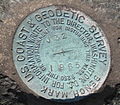 | Benchmark (surveying), a surveying mark used as a reference point in measuring altitudes Boundary marker Milestone Triangulation station, a surveying mark used... 10 KB (1,244 words) - 18:30, 29 November 2023 |
 | and maps of India. Surveys: geodetic datum, geodetic control network, topographical control, geophysical surveys, cadastral surveying, geologic maps, aeronautical... 14 KB (1,166 words) - 18:39, 21 April 2024 |
Chartered Surveyor (section Building surveying) Essentially, land surveying is making accurate maps and plans. Land surveying encompasses cadastral surveying, cartography, engineering surveying, hydrographic... 15 KB (1,444 words) - 20:37, 27 March 2024 |
Land description (category Surveying) Cartography,Official Surveys:Cadastral Surveying, by L.M. Sebert Vancouver, a Visual History, Bruce MacDonald, 1992, page 15 Cadastral Map of British Columbia... 3 KB (387 words) - 01:30, 30 June 2023 |
A cadastral community (or cadastre community, cadastral [or cadastre] municipality, cadastral [or cadastre] commune, cadastral [or cadastre] unit, cadastral... 10 KB (920 words) - 06:35, 28 April 2024 |
 | demand. Under the zabt system, the Mughals also conducted extensive cadastral surveying to assess the area of land under plough cultivation, with the Mughal... 180 KB (16,678 words) - 22:59, 1 May 2024 |
Construction surveying or building surveying (otherwise known as "staking", "stake-out", "lay-out", or "setting-out") is to provide dimensional control... 17 KB (2,019 words) - 07:37, 30 January 2024 |
 | Topographic map (redirect from Topographic surveying and mapping) variety of elevations and landforms. This is in contrast to older cadastral surveys, which primarily show property and governmental boundaries. The first... 20 KB (2,043 words) - 19:20, 2 May 2024 |
quantitative information about items in a population Survey (human research), including opinion polls Surveying, the technique and science of measuring positions... 3 KB (463 words) - 13:33, 1 November 2023 |
 | In surveying, an initial point is a datum (a specific point on the surface of the earth) that marks the beginning point for a cadastral survey. The initial... 4 KB (459 words) - 01:19, 3 December 2023 |
| The Public Land Survey System (PLSS) is the surveying method developed and used in the United States to plat, or divide, real property for sale and settling... 53 KB (6,025 words) - 01:03, 23 April 2024 |
 | Geomatics (redirect from Surveying engineering) navigation satellite system (GNSS) Surveying (including land, cadastral, aerial, mining and engineering surveying) Hydrography Navigation Location-based... 16 KB (1,574 words) - 03:54, 9 April 2024 |
 | These figures are based on 2.515 metres (8 ft 3.0 in) High Water Mark cadastral survey boundaries. It has an exclusive economic zone of 1,067 km2 (412 sq mi)... 22 KB (2,614 words) - 07:48, 7 April 2024 |
 | Russian census); 12,751 (2002 Census). Strelna was first mentioned in Cadastral surveying of Vodskaya pyatina in 1500, as the village of Strelna on Retse Strelne... 10 KB (1,092 words) - 16:59, 18 December 2023 |
than the presently used term. In The Cadastral Map in the Service of the State, mention is made of cadastral survey and subsequent tax collection in northern... 14 KB (1,487 words) - 19:10, 22 December 2023 |
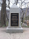 | Illinois, Michigan, Wisconsin, and Minnesota. The survey is claimed to be the first major cadastral survey undertaken by any nation. The point now lies underwater... 6 KB (587 words) - 01:36, 6 April 2024 |
telecommunications networks. Parcel fabric An integrated dataset for storing cadastral surveying data, which describe real property parcels using distance-direction... 31 KB (3,473 words) - 07:29, 22 April 2024 |
 | market demand. Under the zabt system, the Mughals conducted extensive cadastral surveying to assess the cultivated area. The Mughal state encouraged greater... 130 KB (14,226 words) - 12:20, 14 April 2024 |
 | Tsushima was a political and economic abstraction based on periodic cadastral surveys and projected agricultural yields. In other words, the domain was... 15 KB (846 words) - 20:34, 8 February 2024 |
 | Mito was a political and economic abstraction based on periodic cadastral surveys and projected agricultural yields. In other words, the domain was... 27 KB (3,129 words) - 18:19, 11 January 2023 |
Hideyoshi's system saw the han become an abstraction based on periodic cadastral surveys and projected agricultural yields, rather than delineated territory... 11 KB (966 words) - 10:13, 15 April 2024 |
 | domain was a political and economic abstraction based on periodic cadastral surveys and projected agricultural yields. In other words, the domain was... 11 KB (893 words) - 19:27, 6 November 2023 |