21 routes assigned to the "G" zone of the California Route Marker Program, which designates county routes in California. The "G" zone includes county highways...
79 KB (6,434 words) - 15:01, 25 April 2024
County routes in the U.S. state of California are controlled and maintained by the respective counties in which they are located. However, they are generally...
50 KB (444 words) - 00:29, 25 April 2024

98°W / 33.73; -115.98 Riverside County is a county located in the southern portion of the U.S. state of California. As of the 2020 census, the population...
139 KB (6,178 words) - 15:20, 23 April 2024

Southern California, United States. As of the 2020 census, the population was 3,186,989, making it the third-most-populous county in California, the sixth-most-populous...
211 KB (16,574 words) - 22:03, 10 May 2024

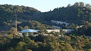
Santa Clara County, officially the County of Santa Clara, is the sixth-most populous county in the U.S. state of California, with a population of 1,936...
108 KB (6,327 words) - 17:35, 10 May 2024

stub as both Route 7 and Route 710. Section 622 of the California Streets and Highways Code defines Route 710 as "from Route 1 to Route 210 in Pasadena"...
41 KB (3,300 words) - 08:21, 1 May 2024

Mono County (/ˈmoʊnoʊ/ MOH-noh) is a county located in the east central portion of the U.S. state of California. As of the 2020 census, the population...
48 KB (2,026 words) - 15:18, 23 April 2024

San Mateo County (/ˌsæn məˈteɪ.oʊ/ SAN mə-TAY-oh), officially the County of San Mateo, is a county in the U.S. state of California. As of the 2020 census...
107 KB (5,505 words) - 17:40, 10 May 2024

List of UTC offsets (redirect from Time Zone Map)
Island Mexico Baja California United Kingdom Pitcairn Islands United States (Pacific Time Zone) California Idaho The northern counties of Benewah, Bonner...
60 KB (4,181 words) - 17:58, 27 March 2024

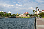
The nearby State Routes 41 and 46 provide access to the Pacific Coast and the Central Valley of California. Founded by E. G. Lewis in 1913, the city grew...
31 KB (3,216 words) - 06:27, 18 May 2024

Mendocino County (/ˌmɛndəˈsiːnoʊ/ ; Mendocino, Spanish for "of Mendoza") is a county located on the North Coast of the U.S. state of California. As of the...
83 KB (4,799 words) - 17:13, 29 April 2024
County (/məˈrɪn/ mə-RIN; Spanish: Condado de Marín) is located in the northwestern part of the San Francisco Bay Area of the U.S. state of California...
91 KB (5,550 words) - 23:31, 9 May 2024

California is a state in the Western United States, lying on the American Pacific Coast. It borders Oregon to the north, Nevada and Arizona to the east...
272 KB (23,678 words) - 18:59, 17 May 2024
Inyo County (/ˈɪnjoʊ/ ) is a county in the eastern central part of the U.S. state of California, located between the Sierra Nevada and the state of Nevada...
65 KB (3,632 words) - 15:14, 23 April 2024

Monterey County (/ˌmɒntəˈreɪ/ MON-tə-RAY), officially the County of Monterey, is a county located on the Pacific coast in the U.S. state of California. As...
88 KB (4,430 words) - 15:18, 23 April 2024

Ventura County (/vɛnˈtʊərə/ ) is a county located in the southern part of the U.S. state of California. As of the 2020 census, the population was 843,843...
139 KB (10,512 words) - 02:54, 24 April 2024

Humboldt County (/ˈhʌmboʊlt/ ) is a county located in the U.S. state of California. As of the 2020 census, the population was 136,463. The county seat is...
132 KB (7,718 words) - 22:54, 14 May 2024
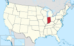
data from zone.tab. The most extensive study of time zone history in Indiana was published in The American Atlas (1978) by Thomas G. Shanks, in which the...
35 KB (3,539 words) - 18:01, 16 February 2024

San Francisco (redirect from San Francisco County, California)
Francisco, officially the City and County of San Francisco, is a commercial, financial, and cultural center in Northern California. With a population of 808,437...
261 KB (24,064 words) - 01:08, 20 May 2024

three-digit route numbers are generally subsidiaries of two-digit primary routes. Of these two-digit routes, the principal north–south routes were assigned...
121 KB (10,945 words) - 06:37, 18 May 2024
2019 Ridgecrest earthquakes (redirect from 2019 earthquake in California)
5 occurred north and northeast of the town of Ridgecrest, California located in Kern County and west of Searles Valley (approximately 200 km [122 mi]...
68 KB (6,302 words) - 18:14, 18 April 2024

Modoc County (/ˈmoʊdɒk/ ) is a county in the far northeast corner of the U.S. state of California. Its population is 8,700 as of the 2020 census, down...
55 KB (3,515 words) - 16:19, 15 May 2024

Sonoma County (/səˈnoʊmə/ ) is located in the U.S. state of California. As of the 2020 United States Census, its population was 488,863. Its seat of government...
138 KB (9,597 words) - 10:08, 15 May 2024

ZIP Code (redirect from Postal zone)
inconsistencies caused by the aforementioned sparse delivery routes, often known as Rural Routes or by some other similar designation. Like area codes, ZIP...
47 KB (5,572 words) - 02:59, 5 May 2024

G2). Routes with letters A, B, and D are in the region of Northern California; letters E, G, and J are in Central California; and N, R, and S are in Southern...
48 KB (2,908 words) - 14:30, 3 May 2024

located in northern Orange County, California, United States. As of the 2020 census, the city had a total population of 143,617. Fullerton was founded in 1887...
67 KB (6,176 words) - 14:57, 14 May 2024
its name with the county, is located in Fresno County. San Joaquin County was one of the original counties of California, created in 1850 at the time of...
79 KB (4,352 words) - 15:26, 23 April 2024
California Valley (Spanish: Valle de California) is an unincorporated community located in the eastern part of San Luis Obispo County, California, in...
17 KB (1,639 words) - 00:34, 1 January 2024

Municipalities of Janos, Ascensión, Juárez, Práxedis G. Guerrero and Guadalupe United States (Mountain Time Zone) Arizona – Navajo Nation only (most of Arizona...
6 KB (460 words) - 23:33, 2 April 2024

the northern portion of the U.S. state of California, spanning the northernmost 48 of the state's 58 counties. Its main population centers include the...
76 KB (5,527 words) - 14:44, 18 May 2024