 | the former and the Norse element may be from "dyn" meaning "noisy". Camastianavaig has a rocky shore with views of the Cuillin and Raasay and is situated... 7 KB (656 words) - 10:07, 26 October 2023 |
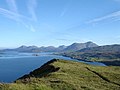 | topographic prominence of at least 150m). It is most simply ascended from Camastianavaig. Despite its proximity to dwellings one could expect to see golden eagles... 1 KB (81 words) - 09:28, 11 April 2022 |
Gaelic Caldey Island Ynys Bŷr Welsh Calgary Calgarraidh Scottish Gaelic Camastianavaig Camas Dìonabhaig Scottish Gaelic Campbeltown Ceann Loch Chille Chiaran... 134 KB (2,086 words) - 04:20, 6 May 2024 |
1966) was a New Zealand plunket nurse. She was born in Balmeanach, near Camastianavaig on the island of Skye, Scotland on 12 November 1878. She was instrumental... 796 bytes (65 words) - 19:25, 16 December 2020 |
 | (Skye) Brevig (Barra) Broadford (Skye) Brogaig (Skye) Bualintur (Skye) Camastianavaig (Skye) Camuscross (Skye) Caolas (Vatersay) Carbost (Loch Harport, Skye)... 45 KB (4,092 words) - 16:04, 19 April 2024 |
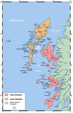
 | Wigtownshire 4,504 900 Portree Highland Inverness-shire Achachork, Camastianavaig, Peinachorran, Portree, Sconser Created from parts of Snizort and Kilmuir... 99 KB (1,000 words) - 17:24, 7 April 2024 |
18978 Upload Photo 12.5 Camastianavaig 57°22′20″N 6°09′00″W / 57.372096°N 6.149963°W / 57.372096; -6.149963 (12.5 Camastianavaig) Category C(S) 18446... 6 KB (277 words) - 06:39, 7 March 2022 |
 | 28400040; -6.46932213 (Talisker Bay) Tianavaig Bay Inverness-shire Camastianavaig 57°22′12″N 6°08′26″W / 57.37009811°N 6.14046115°W / 57.37009811;... 105 KB (4,280 words) - 21:11, 25 April 2024 |
 | being the nearest settlement of any size as the crow flies, although Camastianavaig to the north is closer by road. "Map of Peinchorran, Highland". Streetmap... 2 KB (120 words) - 15:08, 1 January 2023 |
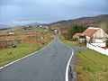
 | Highland. The village lies on the B883 road, with the largest village of Camastianavaig 3 miles (5 kilometres) north, and the settlement of Peinachorran directly... 2 KB (106 words) - 20:10, 22 August 2021 |
 | 0–9 A B C D E F G H I J K L M N O P Q R S T U V W X Y Z Camas Luinie, Camastianavaig, Camault Muir, Camore, Camuscross Camusnagaul, Camusteel, Camusterrach... 19 KB (1,757 words) - 15:32, 23 January 2024 |
 | Highland 56°37′N 5°30′W / 56.61°N 05.50°W / 56.61; -05.50 NM8552 Camastianavaig Highland 57°22′N 6°10′W / 57.37°N 06.16°W / 57.37; -06.16 NG5039... 82 KB (26 words) - 15:47, 8 July 2022 |
 | Oskaig on the Isle of Raasay, and the nearest settlement of any size is Camastianavaig. The hamlet of Peinachorran and Balmeanach is directly to the south... 1 KB (84 words) - 00:05, 23 August 2021 |
 | died and his many projects on Harris and Lewis were abruptly ended. Camastianavaig - site of the "Battle of the Braes" Glendale, Skye The making of the... 7 KB (886 words) - 18:22, 22 August 2021 |