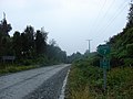
 | The Carretera Austral (CH-7, in English: Southern Way) is the name given to Chile's Route 7. The highway runs south for about 1,240 kilometers (770 mi)... 8 KB (837 words) - 03:57, 15 February 2024 |
2016 song by American singer Prince Royce Carretera Central (disambiguation) Carretera Austral, Chile Carretera de Cádiz, one of the 11 districts of the... 378 bytes (82 words) - 13:51, 16 October 2017 |
 | northern portion of Carretera Austral. It had 3,629 inhabitants as of 2017. Hornopirén is an important tourist stop on Chile’s Carretera Austral (Highway 7) and... 4 KB (111 words) - 04:54, 9 June 2023 |
 | Pan-American Highway (redirect from Carretera Panamericana) again, to Quellón on Chiloé Island, and to its continuation as the Carretera Austral. The other part goes east along Chile Route 60, which goes through... 70 KB (8,739 words) - 10:24, 25 April 2024 |
wildlife stand out. In a broad sense, the route also includes the Carretera Austral, which begins south of the Los Lagos Region and crosses through the... 2 KB (265 words) - 18:38, 12 December 2023 |
 | didn't have road access to the rest of Chile until 1988, when the Carretera Austral was opened. The town was later named Cochrane in honour of Thomas... 12 KB (620 words) - 17:36, 5 October 2023 |
They adjust their expectations, traversing the Aysén region and the Carretera Austral to the port of Chaitén. Here the team elects to cross both the Gulf... 48 KB (4,112 words) - 06:08, 27 February 2024 |
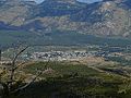
 | showed little interest in exploiting the remote Aisén region. The Carretera Austral southern highway opened in the 1980s. The commune of Coyhaique spans... 15 KB (963 words) - 09:56, 11 April 2024 |
 | Province. Villa O'Higgins is connected to the rest of Chile by the Carretera Austral (Southern Highway) – the final 120 km of which were completed southwards... 7 KB (234 words) - 11:43, 16 August 2023 |
 | example, the opposition by Douglas Tompkins to the planned route for Carretera Austral in Pumalín Park. A scandal is also brewing about two properties owned... 94 KB (11,168 words) - 14:39, 26 April 2024 |
 | Corcovado. The town is strategically close to the northern end of the Carretera Austral, where the highway goes inland. The Desertores Islands are part of... 9 KB (677 words) - 07:25, 24 November 2023 |
 | southwards a well-defined western longitudinal valley, occupied by the Carretera Austral, divides the Andes into two chains, the eastern being the main chain... 18 KB (2,538 words) - 15:37, 30 June 2023 |
 | at the turn of the century. Until the construction of Route 7 (the Carretera Austral, or Southern Highway) in the 1980s, the only overland routes from... 36 KB (3,570 words) - 15:59, 7 April 2024 |
 | km drive from Balmaceda on the Carretera Austral is necessary to reach the park. As of March 2018, the Carretera Austral is only paved between Balmaceda... 19 KB (2,148 words) - 13:28, 25 April 2024 |
 | Chile. Caleta La Arena is located near route CH-7, also known as Carretera Austral, that starts in the city of Puerto Montt, 45 km (28 miles) away. This... 3 KB (311 words) - 22:26, 3 December 2022 |
 | southern Chile in the Aysén Region. It is located on Route 7, the Carretera Austral, where the Rio Pascal enters the head of the Puyuhuapi fjord, a small... 3 KB (267 words) - 17:36, 17 January 2024 |
 | Sound in southern Chile. It lies along the northernmost portion of Carretera Austral. It had 671 inhabitants as of 2017. In colonial times Contao was a... 3 KB (69 words) - 06:36, 14 April 2021 |
 | to the southernmost portion of Carretera Austral and constitutes thus the only discontinuous section of Carretera Austral south of Chaitén. The fjord receives... 1 KB (149 words) - 03:59, 7 January 2024 |
airstrip in the Aysén Region of Chile. A service road connects it to the Carretera Austral. The nearest town is Cochrane, 60 kilometres (37 mi) to the northeast... 2 KB (128 words) - 03:50, 18 March 2023 |
 | Yanteles. This preserved area has one public access trail along the Carretera Austral. Corcovado National Park represents an innovative joint public/ private... 4 KB (411 words) - 07:37, 25 January 2024 |
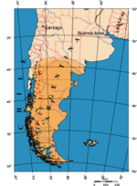
Tourism in Chile (section Zona Austral) traditions. Also is remarkable its temperate rainforests. The scenic Carretera Austral crosses or is nearby to many of the most popular destinations in this... 58 KB (5,624 words) - 09:54, 22 April 2024 |
 | by the municipal government of Puerto Aysén. The town lies by the Carretera Austral in an Andean valley. "Ciudades, pueblos, aldeas y caceríos 2019" (PDF)... 2 KB (62 words) - 14:13, 21 August 2023 |
 | Chiloe on the other side of the Gulf of Corcovado. Traffic on the Carretera Austral along the western shore of Yelcho Lake was interrupted in December... 3 KB (235 words) - 21:14, 7 February 2024 |
 | of the city of Puerto Montt and close to northernmost section of Carretera Austral. The wetland has been the site of various studies of waders and marine... 1 KB (151 words) - 12:50, 1 February 2024 |
(es), a small town in the Aysén Region of Chile. La Junta is on the Carretera Austral highway, 50 kilometres (31 mi) inland from the Gulf of Corcovado.... 2 KB (161 words) - 17:17, 28 December 2023 |
a lakeside hamlet (Spanish: caserío) at the outflow of Yelcho Lake in Chaitén commune, southern Chile. Carretera Austral passes by the hamlet. v t e... 3 KB (28 words) - 14:33, 29 March 2017 |
 | after Cerro Castillo, its highest mountain and main attraction. The Carretera Austral passes through the park. Named a national reserve in 1970, Cerro Castillo... 4 KB (294 words) - 14:52, 19 February 2024 |
magnificent landscape of narrow channels and solitary islands. The Carretera Austral requires the use of three ferries: a 30-minute crossing about 45 kilometers... 37 KB (3,961 words) - 22:36, 14 April 2024 |
that separates Chiloé from the continent and another route named Carretera Austral (Spanish for Southern Highway) that was opened in the 1980s. The southern... 3 KB (358 words) - 19:37, 2 December 2023 |
 | municipality, headed by an alcalde: Cochrane, O'Higgins and Tortel. Carretera Austral "Territorial division of Chile" (PDF) (in Spanish). National Statistics... 6 KB (233 words) - 04:31, 26 June 2021 |