 | The Cayman Trough (also known as the Cayman Trench, Bartlett Deep and Bartlett Trough) is a complex transform fault zone pull-apart basin which contains... 9 KB (967 words) - 03:05, 26 April 2024 |
| oceanic troughs on the ocean floors. Benue Trough Cayman Trough Hesperides Trough Kings Trough Mariana Trough Nankai Trough Northumberland Trough Okinawa... 2 KB (190 words) - 15:36, 25 June 2023 |
| The Cayman Ridge is an undersea mountain range on the northern margin of the Cayman Trough in the Caribbean Sea. It extends from the Sierra Maestra in... 3 KB (168 words) - 03:05, 26 April 2024 |
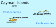 | 8 mi). The islands are located on the Cayman Rise which forms the northern margin of the Cayman Trough. The trough is the deepest point in the Caribbean... 15 KB (814 words) - 06:54, 26 January 2024 |
 | of an undersea mountain range called the Cayman Ridge (or Cayman Rise). This ridge flanks the Cayman Trough, 6,000 m (20,000 ft) deep which lies 6 km... 117 KB (10,659 words) - 11:26, 4 May 2024 |
 | approximately 1,100 km long strip, consisting mainly of oceanic crust of the Cayman Trough but including island arc material at its eastern end on the western... 7 KB (801 words) - 00:48, 8 April 2024 |
| Hispaniola and aong the southern margin of the Cayman Trough. Both fault zones terminate at the Mid-Cayman Rise to the west. Some researchers believe that... 4 KB (419 words) - 21:41, 21 April 2024 |
encounter with an unidentified submerged object and sinks near the Cayman Trough. With Soviet ships moving in to try to salvage the sub and a hurricane... 63 KB (7,604 words) - 07:51, 5 May 2024 |
 | located just south of Grand Cayman in the Caribbean, on the north side of the Mid-Cayman Spreading Centre in the Cayman Trough. Approximately 24 kilometres... 24 KB (2,592 words) - 08:04, 28 April 2024 |
 | 000 km2 (1,063,000 sq mi). The sea's deepest point is the Cayman Trough, between the Cayman Islands and Jamaica, at 7,686 m (25,217 ft) below sea level... 43 KB (4,513 words) - 21:54, 25 April 2024 |
| of 2,216 metres (7,270 ft). Its basins include the Mexico Basin, the Cayman Trough, the Yucatan Basin, the Columbian Basin, the Venezuelan basin and the... 7 KB (486 words) - 01:08, 30 November 2023 |
 | 2020 Caribbean earthquake (section Cayman Islands) the Cayman Trough, north of Jamaica and west of the southern tip of Cuba, with the epicenter being 80 miles (130 km) ESE of Cayman Brac, Cayman Islands... 15 KB (1,223 words) - 01:55, 20 February 2024 |
 | boundary, which extends west between Cuba and Hispaniola through the Cayman Trough to the coast of Central America. The trench is 800 kilometres (497 mi)... 21 KB (2,044 words) - 06:43, 17 February 2024 |
 | Chicxulub impact cf 49 49 Ma Eocene Cayman Trough rifting starts cf 26 20 Ma Oligocene–Miocene Cayman Trough rifting slows down cf 23 22 Ma Miocene... 48 KB (3,738 words) - 02:41, 1 May 2024 |
American Plate. It runs along the southern boundary of the Cayman Trough from the Mid-Cayman Rise spreading center in the east, to Guatemala in the west... 1 KB (151 words) - 13:28, 23 July 2023 |
| The Mid-Cayman Rise or Mid-Cayman Spreading Center is a relatively short (110 km long) divergent plate boundary in the middle of the Cayman Trough. It forms... 6 KB (725 words) - 02:12, 2 January 2024 |
 | Central America. The Motagua Fault is an onshore continuation of the Cayman Trough which forms part of the tectonic boundary between the North American... 107 KB (7,833 words) - 08:06, 29 April 2024 |
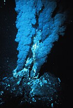 | the critical point of the fluid at that salinity. A vent site in the Cayman Trough named Beebe, which is the world's deepest known hydrothermal site at... 115 KB (13,399 words) - 19:15, 1 May 2024 |
 | of the Oracabessa Bay Fish Sanctuary is located on the edge of the Cayman Trough with walls that begin at 60 ft. and drop down to over 150 ft. These... 15 KB (1,628 words) - 21:22, 28 April 2024 |
 | through the Cayman trough along the Swan Islands Transform Fault before joining the southern boundary of the Gonâve Microplate. East of the Mid-Cayman Rise this... 14 KB (1,419 words) - 02:47, 29 January 2024 |
 | Rico trench along the northern coast of Puerto Rico and on through the Cayman Trough to the coast of Central America. Approximately 50 miles ESE of Fajardo... 5 KB (567 words) - 11:11, 6 March 2023 |
 | diverse reef structure, vibrant marine life and close proximity to the Cayman Trough. Oracabessa has a long history as a Jamaican fishing village, with Oracabessa... 6 KB (635 words) - 05:19, 8 April 2024 |
 | NOAAS Okeanos Explorer (section Océano Profundo 2015: Exploring Puerto Rico's Seamounts, Trenches, and Troughs) construction of the rift valley walls along much of the Mid-Cayman Rise, and the inner wall of the Cayman Trough fracture zone immediately to the north – investigating... 25 KB (2,634 words) - 20:15, 17 October 2023 |
of supercriticality at the vent site. A further site, Beebe, in the Cayman Trough, is thought to display sustained supercriticality at the vent orifice... 41 KB (4,721 words) - 03:27, 20 March 2024 |
| fault, forming part of the southern boundary to the Cayman Trough. It extends from the Mid-Cayman Rise spreading center in the west to Jamaica in the... 1 KB (153 words) - 21:01, 4 April 2024 |
 | Present) Collision of Cuba with Florida Platform and Opening of the Cayman Trough. PALEOMAP Project http://www.scotese.com/caribanim.htm Sigurdsson H... 13 KB (1,551 words) - 21:07, 4 February 2024 |
 | Caledonia trough, which is an extensional sedimentary basin related to the Tonga-Kermadec subduction zone. Additionally, the Cayman Trough, which is a... 48 KB (5,149 words) - 13:14, 3 May 2024 |
establishes a 175 nautical mile-long, complex border in the waters above the Cayman Trough. The boundary consists of 105 straight-line maritime segments defined... 3 KB (202 words) - 01:42, 23 April 2024 |
at the Cayman Trough may explain north-plunging late folds, due to eastward movement of the Caribbean plate. The formation of the Cayman Trough produced... 5 KB (664 words) - 16:16, 9 January 2024 |
 | Graben Western Quebec Seismic Zone United States Caribbean and Mexico Cayman Trough Chixoy-Polochic Fault Enriquillo–Plantain Garden fault zone (Cuba) Gulf... 32 KB (3,764 words) - 13:50, 6 April 2024 |